Mynydd Machen facts for kids
Quick facts for kids Mynydd Machen |
|
|---|---|

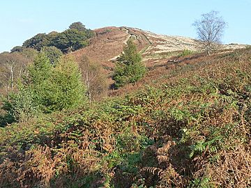
Looking up towards Mynydd Machen
|
|
| Highest point | |
| Elevation | 362 m (1,188 ft) |
| Prominence | 185 m (607 ft) |
| Listing | Marilyn |
| Naming | |
| Language of name | Welsh |
| Geography | |
| Location | Caerphilly, Wales |
| OS grid | ST 224900 |
| Topo map | OS Landranger 171 / Explorer 152 |
Mynydd Machen is a hill in south Wales. It stands about 362 meters (1,188 feet) high. This hill is located between the town of Risca and the village of Machen. Both are in the Caerphilly County Borough. At the very top of Mynydd Machen, you will find a special marker called a trig point. There is also a tall mast there.
Contents
What Mynydd Machen is Made Of
Mynydd Machen is at the edge of the South Wales Coalfield. This area has many different types of rocks. These rocks formed during the Carboniferous Period. They are tilted steeply into the coalfield basin.
Rock Layers on the Hill
The rocks on Mynydd Machen are found in bands. They run from northeast to southwest. Here are some of the main rock layers, from oldest to newest:
- Warwickshire Group
- Pennant Sandstone Formation
- Brithdir Member
- Rhondda member
- Deri Member
- Pennant Sandstone Formation
- South Wales Coal Measures Group
- South Wales Middle Coal Measures Formation
- South Wales Lower Coal Measures Formation
- Marros Group
- Bishopston Mudstone Formation
- Twrch Sandstone Formation
- Pembroke Limestone Group
The very top of the hill is made of a type of sandstone. This sandstone is part of the 'Brithdir Member'. It belongs to the Pennant Sandstone Formation. There is also a large quarry on the south side of the hill. This quarry digs out limestone that contains dolomite. This limestone is from the Pembroke Limestone Group.
Exploring Mynydd Machen
Many public footpaths cross Mynydd Machen. These are paths that everyone can use. Some of these paths are part of popular walking routes.
Popular Walking Routes
You can enjoy several well-known walks on the hill:
- The Rhymney Valley Ridgeway Walk
- The Sirhowy Valley Walk
- The Raven Walk
Open Access Areas
The higher parts of the hill are open to everyone. Most of the woodlands on its slopes are also open. This means you can walk freely in these areas. This is allowed under a law called the Countryside and Rights of Way Act 2000.
 | Dorothy Vaughan |
 | Charles Henry Turner |
 | Hildrus Poindexter |
 | Henry Cecil McBay |

