
Mädelegabel facts for kids
Quick facts for kids Mädelegabel |
|
|---|---|

The Mädelegabel from the south. Below: the Schwarzmilzferner (2009)
|
|
| Highest point | |
| Elevation | 2645m |
| Prominence | 81 m ↓ Windgap with the Hochfrottspitze → Hochfrottspitze |
| Isolation | 0.4 km → Hochfrottspitze |
| Geography | |
|
Lua error in Module:Location_map at line 420: attempt to index field 'wikibase' (a nil value).
|
|
| Parent range | Central Ridge, Allgäu Alps |
| Climbing | |
| First ascent | 1818 |
| Easiest route | from the Heilbronn Way |
The Mädelegabel is a tall mountain located right on the border between Austria and Germany. You can find it near the town of Oberstdorf in the Allgäu Alps. It's known as one of the most famous and popular mountains for climbing in the German Alps.
Contents
About Mädelegabel Mountain
The Mädelegabel stands 2,645 metres (8,678 ft) (about 8,678 feet) high. It is mostly made of a type of rock called Dolomite. This makes it the fourth tallest mountain in the Allgäu Alps. One side of the mountain has a very steep rock face that is 400 meters (about 1,300 feet) tall.
The Famous Mountain Trio
The Mädelegabel is part of a well-known group of three peaks. These are the Mädelegabel itself, the Trettachspitze, and the Hochfrottspitze. Together, they form a famous "trio" of mountains along the main ridge of the Allgäu Alps.
Long ago, the name Mädelegabel was used for all three of these mountains. Later, each peak was given its own special name.
Glacier and First Climb
On the southeastern side of the Mädelegabel, there is a small glacier called the Schwarzmilzferner. A glacier is a large, slow-moving river of ice.
The Mädelegabel was first climbed in 1818. This first ascent was made by a team of people who were surveying the land.
-
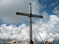
The summit cross at the top of Mädelegabel.
-
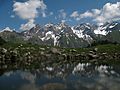
The Mädelegabel group seen from the Guggersee lake.
-
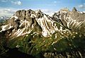
A view showing the Mädelegabel, which is the second peak from the right.


Images for kids
-
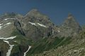
The Mädelegabel (left) and Trettachspitze (right) seen from the east.

See also
 In Spanish: Mädelegabel para niños
