
Nürensdorf facts for kids
Quick facts for kids
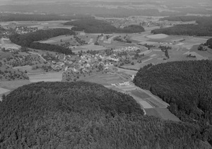
Nürensdorf
|
||
|---|---|---|
 |
||
|
||

Nürensdorf
Location in Switzerland

Nürensdorf
Location in Canton of Zurich
|
||
| Country | Switzerland | |
| Canton | Zurich | |
| District | Bülach | |
| Area | ||
| • Total | 10.04 km2 (3.88 sq mi) | |
| Elevation | 502 m (1,647 ft) | |
| Population
(Dec 2020 )
|
||
| • Total | 5,628 | |
| • Density | 560.6/km2 (1,451.8/sq mi) | |
| Postal code |
8309
|
|
| Surrounded by | Bassersdorf, Brütten, Kloten, Lindau, Oberembrach | |

Nürensdorf is a municipality (which is like a small town or district) located in the Bülach district. It's part of the canton of Zürich in Switzerland. It's a place where many people live and work, surrounded by beautiful nature.
Contents
A Look Back: Nürensdorf's History
Nürensdorf was first mentioned a very long time ago, around the year 1150. Back then, it was called Noelistorf. Later, in 1277, its name changed slightly to Nueristorf. This shows us that the town has been around for many centuries!
Exploring Nürensdorf's Geography
Nürensdorf covers an area of about 10.1 square kilometers (which is about 3.9 square miles). A big part of this area, almost half (48.6%), is used for farming. Another large portion (32.1%) is covered by forests, which are great for exploring nature. The remaining land (19.2%) is where buildings and roads are located.
The municipality is situated on the southwest edge of a high flat area called the Brütten plateau. The main village of Nürensdorf used to be a Straßendorf (a village built along a single road) until about the 1700s. After that, it grew into a Haufendorf, which means it became an irregular, unplanned village with buildings packed closely around a central area.

Nürensdorf also includes several other smaller areas. These are the town sections of Birchwil, Breite, and Oberwil. There are also tiny villages called hamlets, such as Hakab, Breitenloo, and Chlihus. Until 1931, Baltenswil was part of Nürensdorf, but now it belongs to the nearby town of Bassersdorf. Since 1869, the village of Breitehof has also been part of the Nürensdorf municipality.
Who Lives in Nürensdorf?
Nürensdorf is home to about 5,698 people (as of 2022). Over the last ten years, the number of people living here has grown quite a bit, by about 12.9%. This shows that more and more people are choosing to make Nürensdorf their home.
Most people in Nürensdorf speak German (90.6%). Italian is the second most common language (2.2%), followed by French (1.2%). This mix of languages shows that people from different backgrounds live and work together in the community.
When it comes to politics, the most popular political party in the 2007 election was the SVP, which received 45.6% of the votes. Other popular parties included the FDP (15.3%), the SPS (11.8%), and the CSP (9.5%).
Looking at the age groups in Nürensdorf (as of 2000):
- Children and teenagers (ages 0–19) make up 22.5% of the population.
- Adults (ages 20–64) make up the largest group, at 66.2%.
- Seniors (over 64 years old) make up 11.3%.
Many adults in Nürensdorf are well-educated. About 83.9% of people between 25 and 64 years old have finished either a non-mandatory upper secondary education or have gone on to higher education, like university.
Nürensdorf has a low unemployment rate, which means most people who want to work can find jobs. As of 2005, there were 68 people working in the primary economic sector (like farming). The secondary sector (which includes manufacturing and construction) employed 327 people. The largest number of people, 452, worked in the tertiary sector, which includes services like shops, schools, and offices.
See also
 In Spanish: Nürensdorf para niños
