Napeague, New York facts for kids
Quick facts for kids
Napeague, New York
|
|
|---|---|

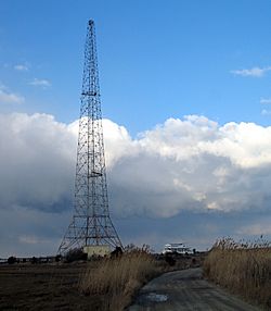
Mackay Tower and Art Barge
|
|
 |
|
| Country | United States |
| State | New York |
| County | Suffolk |
| Town | East Hampton |
| Area | |
| • Total | 8.54 sq mi (22.13 km2) |
| • Land | 3.68 sq mi (9.53 km2) |
| • Water | 4.87 sq mi (12.60 km2) |
| Elevation | 7 ft (2 m) |
| Population
(2020)
|
|
| • Total | 368 |
| • Density | 100.00/sq mi (38.61/km2) |
| Time zone | UTC-5 (Eastern (EST)) |
| • Summer (DST) | UTC-4 (EDT) |
| FIPS code | 36-49424 |
| GNIS feature ID | 0958252 |

Napeague (pronounced NAP-eeg) is a small community in Suffolk County, New York, United States. It's known as a hamlet, which is a small village. In 2020, about 368 people lived there.
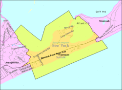
Napeague is located on a very thin strip of land. The Atlantic Ocean is to its south, and Gardiners Bay is to its north. This area was once flooded during a big storm in 1938. Napeague is found between two state parks: Napeague State Park on its west side and Hither Hills State Park on its east side.
The name Napeague comes from the Montaukett Native American language. It means "land overflowed by the sea."
Contents
Famous Places in Napeague
Napeague has three main landmarks that are important to its history. These are the Mackay Radio Tower, the Art Barge, and the Smith Meal Fish Factory.
Mackay Radio Tower
The Mackay Radio Tower is a tall structure that was once part of a pair of towers. These towers were used for sending radio messages around the world starting in 1927. During World War II, the tower helped ships at sea by responding to many SOS calls every day. People worked at the tower 24 hours a day, but the messages were sent from a place called Southampton. The original towers were knocked down during the powerful Great 1938 Hurricane.
On January 28, 1961, an American Airlines Boeing 707 plane, Flight 1502, crashed near Napeague. The plane had an engine on fire and went down about 300 yards off the coast. All six people on board died. The plane was on a training flight from Idlewild Airport. Many stories say the plane hit one of the towers, but The New York Times newspaper reported that it just missed them.
The Mackay towers stopped being used in 1984. The land they stood on is now part of Napeague State Park. One of the towers was taken down. The tower that remains is still used for communication by the New York State Police. Its bright flashing lights can be seen from many places along the coast of East Hampton.
The Art Barge
The Art Barge is a special place for art education. It is home to the Victor D'Amico Institute of Art. Victor D'Amico was the Director of Education for the Museum of Modern Art (MoMA) from 1937 to 1969. In 1955, his department started offering art classes.
D'Amico wanted a permanent place for his art school. In 1955, he worked with local fishermen to bring a retired World War II barge to its current spot. This barge was placed just northeast of the Mackay Towers. It became a summer art school for MoMA. For a while, it was called the Kearsarge Art Center. Kearsarge is a Native American word meaning "place of heaven." A second floor was added to the barge in 1961.
The art center was renamed the Napeague Institute of Art in 1973. Later, in 1981, it was named the Victor D'Amico Institute of Art, after its founder. However, most people still call it "The Art Barge." The Art Barge is open from June through September. There is also the Mabel and Victor D'Amico Studio and Archive. This was the home of Victor and his wife, Mabel Birckhead D'Amico, who was also an artist and teacher. It is located across Napeague Harbor on the Lazy Point peninsula. You can learn more at The Art Barge website.
Smith Meal Fish Factory
The Smith Meal Fish Factory was a plant in a place called Promised Land. This factory processed menhaden fish to make fish meal. Otis Smith owned the factory. It processed between 20 and 30 million fish each year from June to October. The factory even had its own train stop on the Long Island Rail Road just for its workers.
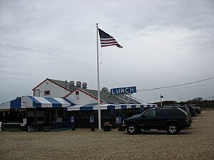
After the number of menhaden fish decreased, Smith closed the plant in 1969. He also closed other plants and moved all operations to Port Monmouth, New Jersey. Next to the old Smith Meal plant, there is a private fish hatchery called Multi Aquaculture Systems. It was started in 1976 by Dr. Robert J. Valenti. There is also a small restaurant nearby.
The closed Smith Meal Fish Factory was sold to The Nature Conservancy. They then gave it to the State Parks Commission. The land is now part of Napeague State Park. There was a long court case about whether the park should be used as a dock for the Cross Sound Ferry. This ferry would carry cars to New London, Connecticut. The park has not been developed since 1986. It is home to a group of piping plover birds that nest there. The future use of the park will depend on protecting these birds.
Water Sports
Napeague Harbor is a very popular spot for kiteboarding and windsurfing on Long Island. The water is calm and the wind is steady. This makes Napeague a great place for both beginners and experienced riders to enjoy these water sports.
Geography of Napeague
The United States Census Bureau says that Napeague covers a total area of about 9.7 square kilometers (3.7 square miles). Most of this is land, about 9.5 square kilometers (3.6 square miles). The rest, about 0.2 square kilometers (0.1 square miles), is water.
After the last ice age, Napeague was actually under the sea. At that time, Montauk was an island. Over thousands of years, ocean currents brought sand to this area. This sand filled in the space, creating the land we now know as Napeague.
The main community in Napeague is a small area called Lazy Point. It is also known as "Promised Land." Local stories say it got this nickname because of the old menhaden fish factory there. People said the factory "stunk to high heaven."
Population of Napeague
| Historical population | |||
|---|---|---|---|
| Census | Pop. | %± | |
| 2020 | 368 | — | |
| U.S. Decennial Census | |||
In 2010, there were 200 people living in Napeague. There were 107 households, and 60 of these were families. The population density was about 53 people per square mile. Most of the people living in Napeague were White (95.5%). A small number were Asian (1.5%), African American (1.0%), or Native American (0.5%). About 3.0% of the population was Hispanic or Latino.
The average household had about 1.87 people, and the average family had about 2.45 people. The median age of people in Napeague was 55.4 years old. This means half the people were younger than 55.4, and half were older.
The median income for a household in Napeague was $93,750. For families, the median income was $120,313. The average income per person was $63,869.
See also
 In Spanish: Napeague para niños
 | Valerie Thomas |
 | Frederick McKinley Jones |
 | George Edward Alcorn Jr. |
 | Thomas Mensah |


