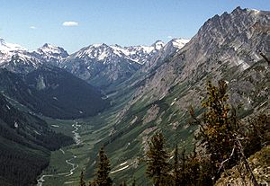
Napeequa River facts for kids
The Napeequa River is a beautiful river in Washington State, located on the east side of the Cascade Range. It's about 19-mile (31 km) long. The river starts in northwest Chelan County and flows southwest into the White River, which then flows into Lake Wenatchee.
The Napeequa River and its valley are famous for being very pretty and quite isolated. The valley is wide with open meadows, surrounded by tall, rugged mountains. The Chiwawa Mountains are on the east side, separating the Napeequa from the Chiwawa River. To the west, the White Mountains separate the Napeequa from the White River. Both are smaller mountain ranges within the larger Cascade Range.
This river is part of the huge Columbia River basin. It flows into the Chiwawa River, which then joins the Wenatchee River, and that river eventually flows into the mighty Columbia River. Many of the names in the Napeequa River area, including the river's name itself, were given by a person named Albert H. Sylvester.
The River's Journey
The Napeequa River begins its journey at Butterfly Glacier in the Glacier Peak Wilderness. It flows west for a short distance before entering its main valley, which stretches southeast. Near the start of the valley, another stream joins the Napeequa. This stream comes from near High Pass.
As the Napeequa flows southeast through its valley, it is joined by Louis Creek from the north. Then, an unnamed stream flows in from the east, coming from Pliz Glacier and Richardson Glacier. Many small streams also tumble down the steep slopes of the Napeequa valley.
The valley becomes much wider and flatter, and the river meanders slowly through it. Hiking trails lead into the valley over high mountain passes like Boulder Pass and Little Giant Pass. These passes are over 6,400 ft (2,000 m) high, while the valley floor is about 4,000 ft (1,200 m) high in this area. Many backpackers also find their way to High Pass or Triad Lake, which are just north of where the Napeequa starts. There are no easy trails directly into the valley; you always have to cross a high pass.
Further downstream, the valley narrows for a bit, then widens again. More tributaries flow down the steep sides of this glacial valley. In its last mile, the Napeequa turns west to join the White River. It's also joined by Lake Creek from the south, which drains Twin Lakes.
The Napeequa Valley actually continues southeast from Twin Lakes, but that part is now home to Big Meadow Creek. Big Meadow Creek flows southeast to the Chiwawa River. It's believed that the Napeequa River once flowed through this entire valley, but its path was "captured" by the Chiwawa River. The Napeequa Valley has even been compared to the famous Shangri-La because of its hidden beauty. This valley is part of the Glacier Peak Wilderness.
How the Valley Was Formed
Fred Beckey, a famous climber, once called the Napeequa River valley the "most interesting valley" in the region. It's a classic example of a U-shaped valley, which means it has a flat bottom and steep sides. This shape was carved out by a huge glacier during the Pleistocene era, also known as the Ice Age.
The lower part of the valley is so wide and flat that the Napeequa River flows very slowly and winds back and forth. Near Twin Lakes, the Napeequa suddenly turns west. It leaves its wide valley by cutting through a steep gorge. This gorge is carved into the hard rock of the 6,500 feet (2,000 m) high ridge between the Napeequa and White River valleys.
Big Meadow Creek now flows through the southern part of this same glacier-carved valley, heading southeast to the Chiwawa River. Scientists believe that the Napeequa River used to flow through this entire valley, including the southern end where Big Meadow Creek is now. It's also likely that a large lake formed in the valley as the ancient glacier melted away.
The River's Name
The Napeequa River was once known by a different name: the North Fork of the White River. However, a Forest Service supervisor named A.H. Sylvester decided to change its name to Napeequa.
The name "Napeequa" comes from a Salishan word that means white water. This is a very fitting name because the river's water often looks almost white during the spring and summer. This happens because of the large amount of fine silt, like tiny bits of rock, that the melting glaciers carry into the river. According to William Bright, the name might also come from a Sinkiuse-Columbia word meaning white water place.
 | Calvin Brent |
 | Walter T. Bailey |
 | Martha Cassell Thompson |
 | Alberta Jeannette Cassell |


