
National Register of Historic Places listings in Adams County, Indiana facts for kids

This article is about special places in Adams County, Indiana, that are listed on the National Register of Historic Places. This register is like a special list kept by the United States government. It helps protect buildings, sites, and objects that are important to history, architecture, archaeology, engineering, or culture. When a place is on this list, it means it's recognized for its value and efforts are made to preserve it for future generations.
In Adams County, there are 9 different places that have been added to this important list. These places are found in different towns and areas across the county. Some are in cities like Decatur or Geneva, while others are in smaller areas called townships. Each one tells a unique story about Adams County's past.
What is the National Register of Historic Places?
The National Register of Historic Places is the official list of the nation's historic places worthy of preservation. It's part of a bigger program to coordinate and support public and private efforts to identify, evaluate, and protect America's historic and archaeological resources. Being on the list can help protect a place from certain types of development and can also make it eligible for special grants or tax benefits to help with its upkeep.
Historic Places in Adams County
Here are some of the interesting places in Adams County that are on the National Register:
Adams County Courthouse
The Adams County Courthouse is a very important building in Decatur, Indiana. It's located at 112 South 2nd Street. Courthouses are often central to a county's history, where many important decisions and events have taken place over the years. This courthouse was added to the list in 2008.
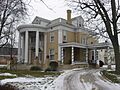
John S. Bowers House
The John S. Bowers House is a historic home found at 104 Marshall Street in Decatur, Indiana. Old houses like this often show us how people lived and what kind of architecture was popular a long time ago. This house was recognized as historic in 1982.
Ceylon Covered Bridge
The Ceylon Covered Bridge is a beautiful old bridge that crosses the Wabash River. It's located in Limberlost County Park, northeast of Ceylon, in Wabash Township. Covered bridges are special because they are becoming quite rare, and they remind us of older ways of building and traveling. This bridge was added to the list in 2007.
Ben Colter Polygonal Barn
The Ben Colter Polygonal Barn is a unique type of barn. It's not shaped like a typical rectangular barn; instead, it has many sides, making it "polygonal." This barn is located on the eastern side of State Road 101 in St. Marys Township. Polygonal barns are interesting examples of farm architecture from the past. It was listed in 1993.
Charles Dugan House
Another historic home in Decatur, Indiana is the Charles Dugan House, located at 420 West Monroe Street. Like the John S. Bowers House, this building helps us understand the history and style of homes in the area. It became a protected historic site in 2009.
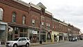
Geneva Downtown Commercial Historic District
The Geneva Downtown Commercial Historic District is not just one building, but a whole area of historic shops and businesses in downtown Geneva, Indiana. It includes buildings along East Line Street. Historic districts show us what a town's main street looked like in earlier times and how communities grew. This district was added to the list in 2002.
Grand Rapids and Indiana Railroad Depot
The Grand Rapids and Indiana Railroad Depot is an old train station located at 111 North 7th Street in Decatur, Indiana. Train depots were once very busy places, connecting towns and people across the country. They are important reminders of how transportation has changed. This depot was listed in 2017.
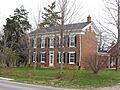
Lenhart Farmhouse
The Lenhart Farmhouse is a historic farm home located at 6929 North Piqua Road, north of Decatur, Indiana, in Root Township. Farmhouses like this tell the story of farming life and the agricultural history of the region. It was added to the National Register in 2002.
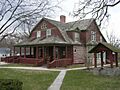
Gene Stratton Porter Cabin
The Gene Stratton Porter Cabin is a very special place located at 200 East 6th Street in Geneva, Indiana. This was the home of Gene Stratton-Porter, a famous American author, naturalist, and photographer. Her work often focused on the natural world around her home. This cabin was recognized as historic in 1974.
Images for kids
-
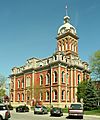
The Adams County Courthouse in Decatur.
-
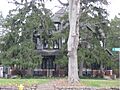
The historic John S. Bowers House.
-
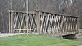
The Ceylon Covered Bridge over the Wabash River.
-
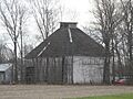
The unique Ben Colter Polygonal Barn.
-
The Charles Dugan House in Decatur.
-
A view of the Geneva Downtown Commercial Historic District.
-
The Lenhart Farmhouse.
-
The Gene Stratton Porter Cabin, also known as Limberlost.


