
National Register of Historic Places listings in Allegany County, New York facts for kids

Have you ever wondered about old buildings and places that are super important to history? In Allegany County, New York, there are many special spots that are listed on the National Register of Historic Places. This is like a special list kept by the United States government. It helps protect buildings, sites, and objects that tell us a lot about the past. When a place is on this list, it means it's recognized for its historical, architectural, or archaeological importance. Let's explore some of these amazing places in Allegany County!
Contents
- What is the National Register of Historic Places?
- Historic Places in Allegany County
- Alfred Village Historic District
- Alumni Hall at Alfred University
- Angelica Park Circle Historic District
- Belmont Grange No. 1243
- Belmont Hotel
- Belvidere Mansion
- Caneadea Bridge
- Centerville Town Hall
- Cuba Cemetery
- Fireman's Hall in Alfred
- Friendship Free Library
- Main Street Historic District in Cuba
- Old Allegany County Courthouse
- Rail and Titsworth Canal Warehouse
- South Street Historic District in Cuba
- Allen Steinheim Museum
- Terra Cotta Building
- US Post Office-Wellsville
- Moses Van Campen House
- Wellsville Erie Depot
- Images for kids
What is the National Register of Historic Places?
The National Register of Historic Places is the official list of the nation's historic places worth saving. It's part of a program to coordinate and support public and private efforts to identify, evaluate, and protect America's historic and archaeological resources. Think of it as a Hall of Fame for old buildings and important sites!
Why are these places important?
These historic places help us understand how people lived long ago. They show us different styles of buildings, how towns grew, and what was important to communities in the past. Protecting them means future generations can also learn from and enjoy these pieces of history.
Historic Places in Allegany County
Allegany County is full of interesting history, and many of its buildings and areas are on the National Register. Here are some examples of these special places:
Alfred Village Historic District
The Alfred Village Historic District was added to the list in 1985. It includes many streets in the village of Alfred, like North and South Main Street. This area shows what a village looked like in the past, with many old buildings that have been preserved.

Alumni Hall at Alfred University
Also in Alfred, Alumni Hall at Alfred University is a significant building. It was listed in 1985. This hall is an important part of the university's history and its beautiful campus.

Angelica Park Circle Historic District
In the village of Angelica, you'll find the Angelica Park Circle Historic District. This district, listed in 1978, includes Main and White Streets and the Allegany County Fairgrounds. It's special because it shows a unique town layout with a central park circle, which was a popular design in the early 1800s.
Belmont Grange No. 1243
The Belmont Grange No. 1243 is located in Belmont. It was added to the Register in 2006. Granges were important community centers for farmers and their families. This building tells us about the social life and farming history of the area.

Belmont Hotel
The Belmont Hotel, listed in 2001, is another historic building in Belmont. Old hotels like this were once busy places where travelers would stay and locals would gather. It's a reminder of how people traveled and socialized in earlier times.

Belvidere Mansion
Belvidere is a grand old mansion located north of Belmont. It was listed way back in 1972. This large estate gives us a peek into the lives of wealthy families in the past and the architectural styles they preferred.
.jpg)
Caneadea Bridge
Bridges can be historic too! The Caneadea Bridge crosses the Genesee River in Caneadea. Listed in 1998, this bridge is important for its engineering and how it helped connect communities.

Centerville Town Hall
The Centerville Town Hall in Centerville was added to the Register in 2009. Town halls are often central to a community's life, serving as places for meetings, voting, and local government. This building represents the civic history of Centerville.

Cuba Cemetery
Even cemeteries can be historic sites! The Cuba Cemetery in Cuba was listed in 2015. It's an old cemetery from 1841 that later joined with a Catholic cemetery. It holds the graves of many early residents of the town, telling stories of the people who built the community.
Fireman's Hall in Alfred
The Fireman's Hall in Alfred, listed in 1980, is another important building. Fire halls often served as community hubs, not just for firefighters but also for social events and gatherings.

Friendship Free Library
The Friendship Free Library in Friendship was listed in 2008. Libraries are crucial for education and community learning, and this building shows the history of how people accessed books and knowledge in the past.

Main Street Historic District in Cuba
The Main Street Historic District in Cuba was listed in 1999. This area includes many buildings along Main Street, showing the historic downtown area and how businesses and homes were arranged.

Old Allegany County Courthouse
The Old Allegany County Courthouse in Angelica is a very old and important building, listed in 1972. Courthouses are where laws were made and justice was served, making this building a key part of the county's legal and political history.

Rail and Titsworth Canal Warehouse
In Belfast, the Rail and Titsworth Canal Warehouse was listed in 2000. This warehouse is a reminder of the importance of canals and railroads for transporting goods in the past, showing how trade and industry developed in the region.

South Street Historic District in Cuba
Another historic district in Cuba is the South Street Historic District, listed in 1988. This area features many historic homes and buildings along South Street.

Allen Steinheim Museum
The Allen Steinheim Museum on the Alfred University Campus was listed in 1973. Museums are places where history and artifacts are preserved and displayed, making this building important for learning about the past.

Terra Cotta Building
The Terra Cotta Building in Alfred, listed in 1972, is known for its unique architectural style. Terra cotta is a type of baked clay used for decoration, and this building is a great example of its use.

US Post Office-Wellsville
The US Post Office-Wellsville in Wellsville was listed in 1989. Post offices were vital for communication and connecting communities before the internet and cell phones.

Moses Van Campen House
The Moses Van Campen House in Angelica was listed in 2004. This house belonged to Moses Van Campen, a notable figure in local history. Historic homes often tell stories of important people and their lives.

Wellsville Erie Depot
The Wellsville Erie Depot in Wellsville was listed in 1987. Train depots were once bustling centers of travel and trade, connecting towns and cities across the country. This depot is a reminder of the golden age of railroads.

Images for kids
-
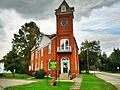
The Belmont Literary and Historical Society Free Library.
-
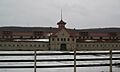
McKinney Stables of Empire City Farms.


