Cuba (village), New York facts for kids
Quick facts for kids
Cuba, New York
|
|
|---|---|
|
Village
|
|

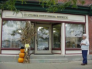
The Cuba Historical Society in Cuba
|
|
| Country | United States |
| State | New York |
| County | Allegany |
| Town | Cuba |
| Area | |
| • Total | 1.22 sq mi (3.15 km2) |
| • Land | 1.22 sq mi (3.15 km2) |
| • Water | 0.00 sq mi (0.00 km2) |
| Elevation | 1,496 ft (456 m) |
| Population
(2020)
|
|
| • Total | 1,517 |
| • Density | 1,247.53/sq mi (481.49/km2) |
| Time zone | UTC-5 (Eastern (EST)) |
| • Summer (DST) | UTC-4 (EDT) |
| ZIP code |
14727
|
| Area code(s) | 585 |
| FIPS code | 36-19356 |
| GNIS feature ID | 0947911 |
Cuba is a small village in Allegany County, New York, United States. In 2020, about 1,517 people lived there. The village is located in the western part of the larger town of Cuba. It sits where two roads, Route 305 and Route 446, meet on Oil Creek.
Contents
History of Cuba
Long ago, a missionary mentioned a natural oil spring in this area. The village of Cuba officially became a village in 1850.
Some important historical places in Cuba are listed on the National Register of Historic Places. These include the Cuba Cemetery, the Main Street Historic District, and the South Street Historic District. These places help preserve the village's past.
Geography of Cuba
Cuba is located in Allegany County. It's just east of the border with Cattaraugus County.
The village covers about 3.15 square kilometers (1.22 square miles) of land. There isn't much water within the village itself, only a few small streams. However, a much larger body of water called Cuba Lake is about 3.2 kilometers (2 miles) north of the village.
A major highway, the Southern Tier Expressway (also known as Interstate 86 and New York State Highway 17), runs along the north side of the village. You can get to Cuba from Exit 28. NY Route 446 runs next to this expressway. NY Route 305 is another important road that goes through the village from north to south. Cuba is also on the main railway line of the Western New York and Pennsylvania Railroad.
You might also hear about North Cuba and South Cuba. These are small communities located north and south of the village along Route 305.
Interesting Places to Visit
South Street Historic District
The South Street Historic District is a special area that covers about four blocks of South Street (Route 305). This street is known for having some of the village's most beautiful homes. It was added to the State and National Historic Registers in 1988, meaning it's protected for its historical importance.
Story Block Building
Inside the historic district, you'll find the Story Block building. It was built by James Story in 1876. This old building is currently being renovated, which means it's getting fixed up and made new again.
Liberty Pole
On the main street, there's a very tall flag pole, about 46 meters (150 feet) high. It flies a huge flag that is 8.5 by 11.5 meters (28 by 38 feet)! This pole was put up in August 2009. At the time, only one other pole east of the Mississippi River, located in Baltimore, Maryland, was as tall. The flag was first raised on September 11, 2009. Before it came to Cuba, this special flag flew over the Capitol Building in Washington, D.C..
Willow Street Walking Bridge
The Willow Street Walking Bridge is a bridge on Willow Street that is just for people to walk across. It's a nice spot for a stroll.
Population Information
| Historical population | |||
|---|---|---|---|
| Census | Pop. | %± | |
| 1880 | 1,251 | — | |
| 1890 | 1,386 | 10.8% | |
| 1900 | 1,502 | 8.4% | |
| 1910 | 1,556 | 3.6% | |
| 1920 | 1,611 | 3.5% | |
| 1930 | 1,422 | −11.7% | |
| 1940 | 1,699 | 19.5% | |
| 1950 | 1,783 | 4.9% | |
| 1960 | 1,949 | 9.3% | |
| 1970 | 1,735 | −11.0% | |
| 1980 | 1,739 | 0.2% | |
| 1990 | 1,690 | −2.8% | |
| 2000 | 1,633 | −3.4% | |
| 2010 | 1,575 | −3.6% | |
| 2020 | 1,517 | −3.7% | |
| U.S. Decennial Census | |||
As of the 2020 census, 1,517 people lived in Cuba. The population has changed over the years, as shown in the table above.
See also
 In Spanish: Cuba (villa) para niños
 | Mary Eliza Mahoney |
 | Susie King Taylor |
 | Ida Gray |
 | Eliza Ann Grier |


