
National Register of Historic Places listings in Beaufort County, South Carolina facts for kids

Beaufort County, South Carolina, is a place rich in history! It's home to many special buildings, sites, and areas that are listed on the National Register of Historic Places. This list helps protect and celebrate important parts of American history.
The National Register of Historic Places is like a special club for buildings, places, and districts across the United States. When a place is added to this list, it means it's important to the history, architecture, archaeology, engineering, or culture of our country. In Beaufort County, there are 76 such places, and 5 of them are even more special, called National Historic Landmarks! These landmarks are considered to be of national importance.
This article will tell you about some of these amazing historic places in Beaufort County.
Contents
What is the National Register of Historic Places?
The National Register of Historic Places is the official list of the nation's historic places worth saving. It's part of a program run by the National Park Service. This program helps people understand and appreciate the history of their communities and the country.
When a place is listed, it gets special recognition. It also means that certain rules apply to help protect it from being changed or destroyed, especially if federal money or permits are involved. It's a way to make sure these important sites are around for future generations to learn from and enjoy.
Cool Historic Places in Beaufort County
Beaufort County has a wide variety of historic places, from old homes and churches to important battle sites and archaeological digs. Here are just a few examples:
Historic Homes and Buildings
Many old homes in Beaufort County tell stories of the past.
The Anchorage
The Anchorage is a beautiful historic house located at 1103 Bay Street in Beaufort. It was built a long time ago and is known for its unique architecture. Imagine living in a house that has seen so much history!

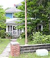
William Barnwell House
Another interesting home in Beaufort is the William Barnwell House at 800 Prince Street. This house was built in the early 1800s and shows us what homes looked like back then.

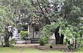
John A. Cuthbert House
The John A. Cuthbert House, found at 1203 Bay Street, is another example of Beaufort's historic architecture. It was built in the 1810s and is a great example of the style of homes from that period.
.jpg)
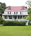
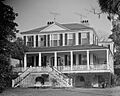
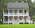
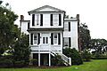
Robert Smalls House
The Robert Smalls House at 511 Prince Street in Beaufort is a very important National Historic Landmark. Robert Smalls was an amazing person who was born into slavery but became a hero during the American Civil War. He famously steered a Confederate ship to freedom and later became a United States Congressman. His home is a powerful reminder of his incredible life and achievements.
.jpg)
Tabby Manse
The Tabby Manse, located at 1211 Bay Street, is special because it's built using "tabby" construction. Tabby is an old building material made from oyster shells, lime, sand, and water. It was often used in coastal areas like Beaufort. This house shows how people built homes with the materials they had available long ago.
.jpg)
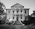
John Mark Verdier House
The John Mark Verdier House at 801 Bay Street is another significant building in Beaufort. It's a great example of Federal-style architecture and played a role during the Civil War. It was used as a headquarters by Union forces.
.jpg)
Historic Districts and Communities
Some entire areas are recognized for their historical importance.
Beaufort Historic District
The Beaufort Historic District is a large area in Beaufort that includes many historic buildings and streets. It's a National Historic Landmark because it shows how a Southern port town developed over centuries. Walking through this district is like stepping back in time!
.jpg)
Bluffton Historic District
The Bluffton Historic District is another important area, located in Bluffton. This district is known for its charming old buildings and its connection to the May River. It gives us a glimpse into the town's past as a summer retreat.

Daufuskie Island Historic District
Daufuskie Island is southwest of Hilton Head and is recognized as a historic district. This island has a unique history, including its Gullah culture, which is a blend of West African and American traditions. The Haig Point Lighthouse is one of its notable features.

Penn Center Historic District
The Penn Center Historic District, south of Frogmore, is a very important National Historic Landmark. It was one of the first schools in the South for formerly enslaved people, established during the Civil War. It became a vital center for education and civil rights, even hosting meetings for Dr. Martin Luther King Jr. It's a powerful symbol of freedom and learning.
.jpg)
Important Sites and Structures
Beaufort County also has many other significant historic places.
Beaufort National Cemetery
The Beaufort National Cemetery is a solemn and important place where many soldiers, including those from the Civil War, are buried. It's a place of honor and remembrance.

Church of the Cross
The Church of the Cross in Bluffton is a beautiful historic church built in the mid-1800s. Its Gothic Revival style makes it a striking landmark along the May River.
.jpg)
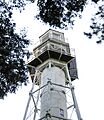
Hunting Island State Park Lighthouse
The Hunting Island Lighthouse is a historic lighthouse located on Hunting Island. It was built in the late 1800s to guide ships safely along the coast. You can even climb to the top for amazing views!

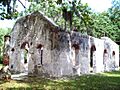
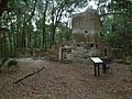
Sheldon Church Ruins
The Sheldon Church Ruins, northwest of Gardens Corner, are the remains of a beautiful church that was burned during the Revolutionary War and again during the Civil War. Even as ruins, it's a powerful and beautiful reminder of the past.
,_Sheldon_vicinity_(Beaufort_County,_South_Carolina).jpg)
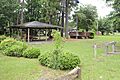
Fort Fremont Battery
Fort Fremont Battery is a historic military site near Frogmore. It was built around the turn of the 20th century to defend the coast during the Spanish-American War. You can explore the remains of the concrete gun batteries.

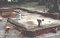
Sams Plantation Complex Tabby Ruins
On Dataw Island, you can find the Sams Plantation Complex Tabby Ruins. These are the remains of a plantation built with "tabby" material in the late 1700s or early 1800s. It gives us a look into the plantation era and the unique building methods used then.

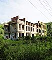
Callawassie Sugar Works
The Callawassie Sugar Works in Okatie are the ruins of an old sugar mill. This site tells us about the agricultural history of the area and how sugar was produced long ago.

Cherry Hill School
The Cherry Hill School on Hilton Head Island is a historic school building. It represents the history of education in the area, especially for African American children during a time of segregation.

Fort Howell
Fort Howell, on Hilton Head Island, is a Civil War earthwork fortification. It was built in 1864 by African American soldiers of the 32nd United States Colored Infantry Regiment and the 144th New York Infantry. It's an important site for understanding the role of African American troops in the war.
Knights of Wise Men Lodge
The Knights of Wise Men Lodge on St. Helena Island is a historic building that served as a meeting place for a fraternal organization. These lodges were important community centers for African Americans, providing support and social gatherings.

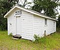
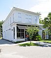
Port Royal School
The Port Royal School, located at 1214 Paris Avenue, is a historic school building in Port Royal. It played a role in the education of children in the community for many years.
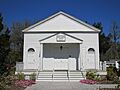
Union Church of Port Royal
The Union Church of Port Royal, at 1004 11th Street, is a historic church that reflects the religious and community life of Port Royal. It's a place where people gathered for worship and social events.

Images for kids
-
Emanuel Alston House
-

Altamaha Town (address restricted)
-
Dr. York Bailey House
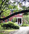
-
Barnwell-Gough House
-
Camp Saxton Site (address restricted)
-
Charlesfort-Santa Elena Site
-
Chester Field (address restricted)
-
Coffin Point Plantation
-
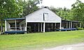
The Corner Packing Shed
-
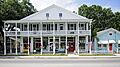
The Corner Store and Office
-

Eddings Point Community Praise House
-
Fish Haul Archaeological Site (address restricted)
-
Fort Frederick Heritage Preserve (address restricted)
-
Fort Fremont Hospital
-
Fort Lyttelton Site (address restricted)
-
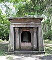
Edgar Fripp Mausoleum
-

Barn at Frogmore Plantation Complex
-
Green's Shell Enclosure (address restricted)
-
The Green
-
Hasell Point Site (address restricted)
-
Indian Hill Site (address restricted)
-
Mary Jenkins Community Praise House
-
Lands End Road Tabby Ruins (address restricted)
-
Laurel Bay Plantation (address restricted)
-
Marshlands
-
McLeod Farmstead
-
Auldbrass Plantation
-
Pocosobo Town (address restricted)
-
Rear Lighthouse of Hilton Head Range Light Station
-
Rose Hill Plantation House
-
St. Helena Parish Chapel of Ease Ruins
-
St. Helenaville Archaeological Site (address restricted)
-
St. Luke's Church
-
F.W. Scheper Store
-
Seacoast Packing Company
-
Skull Creek (address restricted)
-
SS William Lawrence Shipwreck Site (address restricted)
-
Stoney-Baynard Plantation
-
Tombee Plantation


.jpg)
.jpg)


.jpg)


.jpg)


.jpg)


