
National Register of Historic Places listings in Brown County, South Dakota facts for kids

Have you ever wondered about the oldest and most special buildings or places in your area? In Brown County, South Dakota, there's a list of these amazing spots! It's called the National Register of Historic Places listings in Brown County, South Dakota. This list helps protect and celebrate places that are important to history, architecture, or culture in the county.
There are 45 properties and areas in Brown County that are currently on this special list. One other place was on the list but has since been removed. You can even see some of these places on a map if their exact location is shared!
Contents
What is the National Register of Historic Places?
The National Register of Historic Places is like a hall of fame for important places in the United States. It's the official list of the nation's historic places that are worth saving. When a building, site, structure, object, or district is added to the Register, it means it has special meaning. This could be because of its history, its unique design, or what it represents about American culture.
Being on the Register helps to:
- Recognize and celebrate important places.
- Encourage people to protect and preserve these sites.
- Sometimes, it can even help with getting money to fix up and maintain these historic treasures.
Cool Historic Places in Brown County
Brown County has many interesting places on the National Register. Let's explore a few of them!
Historic Districts in Aberdeen
Aberdeen, the biggest city in Brown County, has several areas that are considered historic districts. This means a whole group of buildings in that area is important together.
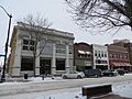
Aberdeen Commercial Historic District
This district includes many buildings along South Main Street in Aberdeen. It's where a lot of businesses have been for a long time. Imagine walking down this street and seeing buildings that have stood there for over a hundred years! The First National Bank building is one example of the cool architecture you might see here. It was added to the list in 1988.
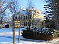
Aberdeen Highlands Historic District
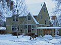
This area is found on North Main Street. It's a neighborhood with many older homes and buildings that show how Aberdeen grew over time. It became a historic district in 1975.
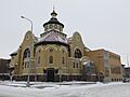
Aberdeen Historic District
Another important area in Aberdeen, this district covers parts of 3rd to 6th Avenues and some nearby streets. It includes places like the First Presbyterian Church, which is a beautiful old building that tells a story about the community's past. This district was also listed in 1975.
Important Buildings and Churches
Many individual buildings in Brown County are also recognized for their historical value.
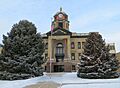
Brown County Courthouse
Located on 1st Avenue in Aberdeen, the Brown County Courthouse is a grand building where important decisions for the county have been made for many years. It was built with a classic design and has been a landmark since 1976.
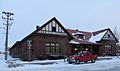
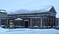
Chicago, Milwaukee, St. Paul and Pacific Railroad Depot
Train stations were once super important hubs for travel and trade. The Chicago, Milwaukee, St. Paul and Pacific Railroad Depot on Main Street and Railroad Avenue in Aberdeen is a great example of this. It reminds us of a time when trains were the main way people and goods moved across the country. It was listed in 1977.
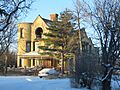
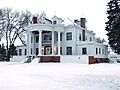
Easton's Castle
Yes, Brown County even has a "castle"! Easton's Castle is a unique house located at 1210 2nd Avenue, NW, in Aberdeen. It has a very distinct look that makes it stand out. It was added to the Register in 1973.
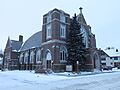
First United Methodist Church
Churches often play a big role in a community's history. The First United Methodist Church on S. Lincoln Street and SE. 5th Avenue in Aberdeen is one such place. Its architecture and long history make it a significant landmark, listed in 1976.
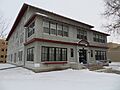
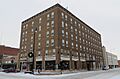
Alonzo Ward Hotel
The Alonzo Ward Hotel at 104 S. Main Street in Aberdeen was once a very fancy place for travelers to stay. Hotels like this were important social centers in the past. It was recognized for its history in 1982.
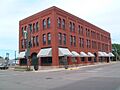
Western Union Building
The Western Union Building at 21-23 S. Main Street in Aberdeen was a key place for communication before cell phones and the internet. Western Union was famous for sending telegrams, which were quick messages sent over wires. This building reminds us of how people used to connect. It was listed in 1976.
Rural Historic Sites
It's not just cities that have historic places! Brown County's countryside also holds important sites.
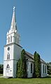
Augustana Swedish Lutheran Church
This church, located south of Claremont, shows the history of Swedish settlers in the area. Churches like this were often the heart of immigrant communities, providing a place for worship and gathering. It was listed in 1988.
Aurland United Norwegian Lutheran Church
Southeast of Frederick, this church tells the story of Norwegian settlers. These rural churches are important reminders of the different groups of people who helped build South Dakota. It was added in 1982.
Savo Hall-Finnish National Society Hall
Northeast of Savo, this hall was a gathering place for the Finnish community. It's a great example of how different immigrant groups created their own social centers. It was listed in 1985.
Plana School
Schools are important parts of a community's history. The Plana School building, located north of Highway 12 near Plana, represents the history of education in rural Brown County. It was listed in 1995.
Welsh Presbyterian Church
Also near Plana, the Welsh Presbyterian Church highlights the presence of Welsh settlers in the area. These churches often served as cultural centers, keeping traditions alive. It was listed in 1995.
Bridges and Other Structures
Even bridges can be historic! Several bridges in Brown County are on the Register because of their engineering or their role in connecting communities.
South Dakota Dept. of Transportation Bridge No. 07-268-030
This bridge, located near Hecla, crosses the James River. It's recognized for its design and its importance in transportation. It was listed in 2000.
Former Listing
Sometimes, a place that was once on the National Register might be removed. This usually happens if the place changes so much that it no longer has its historic value, or if it's replaced.
South Dakota Dept. of Transportation Bridge No. 07-091-330
This bridge, which carried US 12 over railroad tracks near Aberdeen, was listed in 2000. However, it was later replaced in 2005 and removed from the Register in 2008 because it no longer existed in its original historic form.
Images for kids
-
Aberdeen Commercial Historic District
-
Aberdeen Highlands Historic District
-
Aberdeen Historic District
-
Augustana Swedish Lutheran Church
-
Brown County Courthouse
-
Brown Hall
-
Chicago, Milwaukee, St. Paul and Pacific Railroad Depot
-
Easton's Castle
-
First United Methodist Church
-
Foght-Murdy House
-
Great Northern Railway Passenger and Freight Depot
-
Masonic Temple
-
Minneapolis and St. Louis Railroad Depot
-
Simmons House
-
Alonzo Ward Hotel
-
Western Union Building


