
National Register of Historic Places listings in Caroline County, Maryland facts for kids

Did you know that many old buildings and places in the United States are considered super important? They are listed on something called the National Register of Historic Places. This special list helps protect places that tell us about history, architecture, or culture.
In Caroline County, Maryland, there are 23 amazing places that are on this list! These include old houses, schools, churches, and even whole neighborhoods. Each one has a unique story to tell about the past of Caroline County.
Contents
What are Historic Places?
The National Register of Historic Places is like a hall of fame for important buildings, sites, and objects. It's managed by the National Park Service. When a place is added to this list, it means it's recognized for its special history. This helps people understand and protect these places for future generations.
Being on the Register doesn't stop people from changing a property. But it does encourage them to preserve its historic features. It also makes some places eligible for grants or tax benefits to help with preservation.
Exploring Caroline County's History
Caroline County is full of history, and its listed places show us different parts of its past. From old mills to grand homes, these sites offer a peek into how people lived and worked long ago.
Cool Historic Buildings
Many individual buildings in Caroline County are on the National Register. These include homes, churches, and even an old armory.
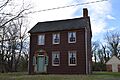
- Castle Hall: This historic home near Goldsboro was listed in 1975. It's a great example of older architecture in the area.
- Denton Armory: Located in Denton, this building was added to the list in 1985. An armory is a place where military equipment is stored, or where soldiers train. This one has a unique design.
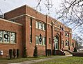
- Denton Schoolhouse: Also in Denton, this old schoolhouse became a historic site in 1978. Imagine learning your ABCs in a building like this!
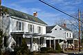
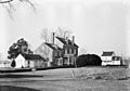
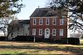
- Exeter: This property near Federalsburg was listed in 1978. It's another important historic home.
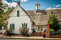
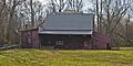
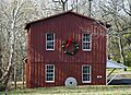
- Linchester Mill: Found in Preston, this mill was added to the Register in 2009. Mills were super important in the past for grinding grain.
- Memory Lane: This unique property in Denton was listed in 2000. It's a reminder of how places can hold special memories.
- Nanticoke Lodge No. 172, A.F. and A.M.: This lodge in Federalsburg was listed in 2014. Lodges are meeting places for groups like the Freemasons.
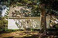
- Neck Meetinghouse and Yard: Near West Denton, this meetinghouse was listed in 1976. Meetinghouses were often used for religious gatherings.
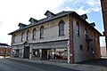
- Potter Hall: Located in Williston, this hall was recognized in 1982. It's another example of historic architecture.
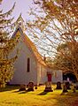
- St. Paul's Episcopal Church: This beautiful church in Hillsboro was listed in 1975. Churches often have long histories and beautiful designs.
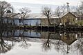
- West Denton Warehouse-Wharf: This site in West Denton was listed in 2000. It shows the importance of water travel and trade in the past.
- Willow Grove: Near Greensboro, this property was added to the Register in 1972. It's one of the older listings in the county.
Historic Neighborhoods and Areas
Sometimes, it's not just one building that's historic, but a whole group of buildings or a neighborhood. These are called "historic districts."
- Denton Historic District: A large part of downtown Denton is recognized as a historic district. This means many buildings in that area are important together. It was listed in 1983.
- Federalsburg West Historic District: This area in Federalsburg was listed in 2016. It includes a collection of buildings that show the town's growth.
- Williston Mill Historic District: Near Denton, this district includes the historic mill and other nearby structures. It was listed in 2002.
These districts help us see how towns developed over time. They show different styles of buildings and how communities were planned.
Images for kids
-

Location of Caroline County in Maryland
-

Castle Hall
-
Denton Armory
-
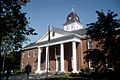
Caroline County Courthouse, part of the Denton Historic District
-
Denton Schoolhouse
-
Exeter
-
Bloomingdale Avenue in the Federalsburg West Historic District
-
Linchester Mill
-

Memory Lane
-
Nanticoke Lodge No. 172, A.F. and A.M.
-
Neck Meetinghouse and Yard
-
Potter Hall
-
St. Paul's Episcopal Church
-
West Denton Warehouse-Wharf
-
Williston Mill
-
Willow Grove


