
National Register of Historic Places listings in Catawba County, North Carolina facts for kids

Have you ever wondered about the old buildings and places in your town? In Catawba County, North Carolina, there are many special spots that are so important, they've been added to a list called the National Register of Historic Places. This list helps protect buildings, structures, and areas that tell us a lot about the past. It's like a hall of fame for historic places!
When a place is on this list, it means it's recognized for its history, amazing architecture, or for being important to local culture. Let's explore some of these cool historic places in Catawba County!
Contents
Historic Treasures in Catawba County
Catawba County is full of places that have stood the test of time. These sites help us understand how people lived, worked, and built communities long ago.
Bunker Hill Covered Bridge
One of the most famous historic places is the Bunker Hill Covered Bridge. Imagine a time when most bridges were open to the sky. This bridge, built in 1895, is a rare example of a covered bridge in North Carolina. It's located near Claremont and was built to protect the wooden structure from the weather, making it last longer. It's like a cozy tunnel over the water!

Catawba County Courthouse
In Newton, you'll find the Catawba County Courthouse. This grand building was built in 1924 and has been a central part of the county's government and community life for nearly a century. Courthouses are often important because they are where many big decisions and events in a community's history take place.

Libraries and Learning
Libraries have always been important places for learning and community gatherings.
Elliott–Carnegie Library
The Elliott–Carnegie Library in Hickory is a beautiful example of a library built with money from Andrew Carnegie, a famous businessman who helped fund thousands of libraries across the country. Built in 1923, it shows how important reading and education were, even a long time ago.

Ridgeview Public Library
Another important library is the Ridgeview Public Library, also in Hickory. This building, though no longer a library, was a key place for the African American community in Hickory. It served as a center for learning and community activities, showing the importance of access to books and knowledge for everyone.
Historic Homes and Farms
Many historic places are old homes and farms that show us what daily life was like in the past.
Abraham Anthony Farm
The Abraham Anthony Farm near Blackburn is a great example of an old farm. It was listed in 1990 and helps us remember the agricultural history of the area. Farms like this were the heart of communities, providing food and a way of life for many families.

Dr. Glenn R. Frye House
In Hickory, the Dr. Glenn R. Frye House is a significant home built in 1927. It's named after a well-known doctor and shows the architectural styles popular in that era. Homes like this often tell stories of the people who lived there and their contributions to the community.

John Alfred Moretz House
The John Alfred Moretz House, also in Hickory, was built in 1903. It's another example of a historic home that gives us a peek into the lives of prominent families from the early 20th century.

Propst House
The Propst House in Hickory, built around 1880, is a very old home that has been preserved. It's located in the Shuford Memorial Garden, making it a peaceful place to visit and imagine life over a century ago.

Shuford House
Another notable home in Hickory is the Shuford House, built in 1919. This house represents the growth and development of Hickory in the early 20th century, showing the kind of homes built by successful families of the time.

Community and Worship Places
Churches and community centers often hold deep historical meaning.
First Presbyterian Church
The First Presbyterian Church in Hickory, built in 1923, is a beautiful church that has been a spiritual home for many generations. Its architecture and long history make it a special landmark in the city.

St. Paul's Church and Cemetery
Near Newton, the St. Paul's Church and Cemetery was listed in 1971. Churches like this often have long histories, serving as gathering places and spiritual centers for their communities for many years. The cemetery also tells stories of the people who lived and died in the area.

St. Paul's Reformed Church
The St. Paul's Reformed Church in Startown is another historic church, listed in 1990. These old churches are not just buildings; they are symbols of faith and community that have stood strong through many changes.

Balls Creek Campground
The Balls Creek Campground near Bandy's Crossroads is a unique historic district. Campgrounds like this were important for religious gatherings and community events in the past, often featuring old "arbors" or open-air shelters for meetings.

Industrial and Commercial History
Some historic places show us how people worked and how businesses grew.
Murray's Mill Historic District
The Murray's Mill Historic District southeast of Catawba is a fascinating place. It includes an old gristmill, which was used to grind grain into flour. Mills like this were vital for local farmers and communities, showing how goods were produced before modern factories.

Piedmont Wagon Company
In Hickory, the Piedmont Wagon Company building tells the story of early manufacturing. This company made wagons, which were super important for transportation and farming before cars became common. It's a reminder of the industries that helped build the region.

Lyerly Full Fashioned Mill
The Lyerly Full Fashioned Mill in Hickory, listed in 2007, was a textile mill. North Carolina has a rich history in textile production, and this mill represents that important part of the state's industrial past.
Harris Arcade
The Harris Arcade in Hickory, built in 1921, is an example of an early commercial building. Arcades were often covered walkways with shops, a bit like an early version of a shopping mall. It shows how downtown areas developed over time.

Historic Districts
Sometimes, it's not just one building that's historic, but a whole group of buildings or an entire neighborhood. These are called historic districts.
Claremont High School Historic District
The Claremont High School Historic District in Hickory includes the old high school building and surrounding areas. Schools are often central to a community's history, and this district shows how education and neighborhoods grew together.

Kenworth Historic District
The Kenworth Historic District in Hickory is a neighborhood with many historic homes. Walking through such a district is like stepping back in time, seeing the different styles of houses and how communities were planned.

Oakwood Historic District
Another important neighborhood is the Oakwood Historic District in Hickory. It's roughly bounded by Oakwood Cemetery and several streets. Historic districts help preserve the overall look and feel of an older area, keeping its unique character alive.

Hickory Southwest Downtown Historic District
This district covers a part of downtown Hickory. It includes a mix of buildings that show how the city's commercial and civic center developed over the years.

Other Notable Places
There are many other fascinating places on the National Register in Catawba County, each with its own story. These include various farms like the George Huffman Farm and the Wilfong–Wilson Farm, and other unique structures like the Powell–Trollinger Lime Kilns, which were used to produce lime, an important material for building and farming.
Every place on this list helps us understand the rich history of Catawba County and North Carolina!
Images for kids
-
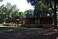
The Lee & Helen George House.
-
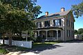
The Clement Geitner House.
-
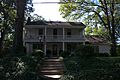
The John A. Lentz House.
-
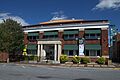
The Hickory Municipal Building.


