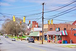
Claremont, North Carolina facts for kids
Quick facts for kids
Claremont, North Carolina
|
|
|---|---|

Main Street (US 70)
|
|

Location of Claremont, North Carolina
|
|
| Country | United States |
| State | North Carolina |
| County | Catawba |
| Area | |
| • Total | 2.85 sq mi (7.38 km2) |
| • Land | 2.85 sq mi (7.38 km2) |
| • Water | 0.00 sq mi (0.00 km2) |
| Elevation | 961 ft (293 m) |
| Population
(2020)
|
|
| • Total | 1,692 |
| • Density | 593.89/sq mi (229.33/km2) |
| Time zone | UTC-5 (Eastern (EST)) |
| • Summer (DST) | UTC-4 (EDT) |
| ZIP code |
28610
|
| Area code(s) | 828 |
| FIPS code | 37-12720 |
| GNIS feature ID | 2404053 |
Claremont is a city located in Catawba County, North Carolina, in the United States. In 2020, about 1,692 people lived there. It is part of a larger area that includes the cities of Hickory, Lenoir, and Morganton.
Contents
History of Claremont
Claremont has had a few different names over time. It was first called Charlotte Crossing, then Setzer Depot. The city started using its current name, Claremont, in 1892. This name came from Clare Sigmon, who was the daughter of one of the first people to settle in the area. The city officially became a city in 1893.
In 2023, a large company called CommScope moved its main office to Claremont. CommScope is a company that builds important parts for internet and communication networks.
Two special places in Claremont are listed on the National Register of Historic Places. This means they are important historical sites that are protected. These places are the Bunker Hill Covered Bridge and Rock Barn Farm.
Geography of Claremont
Claremont is located in the eastern part of Catawba County. A main road, U.S. Route 70, goes right through the middle of the town. This road can take you about 4 miles west to Conover or 4 miles east to Catawba.
Another major highway, Interstate 40, passes just north of Claremont. You can get onto I-40 from Exit 135. From there, it's about 12 miles west to Hickory and 16 miles east to Statesville.
The United States Census Bureau says that Claremont covers an area of about 7.1 square kilometers (or 2.7 square miles). All of this area is land.
People in Claremont
| Historical population | |||
|---|---|---|---|
| Census | Pop. | %± | |
| 1900 | 160 | — | |
| 1910 | 297 | 85.6% | |
| 1920 | 435 | 46.5% | |
| 1930 | 368 | −15.4% | |
| 1940 | 467 | 26.9% | |
| 1950 | 669 | 43.3% | |
| 1960 | 728 | 8.8% | |
| 1970 | 788 | 8.2% | |
| 1980 | 880 | 11.7% | |
| 1990 | 980 | 11.4% | |
| 2000 | 1,038 | 5.9% | |
| 2010 | 1,352 | 30.3% | |
| 2020 | 1,692 | 25.1% | |
| U.S. Decennial Census | |||
The population of Claremont has grown over the years. In 1900, there were only 160 people, but by 2020, the population had grown to 1,692 people.
Claremont's Population in 2020
In 2020, there were 1,692 people living in Claremont. Most of the people living in Claremont were White. There were also people who identified as Black or African American, Asian, and Hispanic or Latino, along with other groups.
There were 685 households and 487 families living in the city. A household means all the people living in one home.
Claremont's Population in 2010
Back in 2010, there were 1,355 people in Claremont. About 27% of the households had children under 18 living with them. Most households were married couples living together.
The average age of people in Claremont was 38 years old. About 20% of the population was under 18 years old.
Famous People from Claremont
Claremont has been home to some interesting people:
- William Harrison Anderson – He was a missionary for the Seventh-day Adventist Church.
- Landon Huffman – He is a stock car racing driver and also a popular YouTuber.
- Robert Huffman – He was a NASCAR driver and won the Goody's Dash Series championship five times.
See also
 In Spanish: Claremont (Carolina del Norte) para niños
 | Audre Lorde |
 | John Berry Meachum |
 | Ferdinand Lee Barnett |

