
National Register of Historic Places listings in Chemung County, New York facts for kids

Chemung County in New York is home to many amazing places that are part of the National Register of Historic Places. This special list includes buildings, sites, and districts that are important to American history, architecture, archaeology, engineering, or culture. When a place is on this list, it means it's recognized for its unique value and efforts are made to protect it.
In Chemung County, you can find many such historic spots, from old houses and churches to schools and even a famous battlefield. One very special place, the Newtown Battlefield, is even called a National Historic Landmark, which is an even higher level of recognition! Let's explore some of these cool places.
Historic Places in Chemung County
Elmira's Historic Buildings
Elmira, a major city in Chemung County, has many buildings with interesting stories.
Old Houses and Homes
- John Brand Jr. House (351 Maple Ave.): This house was added to the list in 2010.
- John Brand Sr. House (405 Maple Ave.): Listed in 2010, this is another historic home on Maple Avenue.
- Alexander Eustace House (401 Maple Ave.): This house, listed in 2012, is also found on Maple Avenue.
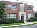
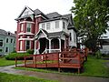
- William S. Gerity House (415 William St.): This historic house was added to the list in 2010.
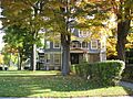
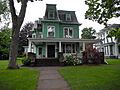
- Pratt House (413 Lake St.): Listed in 2008, this is another significant house in Elmira.
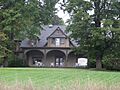
- Quarry Farm (Crane Rd.): Added in 1975, this farm is famous because it was the summer home of the famous writer Mark Twain. He wrote many of his books here!
- John W. Jones House (1250 Davis St.): This house, listed in 2003, was the home of John W. Jones. He was a former enslaved person who escaped to freedom and became an important leader in the Underground Railroad, helping others find freedom. He also cared for the graves of soldiers at Woodlawn Cemetery.
Important Public and Commercial Buildings
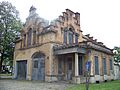
- Buildings at 104-116 West Water St. (104-116 W. Water St.): These buildings were listed in 2008. Sadly, they were taken down in 2014 and 2015.
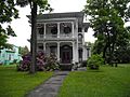
- Chemung Canal Bank Building (415 E. Water St.): Built in 1833, this is the oldest commercial building in Elmira. It was listed in 1978.
- Chemung County Courthouse Complex (210-228 Lake St.): This complex includes several important government buildings like the courthouse and offices. They were built between 1836 and 1899 and listed in 1971.
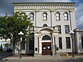
- Elmira Heights Village Hall (268 E. 14th St.): This building in Elmira Heights was built in 1896 and designed by local architects. It was listed in 1982.
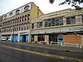
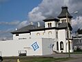
- Elmira Coca-Cola Bottling Company Works (415 W. 2nd St.): This building, built in 1939, has a unique "Art Moderne" style. It's important for its architecture and its role in Elmira's industrial past. It was listed in 1997.
- F. M. Howell and Company (79-105 Pennsylvania Ave.): This company's buildings were listed in 1984.
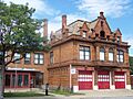
- Fire Station No. 4 (301 Maxwell Pl.): Built in 1897, this fire station was also designed by local architects. It was listed in 1988.
- George Washington School (430 W. Washington Ave.): This Art Deco style school was built in 1939 as a PWA project, which helped create jobs during the Great Depression. It was used as a school until 2006 and listed in 2017.
Historic Churches
- Emmanuel Episcopal Church (380 Pennsylvania Ave.): This church was listed in 1998.
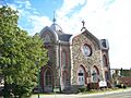
- Erste Deutsche Evangelische Kirche (160 Madison Ave.): Built between 1898 and 1899, this church served a German American community. It was listed in 2007.
- Park Church (208 W. Gray St.): This church was added to the list in 1977.
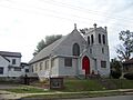
- Pentecostal Holy Temple Church of Jesus Christ (351 Division St.): This church was listed in 1998, but the address is now an empty lot.
- St. Patrick's Parochial Residence-Convent and School (515-517 Park Pl.): These church-related buildings were listed in 1992.
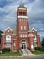
- Trinity Church (304 N. Main St.): Designed by Henry Dudley and built between 1855 and 1858, this church was listed in 2007.
Historic Districts in Elmira
- Clinton–Columbia Historic District: This area has many homes built in the late 1800s and early 1900s when Elmira was growing fast with industries. It was listed in 2015.
- Elmira Civic Historic District: This district was the center of government in early Elmira. It includes the Chemung County Courthouse Complex, the U.S. Post Office, the Armory Building, and City Hall. It was listed in 1980.
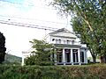
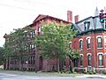
- Elmira College Old Campus: This campus is very important because it was the first college in the U.S. to offer women a degree program similar to those for men. It was listed in 1984.
- Maple Avenue Historic District: This district includes many historic buildings along Maple Avenue and was listed in 2013.
- Near Westside Historic District: This area, near the Chemung River, was listed in 1983.
- North Main and West Water Commercial Historic District: This business area shows how the city grew westward along trolley lines in the late 1800s and early 1900s. It was listed in 2016.
- John W. Jones Court (603-657 Dickinson St.): This area was listed in 2017.
Historic Places in Other Chemung County Towns
Chemung and Lowman
- Chemung District School No. 10 (Old NY 17 at Lowman Rd., Lowman): This old schoolhouse was listed in 2008.
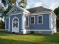
- Dr. Hovey Everett House (1594 Cty Rte 60, Lowman): This house was added to the list in 2007.
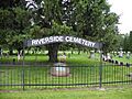
- Riverside Cemetery (County Route 60, Lowman vicinity): This cemetery was listed in 2012.
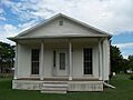
- Christ Episcopal Church (117 Main St., Wellsburg): Designed by Issac O. Perry and built in 1869, this church was listed in 2000.
Horseheads
- Chemung Railway Depot-Horseheads (312 W. Broad St.): Built in 1866, this train station was used until 1956. It was listed in 1996.
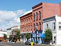
- Hanover Square Historic District (Jct. of E. and W. Franklin and N. and S. Main Sts.): This downtown business area was mostly rebuilt between 1862 and 1882 after a big fire destroyed the town. It was listed in 1982.
- Horseheads 1855 Extension Historic District: This district was listed in 1980.
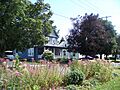
- Teal Park (Steuben, Pine, and W. Main Sts.): This public park has a bandstand designed by the famous political cartoonist Eugene Zimmerman. It was listed in 1983.
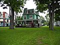
- Zimmerman House (601 Pine St.): This was the home of political cartoonist Eugene Zimmerman. It was listed in 1983.
Big Flats
- Warren E. Eaton Motorless Flight Facility (62 Soaring Hill Dr.): This site, listed in 2013, is important for the early development of American gliding. It's also known as the National Soaring Museum.
Pine City
- Mount Saviour Monastery (231, 121, 122 Monastery & 65, 212 Fisher Hill Rds, Pine City vicinity): This farm has been continuously operating since 1865. After monks bought it in 1950, it changed from growing large amounts of crops to smaller, special crops. It was listed in 2015.
Erin
- Scotchtown Cemetery (NY 223): This cemetery was listed in 2008.
Newtown Battlefield State Park
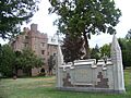
- Newtown Battlefield (6 mi. SE of Elmira on NY 17): This site is a National Historic Landmark and was listed in 1972. It was the location of the only major battle of the Sullivan Expedition during the American Revolutionary War. This expedition was ordered to stop the threat from the Iroquois, who were defeated here.
Woodlawn Cemetery
- Woodlawn Cemetery and Woodlawn National Cemetery (Walnut and Davis Sts., West Hill and Bancroft Rds., Elmira): Listed in 2004, this cemetery is the burial place of many famous people, including writer Mark Twain, football player Ernie Davis, and film producer Hal Roach. The national part of the cemetery started when Confederate prisoners of war from the American Civil War were buried there. John W. Jones, mentioned earlier, was the sexton (caretaker) of this cemetery and helped bury the Confederate soldiers.
Images for kids
-
John Brand Jr. House
-
John Brand Sr. House
-
Buildings at 104-116 West Water St.
-
Chemung Canal Bank Building
-
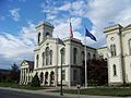
Chemung County Courthouse Complex
-
Chemung District School No. 10
-
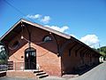
Chemung Railway Depot-Horseheads
-
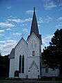
Christ Episcopal Church
-
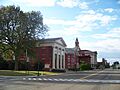
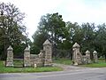
Elmira Civic Historic District
-
Elmira Coca-Cola Bottling Company Works
-
Tompkins Hall at Elmira College
-
Elmira Heights Village Hall
-
Emmanuel Episcopal Church
-
Erste Deutsche Evangelische Kirche
-
Alexander Eustace House
-
Dr. Hovey Everett House
-
Fire Station No. 4
-
William S. Gerity House
-
Hanover Square Historic District
-
Horseheads 1855 Extension Historic District
-
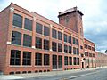
F. M. Howell and Company
-
John W. Jones House
-
Maple Avenue Historic District
-
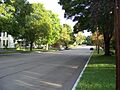
Near Westside Historic District
-
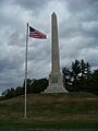
Newtown Battlefield State Park
-
Park Church
-
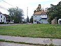
Pentecostal Holy Temple Church of Jesus Christ (empty lot)
-
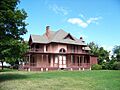
Pratt House
-
Quarry Farm
-
Riverside Cemetery
-
St. Patrick's Parochial Residence-Convent and School
-
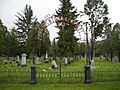
Scotchtown Cemetery
-
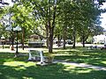
Teal Park
-
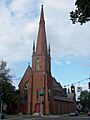
Trinity Church
-
Woodlawn Cemetery
-
Zimmerman House


