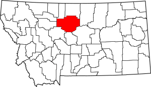
National Register of Historic Places listings in Chouteau County, Montana facts for kids
Have you ever wondered about old buildings and places that are really important to history? In Chouteau County, Montana, there are many special spots that are officially recognized for their historical value. These places are listed on the National Register of Historic Places. This list helps protect and celebrate buildings, sites, and objects that tell us about the past of Montana and the United States.
There are 21 amazing places in Chouteau County that are on this list. One of them is even a National Historic Landmark, which means it's super important to the history of the entire country!
Exploring Chouteau County's Historic Places
Let's take a look at some of the cool historic places you can find in Chouteau County. These sites help us remember the stories and people who shaped this area long ago.
| Name on the Register | Image | Date listed | Location | City or town | Description | |
|---|---|---|---|---|---|---|
| 0 | I.G. Baker House |
(Ref. # missing) |
1604 Front St. Coordinates missing |
Fort Benton | This historic house is located in Fort Benton. | |
| 0 | Chouteau County Courthouse |
(Ref. # missing) |
1308 Franklin St. Coordinates missing |
Fort Benton | This is the main building for the county government in Fort Benton. | |
| 0 | Citadel Rock |
(Ref. # missing) |
East of Fort Benton Coordinates missing |
Fort Benton | A unique rock formation located east of Fort Benton. | |
| 0 | Eagle Butte School |
(Ref. # missing) |
Eagle Butte School Rd., 23 miles off Montana Highway 80 Coordinates missing |
Fort Benton | An old school building that is now a historic site. | |
| 0 | First National Bank of Geraldine |
(Ref. # missing) |
311 Main St. Coordinates missing |
Geraldine | This building was once a busy bank in Geraldine. | |
| 0 | Fort Benton Bridge |
(Ref. # missing) |
Spans the Missouri River Coordinates missing |
Fort Benton | This bridge crosses the famous Missouri River. | |
| 0 | Fort Benton Engine House |
(Ref. # missing) |
Front and 15th Sts. Coordinates missing |
Fort Benton | An old engine house in Fort Benton. | |
| 0 | Fort Benton Historic District |
(Ref. # missing) |
Front St. (1220 through 1900 block) levee, and bridge Coordinates missing |
Fort Benton | This whole area in Fort Benton is a National Historic Landmark because it's so important to the history of the American West. | |
| 0 | Geraldine Milwaukee Depot |
(Ref. # missing) |
Railroad Ave., approximately 10 miles south of Montana Highway 80 Coordinates missing |
Geraldine | An old train station in Geraldine. | |
| 0 | Grand Union Hotel |
(Ref. # missing) |
14th and Front Sts. Coordinates missing |
Fort Benton | A grand old hotel in Fort Benton. | |
| 0 | Judith Landing Historic District |
(Ref. # missing) |
Address Restricted |
Winifred | This historic area extends into Fergus County. | |
| 0 | Lewis and Clark Camp at Slaughter River |
(Ref. # missing) |
40 miles south of the Big Sandy River on the Missouri River Coordinates missing |
Big Sandy | A campsite used by the famous explorers Lewis and Clark. | |
| 0 | Lonetree |
(Ref. # missing) |
South of Geraldine Coordinates missing |
Geraldine | A historic site located south of Geraldine. | |
| 0 | Masonic Building |
(Ref. # missing) |
1418 Front St. Coordinates missing |
Fort Benton | This building in Fort Benton has historical importance. | |
| 0 | St. Paul's Episcopal Church |
(Ref. # missing) |
14th and Chouteau Sts. Coordinates missing |
Fort Benton | A historic church in Fort Benton. | |
| 0 | Shonkin Creek Bridge |
(Ref. # missing) |
Approximately mile 21 on Shonkin Rd. Coordinates missing |
Geraldine vicinity | This bridge is part of a special group of historic bridges in Montana. | |
| 0 | Square Butte Jail |
(Ref. # missing) |
Salsbury Ave. Coordinates missing |
Square Butte | The old jail building in Square Butte. | |
| 0 | Square Butte School |
(Ref. # missing) |
Northwest corner of Diederick St. and Broadway Coordinates missing |
Square Butte | A historic school building in Square Butte. | |
| 0 | Teton River Crossing on the Whoop-Up Trail |
(Ref. # missing) |
Address Restricted |
Carter | This site marks a historic crossing point on an old trail. | |
| 0 | Virgelle Mercantile and Virgelle State Bank |
(Ref. # missing) |
County Road 430, approximately 6.3 miles south of U.S. Route 87 Coordinates missing |
Virgelle | These two buildings in Virgelle are important historic structures. | |
| 0 | West Quincy Granite Quarry |
(Ref. # missing) |
Flat Creek Rd. Coordinates missing |
Square Butte | An old granite quarry near Square Butte. |
Places No Longer Listed
Sometimes, a historic place might be removed from the National Register. This can happen if the building is changed too much or if it's no longer there.
| Name on the Register | Image | Date listed | Date removed | Location | City or town | Summary | |
|---|---|---|---|---|---|---|---|
| 0 | Chouteau County Jail |
(Ref. # missing) |
Washington and Fourteenth Sts. Coordinates missing |
Fort Benton | This old jail in Fort Benton was once on the list but has since been removed. |


