National Register of Historic Places listings in Cloud County, Kansas facts for kids
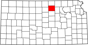
This is a list of the National Register of Historic Places listings in Cloud County, Kansas.
This is intended to be a complete list of the properties and districts on the National Register of Historic Places in Cloud County, Kansas, United States. The locations of National Register properties and districts for which the latitude and longitude coordinates are included below, may be seen in a map.
There are 10 properties and districts listed on the National Register in the county.
Current listings
| Name on the Register | Image | Date listed | Location | City or town | Description | |
|---|---|---|---|---|---|---|
| 1 | Bankers Loan and Trust Company Building |
(#77000576) |
101 E. 6th and 517 Broadway 39°34′18″N 97°39′31″W / 39.571667°N 97.658611°W |
Concordia | ||
| 2 | Brown Grand Opera House |
(#73000747) |
310 W. 6th St. 39°34′17″N 97°39′46″W / 39.571389°N 97.662778°W |
Concordia | ||
| 3 | Clyde School |
(#08001348) |
620 Broadway St. 39°35′25″N 97°24′11″W / 39.590244°N 97.403022°W |
Clyde | ||
| 4 | County Line Bowstring |
(#89002192) |
Over West Creek, northwest of Hollis 39°39′12″N 97°34′21″W / 39.653333°N 97.5725°W |
Hollis | ||
| 5 | Glasco Downtown Historic District |
(#02001307) |
Roughly along Main St. from Railroad Ave. to Fisher St., and along Railroad Ave. and Fisher St. between Main and Buffalo Sts. 39°21′40″N 97°50′23″W / 39.361111°N 97.839722°W |
Glasco | ||
| 6 | Nazareth Convent and Academy |
(#73000748) |
13th and Washington Sts. 39°33′49″N 97°39′38″W / 39.563611°N 97.660556°W |
Concordia | ||
| 7 | Pott's Ford Bridge |
(#89002173) |
Over Solomon River, southeast of Glasco 39°21′01″N 97°51′15″W / 39.350278°N 97.854167°W |
Glasco | ||
| 8 | Republican River Pegram Truss |
(#89002190) |
Route 795 over the Republican River 39°35′46″N 97°34′16″W / 39.596111°N 97.571111°W |
Concordia | ||
| 9 | Union Pacific Railroad Depot |
(#03001465) |
300 Washington St. 39°34′24″N 97°39′41″W / 39.573333°N 97.661389°W |
Concordia | ||
| 10 | Charles W. Van De Mark House |
(#85001492) |
504 Washington 39°35′27″N 97°24′01″W / 39.590833°N 97.400278°W |
Clyde |

All content from Kiddle encyclopedia articles (including the article images and facts) can be freely used under Attribution-ShareAlike license, unless stated otherwise. Cite this article:
National Register of Historic Places listings in Cloud County, Kansas Facts for Kids. Kiddle Encyclopedia.


