
National Register of Historic Places listings in Coahoma County, Mississippi facts for kids

This article is about special places in Coahoma County, Mississippi that are listed on the National Register of Historic Places. These are places that are important to history and are protected so everyone can learn from them. Coahoma County is in the state of Mississippi in the United States.
There are 22 properties and areas in Coahoma County that are on this important list. Each one tells a part of the county's story.
What is the National Register of Historic Places?
The National Register of Historic Places is like a special list of buildings, sites, and districts across the United States. These places are chosen because they are important to the history, architecture, archaeology, engineering, or culture of the country. When a place is added to this list, it means it's recognized for its value and efforts are made to preserve it for future generations. It's a way to celebrate and protect our past!
Exploring Historic Sites in Coahoma County
Coahoma County is home to many fascinating historic places. Let's look at a few examples of what you can find on the National Register here.
Ancient Sites and Mounds
Some of the oldest places on the list are ancient sites where people lived long, long ago.
- Carson Mounds: These are ancient mounds built by Native American people. They are located near Clarksdale, Mississippi. These mounds give us clues about how people lived in this area many centuries ago.
- Rufus Davis Site: This is another important archaeological site near Clarksdale. It helps experts understand the history of early communities.
- Oliver Site: Also near Clarksdale, this site provides more information about the ancient cultures that once thrived in Coahoma County.
- Parchman Place Site: Located near Coahoma, Mississippi, this site is another window into the past, showing evidence of early human activity.
- Salomon (Salmon) Site: This site near Coahoma also holds archaeological treasures, helping us piece together the story of the region's first inhabitants.
- Spendthrift Site (22CO520): Near Mattson, Mississippi, this site is important for understanding the history of the land.
- Sunflower Landing: This site near Rena Lara, Mississippi is also restricted, but it's recognized for its historical significance.
- Wilsford: Located near Lula, Mississippi, this site is also protected for its historical value.
Historic Buildings and Districts
Many buildings and even whole parts of towns in Coahoma County are on the National Register. They show us what life was like in different times.
Clarksdale's Historic Gems
Clarksdale, Mississippi has several notable places:
- Bobo Senior High School Building: This old school building on School Street in Clarksdale is a historic landmark. It reminds us of the history of education in the area.
- John Clark House: Located on Clark Street, this house is a historic building that tells a story about the people who lived there.
- Clarksdale Historic District: This is not just one building, but a whole area of Clarksdale! It includes many historic buildings roughly bordered by the Sunflower River, 10th Street, DeSoto Avenue, and Clark Street. Walking through this district is like stepping back in time.
- New Alcazar Hotel: Found on 3rd Street, this old hotel is a beautiful example of historic architecture. It once welcomed travelers and visitors to Clarksdale.
- Woolworth Building: On Yazoo Avenue, this building is recognized for its historical importance.
- WROX Building: Located on Delta Avenue, this building was once home to WROX, a famous radio station. It played a big role in the history of music, especially the blues, in the region.
- Yazoo and Mississippi Valley Passenger Depot: This old train station, now known as the Delta Blues Museum, is on Blues Alley. It was a busy place where people arrived and departed by train. Later, it became part of the Illinois Central Railroad.
Friars Point and Other Towns
- Friars Point Historic District: Similar to Clarksdale, this is a historic area along 2nd Street in Friars Point, Mississippi. It contains many old buildings that show the town's past.
- Prairie Plantation House: This historic house on Old River Road near Clarksdale is another example of the region's past.
- Yazoo Pass Levee: This levee, located near Moon Lake on Mississippi Highway 1, is important for its role in controlling water and shaping the landscape.
Images for kids
-
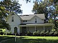
A historic building in the Friars Point Historic District.
-
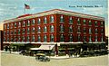
The historic New Alcazar Hotel in Clarksdale.
-
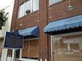
The WROX Building, a famous radio station in Clarksdale.
-
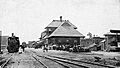
The Yazoo and Mississippi Valley Passenger Depot, now the Delta Blues Museum.


