
Friars Point, Mississippi facts for kids
Quick facts for kids
Friars Point
|
|
|---|---|
 |
|

Location of Friars Point, Mississippi
|
|

Friars Point
Location in the United States
|
|
| Country | United States |
| State | Mississippi |
| County | Coahoma |
| Incorporated | 1852 |
| Area | |
| • Total | 1.12 sq mi (2.91 km2) |
| • Land | 1.10 sq mi (2.85 km2) |
| • Water | 0.02 sq mi (0.06 km2) |
| Elevation | 177 ft (54 m) |
| Population
(2020)
|
|
| • Total | 896 |
| • Density | 814.55/sq mi (314.45/km2) |
| Time zone | UTC-6 (Central (CST)) |
| • Summer (DST) | UTC-5 (CDT) |
| ZIP code |
38631
|
| Area code(s) | 662 |
| FIPS code | 28-26060 |
| GNIS feature ID | 2406526 |
Friars Point is a small town in Coahoma County, Mississippi, United States. In 2020, about 896 people lived there. It is located right on the Mississippi River. Friars Point was once a very busy port town. Today, it is the only place in Coahoma County where people can easily reach the river's shore.
Contents
History of Friars Point
Early Days and Founding
Some historians think that the Spanish explorer Hernando de Soto might have crossed the Mississippi River near Friars Point. This would have happened a very long time ago.
The town was started in 1836. It was first called "Farrar's Point". In 1852, the town officially became a city. Its name was changed to "Friars Point" to honor Robert Friar. He was an early settler, a lawmaker, and a businessman. He used to sell fuel to steamboats passing by.
In 1850, Friars Point became the county seat. This meant it was the main town where the county government was located. It took over this role from a nearby town called Delta.
A Busy Port Town
Friars Point was in a great spot on a bend in the Mississippi River. Because of this, it grew into a very important shipping center for cotton. Before the Civil War, it was the biggest cotton shipping center south of Memphis.
Friars Point During the Civil War
During the Civil War, soldiers from the Union took over parts of the town. They also burned some areas. The Robinson-Slack-Marinelli House, which is now called the Minie Ball House, still stands today. It even has marks from cannon fire from gunboats. This house was used as a headquarters by Union General Napoleon Bonaparte Buford.
In December 1862, General William Tecumseh Sherman and Admiral David Dixon Porter met in Friars Point. They gathered 45 transport ships there before attacking Vicksburg.
A Confederate general, James L. Alcorn, also lived near Friars Point. His grave and his old plantation, Eagles Nest, are just a short distance east of town. After the war, Alcorn became a Republican. He later became the governor of Mississippi.
Changes After the War
After the Civil War, there was a period called Reconstruction. In 1875, there was some conflict in Friars Point. This led to a number of people being killed. It also made it harder for some people to vote. This allowed a different political group to gain power.
Interesting Visitors
The famous outlaw and train robber Jesse James visited Friars Point in the 1880s. He met with the local Methodist minister. He also played poker and had drinks at a saloon. The next morning, he was gone.
In 1924, Charles Lindbergh was flying his plane over Friars Point when he ran out of gas. He had to land his plane at a place he later called "The Haunted House".
Decline of Friars Point
In 1887, a railroad line was built to Friars Point. However, a nearby town called Clarksdale began to grow much larger. Clarksdale started to challenge Friars Point for control of the county government.
In 1892, Coahoma County was split into two areas. One was managed from Friars Point, and the other from Clarksdale. But by 1930, Clarksdale became the only county seat. A historian wrote that by then, "Friars Point had receded into a sleepy river community."
In the 1930s, you could take a ferry from Friars Point to Helena, Arkansas. It cost one dollar for a car and driver, and 25 cents for each passenger.
On April 26, 2011, a tornado hit Friars Point. It was part of a very large storm system. The tornado had winds of about 75 miles per hour.
In 2013, Time magazine wrote about Friars Point. It said that the town, once a busy port, had become much smaller. It had only a few places left, like an elementary school, some churches, a city hall, a post office, a small store, and a bank. The town no longer had a doctor, a drug store, or a sit-down restaurant. Kids had to travel to Clarksdale for junior and senior high school.
Delta Blues Music
Friars Point is an important place in the history of blues music.
The famous blues musician Muddy Waters said he only saw Robert Johnson play once. It was on the front porch of Hirsberg's Drugstore in Friars Point. Johnson was playing very powerfully. Muddy Waters said he "stopped and peeked over, and then I left because he was a dangerous man."
In a song from 1937, Robert Johnson sang, "Just come on back to Friars Point, mama, and barrelhouse all night long." In another song, "Traveling Riverside Blues," he sang about his "Friar's Point rider."
The Mississippi Blues Commission placed a Blues Trail marker in Friars Point. This marker honors musician Robert Nighthawk, who lived in Friars Point at different times. In 1940, Nighthawk recorded a song called "Friars Point Blues." In it, he sang about "going back to Friars Point, down in sweet old Dixie Land."
When the marker was put up, Governor Haley Barbour said that Nighthawk made a huge contribution to the blues. He was happy that Nighthawk's influence on blues music would be recognized.
"Friar's Point" is also the name of a song by blues musician Susan Tedeschi. It is on her 1998 album Just Won't Burn.
Geography
Friars Point is in the northern part of Coahoma County. It is very close to the Mississippi River. However, the river's path has moved north over time, away from the town.
The town is about 9 miles (14 km) west of highways 49 and 61. It is also about 13 miles (21 km) north of Clarksdale, which is the county seat.
The United States Census Bureau says that the town covers a total area of about 1.12 square miles (2.9 km2). About 0.02 square miles (0.06 km2) of this area is water.
Population Information
| Historical population | |||
|---|---|---|---|
| Census | Pop. | %± | |
| 1880 | 676 | — | |
| 1890 | 674 | −0.3% | |
| 1900 | 750 | 11.3% | |
| 1910 | 876 | 16.8% | |
| 1920 | 954 | 8.9% | |
| 1930 | 988 | 3.6% | |
| 1940 | 940 | −4.9% | |
| 1950 | 916 | −2.6% | |
| 1960 | 1,029 | 12.3% | |
| 1970 | 1,177 | 14.4% | |
| 1980 | 1,400 | 18.9% | |
| 1990 | 1,334 | −4.7% | |
| 2000 | 1,480 | 10.9% | |
| 2010 | 1,200 | −18.9% | |
| 2020 | 896 | −25.3% | |
| U.S. Decennial Census 2010 2020 |
|||
The population of Friars Point has changed over the years. In 1880, there were 676 people. The population grew to its highest point in 2000, with 1,480 people. By 2020, the population was 896.
Education
The schools in Friars Point are part of the Coahoma County School District. Students in Friars Point attend Friars Point Elementary School. For junior and senior high school, they go to Coahoma County Junior-Senior High School.
Notable People
- Lewis E. Sawyer: He was a lawyer in Friars Point and later became the mayor. He also served as a congressman for Arkansas.
- Conway Twitty: A famous country music singer. He once held the record for having the most number-one hit songs.
Images for kids
-
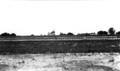
Friars Point from the levee, around 1900
-
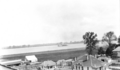
View of the Mississippi River from the courthouse roof, around 1900
-
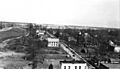
Looking north from the courthouse, around 1900
-
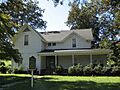
The Minie Ball House, the oldest house in Friars Point
-
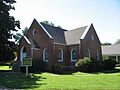
Friars Point United Methodist Church


See also
 In Spanish: Friars Point para niños
