
National Register of Historic Places listings in Colfax County, New Mexico facts for kids

Welcome to Colfax County, New Mexico! This area is full of amazing places that tell stories about the past. Many of these special spots are listed on the National Register of Historic Places. This is like a special list of buildings, sites, and objects across the United States that are important to history. When a place is on this list, it means it's worth protecting and learning about.
In Colfax County, there are 30 places on this important list. Two of them are even more special, called National Historic Landmarks. These landmarks are extra important because they represent a big part of our nation's history. Most of these historic places in Colfax County are also on New Mexico's own list of cultural properties. However, two very famous ones, the Folsom Site and Raton Pass, are only on the national list. Let's explore some of these fascinating historic sites!
Contents
Historic Towns and Districts
Colfax County has several towns and areas that are preserved because of their rich history. These places help us imagine what life was like long ago.
Cimarron Historic District
The Cimarron Historic District is a special part of the town of Cimarron. It's located along State Road 21. This area was added to the National Register in 1973. It includes many old buildings that show what the town looked like in the past. Walking through this district is like taking a step back in time!
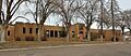
Original Townsite Historic District (Raton)
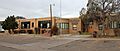
In the city of Raton, there's an area called the Original Townsite Historic District. It includes streets like Clark and Cimarron Avenues. This district was recognized in 2008. It shows the original layout and buildings from when Raton was first settled. It's a great example of how towns grew in the American West.
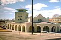
Raton Downtown Historic District
Another important area in Raton is the Raton Downtown Historic District. This busy part of the city, roughly bounded by Rio Grande, Clark, 1st, and 3rd Streets, was added to the National Register in 1977. It's where many historic shops and buildings are located. It shows the heart of Raton's community and business life through the years.
Point of Rocks Historic District
Near Springer, you'll find the Point of Rocks Historic District. This district, added in 1994, is located on Jones Well Road. It's a significant spot along the historic Santa Fe Trail. This trail was a very important trade route in the 19th century.
Important Buildings and Structures
Many individual buildings and structures in Colfax County have been preserved for their historical value. They often show unique architecture or played a key role in the community.
Colfax County Courthouses
Colfax County actually has two historic courthouses on the National Register!
- The Colfax County Courthouse in Raton is located at 3rd and Savage Streets. It was built in 1909 and added to the National Register in 1987. Courthouses are important because they are where local laws and government decisions are made.
- The Colfax County Courthouse in Springer is at 614 Maxwell Avenue. This building was also added in 1987. It served as the county courthouse before the one in Raton. Both buildings tell us about the history of local government in the area.
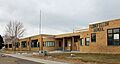
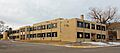
Historic Schools in Raton
Several old school buildings in Raton are on the National Register. These schools taught generations of students and are important parts of the community's history.
- The Columbian School at 700 N. 2nd Street was listed in 1996.
- The Kearny School at 800 S. 3rd Street was also listed in 1996.
- The Longfellow School at 700 E. 4th Street joined the list in 1996.
- The Raton Junior-Senior High School at 500 S. 3rd Street was added in 1996.
These buildings show how education has changed over time and how important schools were to the growth of Raton.
El Raton Theater
The El Raton Theater at 115 N. 2nd Street in Raton is a historic movie theater. It was added to the National Register in 2007. Imagine watching movies in this theater many years ago! It's a reminder of how people entertained themselves in the past.
R.H. Cowan Livery Stable
In Springer, the R.H. Cowan Livery Stable at 220 Maxwell Avenue was listed in 1979. A livery stable was a place where people could rent horses and carriages, or keep their own horses. This building tells us about transportation before cars became common.
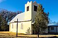
Immanuel Lutheran Church (Springer)
The Immanuel Lutheran Church at 307 Summit Avenue in Springer was added to the National Register in 2015. Churches are often central to a community's history and culture, serving as places of worship and gathering for many years.
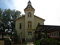
St. John's Methodist Episcopal Church (Raton)
East of Raton, on Johnson Mesa, stands the St. John's Methodist Episcopal Church. This church, listed in 1978, is located about 17 miles from Raton. It's a beautiful example of a historic rural church.
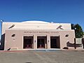
Raton Armory
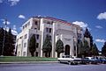
The Raton Armory at 901 S. 3rd Street in Raton was added to the National Register in 1996. An armory is a place where military equipment is stored and where soldiers train. This building shows the history of military presence and community defense in Raton.
Unique Historic Sites
Colfax County also has some very unique historic sites, including ancient archaeological discoveries and grand estates.
Folsom Site (National Historic Landmark)
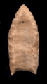
The Folsom Site near Folsom is a very important archaeological site. It's so important that it's a National Historic Landmark, listed in 1966. This site is famous for the discovery of "Folsom points," which are special spear points used by early people in North America over 10,000 years ago! It helped scientists understand how old human history in the Americas truly is.
Raton Pass (National Historic Landmark)
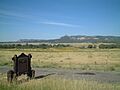
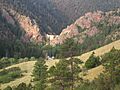
Another National Historic Landmark in Colfax County is Raton Pass, located on the border between New Mexico and Colorado. This pass, listed in 1966, was a crucial route through the mountains for travelers, traders, and settlers for centuries. It was part of the Santa Fe Trail and later used by railroads. Its steep slopes and challenging terrain made it a famous obstacle.
Catskill Charcoal Ovens
About 35 miles west of Raton, you can find the Catskill Charcoal Ovens. These ovens, listed in 1978, were used to make charcoal. Charcoal was important for industries like mining and smelting in the past. These ovens are a cool example of old industrial technology.
Clifton House Site
The Clifton House Site near Raton was added to the National Register in 1995. While its exact location is restricted to protect it, this site was once a stagecoach station along the Santa Fe Trail. It was a vital stop for travelers needing rest, food, and fresh horses on their long journeys.
Dorsey Mansion
The Dorsey Mansion, located about 12 miles northeast of Abbott, is a grand and historic home. It was listed in 1970. This mansion was built by a powerful senator and is known for its unique architecture and history. It's like a castle in the New Mexico landscape!
Eagle Nest Dam
The Eagle Nest Dam, located southeast of Eagle Nest, was added to the National Register in 1979. Dams are important structures that create lakes and help manage water for farming and communities. This dam helped create Eagle Nest Lake, a popular spot today.
El Vado de las Piedras and the Santa Fe Trail-Colfax County Trail Segments
Near Springer, you can find El Vado de las Piedras and parts of the Santa Fe Trail. This area, listed in 1994, is where the trail crossed the Canadian River. "El Vado de las Piedras" means "the ford of the stones," referring to a rocky crossing point. It reminds us of the challenges faced by early travelers.
Dawson Cemetery
The Dawson Cemetery, located about 4 miles northwest of the junction of U.S. Route 64 and Dawson Road, was added to the National Register in 1992. Cemeteries are important historical sites because they tell us about the people who lived in an area and the history of their communities.
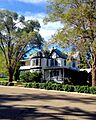
Villa Philmonte Historic District
The Villa Philmonte Historic District is located within the famous Philmont Scout Ranch near Cimarron. This district was listed in 1995. Villa Philmonte is a large, beautiful home that was once the summer residence of Waite Phillips, who later donated the land for the scout ranch. It's a place where history and nature come together.
Images for kids
-
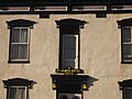
A historic building in the Cimarron Historic District.
-
The site of the historic Clifton House.
-
The Colfax County Courthouse in Raton.
-
The former Colfax County Courthouse in Springer.
-
The historic Columbian School in Raton.
-
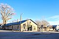
The R.H. Cowan Livery Stable in Springer.
-
A view near Eagle Nest Dam.
-
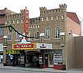
The historic El Raton Theater in Raton.
-
A Folsom point, found at the Folsom Site.
-
The Immanuel Lutheran Church in Springer.
-
The historic Kearny School in Raton.
-
The historic Longfellow School in Raton.
-
A home in the Original Townsite Historic District in Raton.
-
The Raton Armory, now a convention center.
-
A train in the Raton Downtown Historic District.
-
The historic Raton Junior-Senior High School.
-
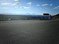
Raton Pass, a historic route.
-
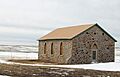
St. John's Methodist Episcopal Church.
-
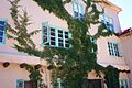
A wall at Villa Philmonte.


_Picture_1987.jpg)


.JPG)

_-_Raton_Convention_Center(present).JPG)


