
National Register of Historic Places listings in Craighead County, Arkansas facts for kids

This article is about the cool historic places in Craighead County, Arkansas, that are listed on the National Register of Historic Places. Think of it like a special list of buildings, sites, and objects that are important to American history, architecture, archaeology, engineering, or culture. When a place is on this list, it means it's recognized as a valuable part of our past and should be protected.
Craighead County is in Arkansas, United States. There are 23 special places in the county that have made it onto this important list. Some of these places are buildings, some are bridges, and one is even a gravesite! You can see where many of these places are located on a map if their exact coordinates are shared.
Contents
What is the National Register of Historic Places?
The National Register of Historic Places is the official list of the nation's historic places worth saving. It's managed by the National Park Service, which is part of the U.S. government. Being on this list helps people understand and appreciate the history around them. It also encourages communities to preserve these important sites for future generations.
When a place is added to the National Register, it means it has a special story to tell. It might be a very old building, a place where an important event happened, or a site that shows how people lived a long time ago.
Historic Places in Craighead County
Craighead County has many interesting places that tell us about its past. Let's explore some of them!
Important Buildings and Homes
Many of the places on the list are historic buildings, including homes, banks, and community centers. These structures often show us how people lived and worked in different eras.
The Bell House: A Glimpse into the Past
The Bell House is located at 303 West Cherry Street in Jonesboro. It was added to the National Register in 1976. This house is a great example of the architecture from its time. It helps us imagine what life was like in Jonesboro many years ago.

Berger House and Berger-Graham House
The Berger House (1120 South Main Street) and the Berger-Graham House (1327 South Main Street) are also in Jonesboro. The Berger House was listed in 1996, and the Berger-Graham House in 1985. These homes are important because they show the architectural styles and living arrangements of families in the past.

Community Center No. 1
The Community Center No. 1 at 1212 South Church Street in Jonesboro was added to the list in 2008. Community centers are often places where people gather, learn, and connect. This building likely played an important role in the social life of the community.

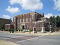
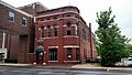
Craighead County Courthouse
The Craighead County Courthouse is a very important building located at 511 Main Street in Jonesboro. It was listed in 1998. Courthouses are central to local government and justice. This building has seen many important decisions and events in the county's history.

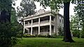
Frierson House
The Frierson House at 1112 South Main Street in Jonesboro was added to the National Register in 1973. Like other historic homes, it helps us understand the architectural styles and daily lives of people from earlier times.

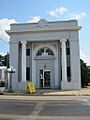
Mercantile Bank Building
The Mercantile Bank Building at 249 South Main Street in Jonesboro was listed in 2005. Banks are important for the economic history of a town. This building shows the kind of architecture used for financial institutions in the past.

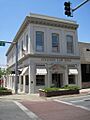
Edward L. Westbrooke Building
The Edward L. Westbrooke Building at 505 Union Street in Jonesboro was added in 2003. This building is another example of the commercial and architectural history of the area.

Historic Figures and Sites
Some places are important because of the people connected to them.
US Senator Hattie Caraway Gravesite
The US Senator Hattie Caraway Gravesite is located in Oaklawn Cemetery in Jonesboro. It was listed in 2007. Hattie Caraway was an amazing person because she was the first woman elected to a full term in the United States Senate. This means she was the first woman to serve a complete six-year term as a senator for a state. Her gravesite is a reminder of her important role in American history and women's rights.

Bridges and Other Structures
Not all historic places are buildings. Some are structures like bridges or even water towers!
Craighead County Road 513C Bridge
The Craighead County Road 513C Bridge is located near Dixie. It was listed in 1995. Bridges are important for transportation and often show interesting engineering techniques from the past.
First National Bank Building (Monette)
The First National Bank Building at 207 West Drew Avenue in Monette was added to the list in 2008. This building is now home to the Buffalo Island Museum. It's a great example of how old buildings can be given new life while still preserving their history.

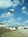
Monette Water Tower
The Monette Water Tower was listed in 2008. It's located at the corner of Highway 139 and Texie Avenue in Monette. Water towers are often landmarks in small towns and are important for providing water to the community.

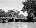
St. Francis River Bridge
The St. Francis River Bridge near Lake City was listed in 1990. This bridge carried Highway 18 over the St. Francis River. Although most of it was taken down in 1998, the vertical lift section (the part that could be raised to let boats pass) still remains. This shows a unique type of bridge engineering.

Historic Districts
Sometimes, a whole area or group of buildings is considered historic. This is called a historic district.
West Washington Avenue Historic District
The West Washington Avenue Historic District in Jonesboro was added to the National Register in 1982. This district includes buildings from 500 to 626 West Washington Avenue. Historic districts are important because they preserve the overall look and feel of a neighborhood from a specific time period.

Images for kids
-
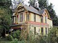
The historic Bell House in Jonesboro.
-
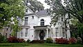
The Berger House in Jonesboro.
-
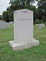
The gravesite of US Senator Hattie Caraway.
-
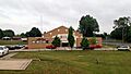
Community Center No. 1 in Jonesboro.
-
The Craighead County Courthouse.
-
The First National Bank Building in Monette, now the Buffalo Island Museum.
-
The Frierson House.
-
The Mercantile Bank Building.
-
The Monette Water Tower.
-
The St. Francis River Bridge near Lake City.
-

Part of the West Washington Avenue Historic District.
-
The Edward L. Westbrooke Building.
