
National Register of Historic Places listings in Crow Wing County, Minnesota facts for kids

Hey there! Did you know that all across the United States, there are special places that are super important to history? These places are listed on something called the National Register of Historic Places. It's like a big list of buildings, parks, and other spots that tell amazing stories about the past.
In Crow Wing County, Minnesota, there are 36 of these cool historic places! They include old libraries, water towers, bridges, and even places where people lived thousands of years ago. Let's explore some of them and learn about their unique histories.
Contents
Cool Historic Places in Crow Wing County
Buildings with Big Stories
Many buildings in Crow Wing County have played a huge role in their communities.
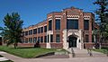
- Brainerd Public Library: This beautiful library was built in 1904. It's a great example of a "Carnegie library," which means it was funded by famous businessman Andrew Carnegie. It has a fancy style called Neoclassical architecture, which looks a bit like ancient Greek or Roman buildings.
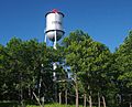
- Brainerd Water Tower: This isn't just any water tower! Built between 1918 and 1921, it was the very first city water tower in the entire country made completely out of concrete. It's a unique landmark in Brainerd.
- A.L. Cole Memorial Building (Pequot Lakes): This building was finished in 1937. It's special because it was built with money from the "New Deal," a program that helped create jobs during the Great Depression. It used to be a movie theater and now it's a senior center and museum, still serving the community!
- Crow Wing County Courthouse and Jail (Brainerd): This important government center includes a jail from 1916 (now a museum) and a courthouse built in 1919–1920. It's a grand building that shows off the "City Beautiful movement," which aimed to make cities more beautiful and orderly.
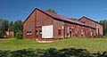
- Deerwood Auditorium: Another awesome building funded by the New Deal, this auditorium was built between 1935 and 1937 using local stone. It was the biggest project of its kind in Minnesota at the time and has been a central spot for community events for many years.
- Franklin Junior High School (Brainerd): This school, built in 1932 with an addition in 1954, shows how school designs changed over time. Today, it's known as the Franklin Arts Center.
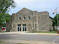
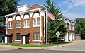
- Ironton City Hall: Built in 1917, this building was the heart of Ironton. It housed city offices, the fire department, a library, a jail, and an auditorium for community gatherings.
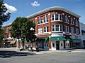
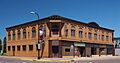
- Parker Building (Brainerd): This well-preserved commercial building from 1909 is a great example of early 20th-century shops. It was home to many local businesses, including one of Brainerd's first banks.
- Spina Hotel (Ironton): This grand hotel was built in 1913. It had many shops and fancy architecture, showing how much people thought the area would grow during the mining boom.
Water Towers of the Cuyuna Range
The Cuyuna Range was a big iron mining area. When mining brought in a lot of money, towns built important things like water towers. Several of these old water towers are still around and are listed as historic places.
- Elevated Metal Water Tank, Crosby: Built between 1912 and 1918.
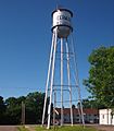
- Elevated Metal Water Tank, Cuyuna: This one was built in 1912.
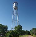
- Elevated Metal Water Tank, Deerwood: This tower dates back to 1914.
- Elevated Metal Water Tank, Ironton: Built in 1913.
- Elevated Metal Water Tank, Trommald: This water tower was completed in 1918.
These towers are some of the few remaining examples of the big public projects that were funded by the mining industry's success.
Parks, Trails, and Outdoor Wonders
Crow Wing County is also home to important outdoor historic sites.
- Crow Wing State Park: This park is a very old and important place. It was a key meeting point for the Dakota people and Ojibwe people and later for fur traders and loggers. The old town of Old Crow Wing was here, and its abandonment in the 1880s helped preserve the history of Native Americans, the fur trade, and logging.
- Garrison Concourse: Built between 1936 and 1939 by the Civilian Conservation Corps (a New Deal program that put people to work), this large roadside area was one of the first big projects to improve highways. It mixes formal design with a natural, "rustic" style.
- Kenney Lake Overlook: This roadside overlook from 1939 was another project by the Civilian Conservation Corps. It was part of early efforts by the Minnesota Highway Department to make scenic improvements along roads.
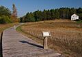
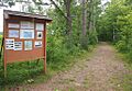
- Red River Trail: Crow Wing Section: This is a well-preserved part of an old trail used from 1844 to 1871. It stretches about 1.5 miles through Crow Wing State Park, crossing the Mississippi River and going through the old town of Old Crow Wing. Today, it's a hiking trail!
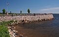
- St. Alban's Bay Culvert at Mille Lacs Lake: This bridge, built between 1938 and 1939, is a rare example of a bridge designed for recreational areas. It was part of a large New Deal project along Mille Lacs Lake and has a rustic design that fits with nature.
Homes and Resorts with History
Some historic places are old homes or popular vacation spots.
- H. H. Broach House (Pequot Lakes): Also known as Shawano House, this summer home from the mid-1920s is famous for its impressive "rustic architecture" made of logs and stone.
- Wilford H. Fawcett House (Breezy Point): This lodge-like summer home was built in the mid-1920s. It's known for its beautiful rustic design and its connection to Wilford Fawcett, who started Fawcett Publications (a big magazine company). Today, it's a rental property at a lake resort.
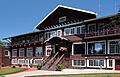
- Grand View Lodge (Nisswa): This lake resort has two special buildings. The main lodge from the mid-1920s has some of the most detailed rustic log architecture in the area. Another lodge from 1918 was one of the very first resorts in the region.
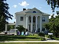
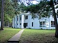
- Werner Hemstead House (Brainerd): Built around 1900, this house stands out for its unique Neoclassical architecture. It was also home to Werner Hempstead, an important politician and business leader in Brainerd.
- Minnewawa Lodge (Nisswa): This is a rare example of the area's earliest resorts, with three wooden buildings built between the 1890s and 1920s. It shows how resorts looked before the rustic style became popular.
Industrial and Archaeological Sites
These sites tell us about how people worked and lived long ago.
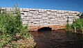
- Bridge No. 5265-Garrison: This bridge from 1938 is a great example of bridges built during the New Deal. It has a cool design with an iron-plate arch and beautiful stone work.
- Fort Flatmouth Mounds (Crosslake vicinity): These are a group of oval-shaped mounds. People once thought they were a fort, but now they're important for helping us learn about the long history of Native American people living in this area.
- Gordon-Schaust Site (Crosslake vicinity): This site has two separate but almost parallel groups of long, narrow mounds. Their exact age isn't known, but they are very well preserved.
- Ironton Sintering Plant Complex (Crosby): This facility from 1924 was the second major "beneficiation" plant ever built in the United States. It helped process low-grade iron ore, which was a big step forward for the iron and steel industry.
- Milford Mine Historic District (Wolford vicinity): These are the remains of the Milford Mine, which operated from 1912 to 1932. It's famous for being the site of Minnesota's worst mining disaster, where 41 miners died in 1924. Today, it's a memorial park.
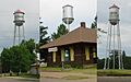
- Minnesota and International Railroad Freight House and Shelter Shed (Nisswa vicinity): Built around 1918, this open-air railway shelter is the only one left in North Central Minnesota. It reminds us how important railroads were for bringing people and goods to the area when summer resorts were just starting. It's also known as the Lake Hubert Depot.
- Northern Pacific Railroad Shops Historic District (Brainerd): This is one of the few remaining large railroad maintenance complexes in Minnesota. It has 12 buildings built between 1882 and 1938 and shows how important the Northern Pacific Railway was as Brainerd's biggest employer for many years.
- Sebre Lake Site (Fort Ripley vicinity): This is one of the most important archaeological sites in the Nokasippi River Valley. It has evidence of people living and burying their dead over 4,000 years, from the Archaic to the Late Woodland period.
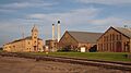
- Soo Line Depot (Crosby): This railway station from 1910 was super important for bringing people and goods into central Crow Wing County and for shipping out iron ore during a big economic boom. Now, it's a museum.
- St. Columba Mission Site (Nisswa vicinity): This was the site of an Episcopal mission to the Ojibwe people from 1852 to 1862. It's an important archaeological site that helps us understand the lives of early missionaries and the Native Americans who converted.
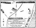
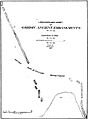
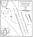
- Upper Hay Lake Archeological District (Jenkins vicinity): This area has about 75 long mounds, including one of the longest in the state (725 feet!). It also has the sites of an old village and a portage, showing a lot of activity during the Blackduck phase of the Late Woodland period.
Images for kids
-
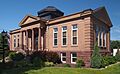
The Brainerd Public Library, a beautiful Carnegie library.
-
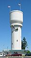
The Brainerd Water Tower, the first concrete municipal water tower in the U.S.
-
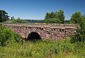
Bridge No. 5265-Garrison, a New Deal-era bridge with fine stone masonry.
-
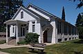
The A.L. Cole Memorial Building in Pequot Lakes.
-
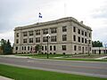
The Crow Wing County Courthouse in Brainerd.
-
A view of Crow Wing State Park, a historic site at a key travel junction.
-
The Deerwood Auditorium, built with local stone during the New Deal.
-
Elevated Metal Water Tanks in the Cuyuna Range.
-
The 1912 water tower in Cuyuna.
-
The 1914 water tower in Deerwood.
-
The 1918 water tower in Trommald.
-
The Fort Flatmouth Mounds, once mistaken for a fortification.
-
Franklin Junior High School in Brainerd, now the Franklin Arts Center.
-
The Garrison Concourse, a large highway wayside built by the Civilian Conservation Corps.
-
The linear mounds at the Gordon-Schaust Site.
-
Grand View Lodge in Nisswa, known for its rustic log architecture.
-
The Werner Hemstead House in Brainerd.
-
Ironton City Hall, a multipurpose municipal building.
-
The Ironton Sintering Plant Complex.
-

The Kenney Lake Overlook, a scenic wayside.
-
Milford Mine Memorial Park, site of a mining disaster.
-
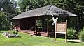
The Minnesota and International Railroad Freight House and Shelter Shed, also known as the Lake Hubert Depot.
-
Minnewawa Lodge, a rare example of an early resort.
-
The Northern Pacific Railroad Shops Historic District in Brainerd.
-
The Parker Building in Brainerd, an intact early 20th-century commercial block.
-
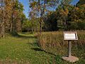
A well-preserved fragment of the Red River Trail.
-
St. Alban's Bay Culvert at Mille Lacs Lake.
-
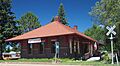
The Soo Line Depot in Crosby, now a museum.
-
The Spina Hotel in Ironton.
-
A map related to the Upper Hay Lake Archeological District.


