Old Crow Wing, Minnesota facts for kids

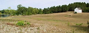
Old Crow Wing is a ghost town in Crow Wing County, Minnesota, United States. A ghost town is a place where most people have left, and it's often empty or has very few residents. Old Crow Wing is located where the Mississippi River and the Crow Wing River meet. This spot was important for the Ojibwe people for a long time. For over a hundred years, it was also the furthest north European-American settlement on the Mississippi River.
In the 1850s and 1860s, Crow Wing was a very important town in Minnesota. It was the county seat, which means it was the main town for the county's government. At its busiest, about 600 to 700 people lived there. About half of these residents were Ojibwe. Today, the old town site, including one house that has been fixed up, is part of Crow Wing State Park.
Contents
A Meeting Place for People
This area was home to indigenous peoples for thousands of years. The spot where the Crow Wing and Mississippi rivers join was a natural meeting place. It was used by the Dakota people and later by the Ojibwe people of Minnesota.
Early European Traders
Old Crow Wing's location was also perfect for European traders. The first traders arrived shortly after a big war called the French and Indian War ended in 1763. One of the first important traders was James McGill, who spent time there in 1771–1772. Many other traders followed him.
The first European-American to settle in Crow Wing was Allan Morrison. He opened a trading post there in 1823. A trading post was like a store where people traded furs and other goods.
The Red River Trails
Around this time, a busy trade route grew between Saint Paul, Minnesota, and the Red River Colony in Canada. Many of the fur trappers and traders were Métis. Métis people were often the children of Ojibwe mothers and French, Scottish, or English fathers. They developed their own unique culture.
The main trade routes, called the Red River Trails, went through land belonging to the Dakota people. The Dakota were traditional enemies of the Ojibwe. Because of this, there were often conflicts. In 1844, a Métis attack on the Dakota closed the main route.
A group of Red River ox carts, which were like big wooden wagons pulled by oxen, had to find a new way home. They traveled to Crow Wing, crossed the Mississippi River, and created a new path. This new path went through friendly Ojibwe lands and became known as the Woods Trail. Even though it was harder to travel, it was much safer. More and more traders started using this route.
Crow Wing as a Supply Stop
The village of Crow Wing became the main place to get supplies on the Woods Trail. Allan Morrison started a ferry service to cross the Mississippi River at the north end of town. A ferry is a boat that carries people and goods across a river. In the 1840s, other traders also opened shops. Crow Wing became a diverse community with many mixed-race families, as well as Ojibwe, French Canadian, and American families.
Many important people lived or worked in Crow Wing. Allan Morrison and his brother William Morrison, along with traders William Alexander Aitken and Henry Mower Rice, became well-known in the area. Some Minnesota counties, like Morrison, Aitkin, and Rice, are named after them. Clement Hudon Beaulieu, who was Métis, also became a very successful trader.
William Whipple Warren, who was also of Ojibwe descent, worked as an interpreter. He spoke both English and Ojibwe. He interviewed Ojibwe elders and wrote an important book called History of the Ojibway People in 1853.
Several important Ojibwe leaders lived in Crow Wing, including Curly Head and Hole in the Day. These leaders worked with Henry Rice to allow logging on their land. Logging, which is cutting down trees for wood, became a big business in Crow Wing.
Growth and Decline of Crow Wing
In 1848, the U.S. Army built Fort Ripley nearby. In 1849, Clement Beaulieu, a successful trader, built a beautiful house in the popular Greek Revival style. Churches also came to Crow Wing. A Catholic mission was started in 1852, and an Episcopal mission was built in 1856. A Lutheran church followed soon after.
The End of an Era
Two main events caused Crow Wing's importance to end quickly. In 1868, the United States government moved the Ojibwe people, including Clement and Elizabeth Beaulieu, to the White Earth Indian Reservation in northwestern Minnesota.
Then, in 1871, a powerful railroad owner named James J. Hill decided to build his Northern Pacific Railway across the Mississippi River at Brainerd. Brainerd was ten miles north of Crow Wing, and this meant the railroad would completely bypass Crow Wing. A year later, Brainerd became the new county seat. Businesses and people quickly moved there from Crow Wing.
By 1880, most of Crow Wing's residents had left. Clement Beaulieu's nephews moved his old house to Morrison County. It was lived in until the 1980s. In 1988, the house was moved back to its original spot, which is now part of Crow Wing State Park.
 | Jackie Robinson |
 | Jack Johnson |
 | Althea Gibson |
 | Arthur Ashe |
 | Muhammad Ali |

