Red River Trails facts for kids
The Red River Trails were old travel paths used by ox carts. These trails connected the Red River Colony (which is now Winnipeg, Manitoba, Canada) with the Mississippi River in the United States. They were super important for trade and travel between the 1820s and early 1870s.
Imagine a time before trains and highways! These trails were the main way for people in the Red River Colony to get supplies and sell their goods, like furs. The colony was quite isolated, so these trails were their link to the outside world.
The trails were mostly used by the Métis people, who are a unique group with both Indigenous and European (often French) heritage. They used special carts called Red River ox carts. These carts helped them trade with the United States, especially with a town called Saint Paul in Minnesota. This trade was so big it even helped new towns grow in Minnesota and North Dakota. It also helped settle western Canada.
For a while, this trade across the border was so strong that it made Canada worry about losing control of its western lands. But then, new train lines were built both in Canada and the U.S. These trains were much faster and could carry more goods, so the old ox cart trails became less important. Today, modern transportation like trucks and trains still use similar routes, showing how important these paths were long ago!
Contents
How the Trails Started
In 1812, a man named Thomas Douglas, 5th Earl of Selkirk, started a new settlement. It was located where the Assiniboine River meets the Red River, in what is now Winnipeg. This colony was the only farming settlement between Upper Canada and the Pacific Ocean.
The settlers and their Métis neighbors were very isolated. They were surrounded by a rugged area called the Canadian Shield and hundreds of miles of wilderness. To get supplies or sell goods, they had only two very difficult water routes:
- One route went all the way to Hudson Bay and then across the ocean to Great Britain. This was a very long journey, about 780 miles (1250 km) just to Hudson Bay!
- The other route went through many lakes and rivers to Montreal. This was also a long trip, about 500 miles (800 km) to Lake Superior, and then even further to Montreal.
Neither of these water routes was good for carrying heavy items. They involved dangerous lakes, shallow rivers, and many "portages." A portage is where people had to carry their boats and all their goods over land between waterways.
But there was another way! The land south of the Red River Colony was flat and open. This area, now in Minnesota, had a natural path leading to the Mississippi River. The Red River flows north, but the Minnesota River (which flows into the Mississippi) starts very close by. There was only about a mile (1.6 km) of land separating their sources. This flat land made it easy to travel south. So, the settlers looked to the new United States for supplies and a way to sell their furs, even if it was technically against the rules of the Hudson's Bay Company.
Developing the Routes
Before the ox carts, Native Americans and fur traders used paths in the area. These paths connected fur trading posts along the Mississippi River, Minnesota River, and Red River. The Columbia Fur Company was one of the first to use ox carts to move furs and goods. They also helped develop these trails. By the early 1830s, the trails were well-known.
Early trips helped map out the main route. For example, in 1815, cattle were brought to the Red River Colony from Missouri. In 1819, after a locust plague, an expedition went to buy seeds. These early journeys showed that travel between the Red River and the Mississippi was possible.
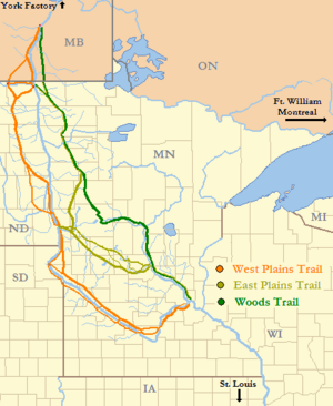
West Plains Trail
The West Plains Trail was originally an Indigenous path. It followed the west bank of the Red River south from the Red River Settlement to Pembina. Pembina was a fur-trading post right on the border.
From Pembina, most carts went west and then south, staying on the higher ground. This helped them avoid crossing many small rivers and the swampy, flood-prone areas near the Red River.
The trail then turned southeast, meeting the Red River again at places like Georgetown and Fort Abercrombie. From there, it followed the river south to Lake Traverse. Some carts went through the Traverse Gap, a low area between lakes, and then along the Minnesota River. Others took a shortcut across the open prairie.
The trail continued along both sides of the Minnesota River valley. It passed fur posts and Native American agencies. Finally, it reached Traverse des Sioux, where goods were often moved to flatboats. Later, most carts crossed to the east bank and went to Fort Snelling or Mendota, where the Minnesota River joins the Mississippi. From there, furs were shipped down the Mississippi.
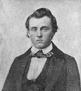
Trade became more regular around 1835. The Hudson's Bay Company tried to stop this trade, but it just made traders like Norman Kittson move their operations across the U.S. border. Kittson's business grew huge, with hundreds of ox carts traveling from Pembina. Even though some fur trade shifted to other routes later, the forts and settlements along the West Plains Trail kept it busy. The U.S. Army even improved parts of it in the 1850s.
Woods Trail
The West Plains Trail was long and went through lands of the Dakota people. The Dakota were enemies of the Ojibwa, and many Métis carters had Ojibwa family. This sometimes led to fights. For example, in 1844, a conflict meant traders couldn't safely return on the usual route.
So, they found a new path. They went northwest up the Mississippi River to Crow Wing, then west to Otter Tail Lake, and finally northwest to the Red River. By 1846, this new route was well-established. It was called the Woods Trail or Crow Wing Trail.
As its name suggests, this trail went through some wooded areas. From Fort Garry, carts followed the eastern edge of the Red River plains, crossing the border into Minnesota. It followed a gravel ridge, which was an old beach of a prehistoric lake. It crossed the Red Lake River and then angled southeast to White Earth.
At Otter Tail Lake, the trail turned east into a forest. It crossed the Mississippi River at Old Crow Wing. Then it went south along the east bank of the Mississippi to Sauk Rapids and East Saint Cloud.
The last part of the trail went to Saint Paul, which had become the main trading center. Carters would camp on the hills above the town. The Woods Trail was not always the easiest path, but it was safer because it stayed within Ojibwa lands. The U.S. Army also improved this trail in the late 1850s.
East Plains Trail
The East Plains Trail (also called the Middle Plains Trail) also became popular in the 1840s. It was shorter than the West Plains Trail. When trader Henry Hastings Sibley retired in 1854, his partner Norman Kittson moved their large cart trains to this East Plains route.
The East Plains Trail followed parts of the West Plains Trail from Pembina to Breckenridge. Then it turned east, crossing valleys to Saint Cloud and Sauk Rapids on the Mississippi River. A branch was later added to connect it with the Woods Trail.
At Saint Cloud, some furs were moved to riverboats on the Mississippi. Other cart trains crossed the Mississippi and continued to Saint Paul, sharing a route with the Woods Trail.
This trail went through a landscape of lakes and hills. As more people settled in Minnesota, the routes were improved. Stagecoach services started, towns grew, and permanent settlements began.
Trade and Business
At first, the trails were used to get seeds and supplies for the Selkirk colony. Soon, they became important trade routes for fur traders. By the 1830s, American fur traders were using them a lot. They bought furs from Métis traders in British North America who were trying to avoid the Hudson's Bay Company's rules.
The Red River settlement was far away from everything. Getting supplies from Britain by way of Hudson Bay took a whole year! But from Saint Paul, settlers could get what they needed in just one summer. Because it was so much easier and cheaper to ship goods over the trails, the Hudson's Bay Company couldn't stop the trade. By 1850, their monopoly (exclusive control) was broken. The company itself even started using the Red River Trails for its own heavy trade by 1857.
The main thing exported from the Red River settlements was fur. But as the colony grew, they also sent extra farm products south. Imports were more varied. They included seeds, spices, tools, and even liquor. As the buffalo herds declined, the trade shifted from furs to goods needed by settlers. The trails became like a "common carrier" for all kinds of items. This included lamps, fine cloth, books, champagne, stoves, farm machinery, and even a piano and a printing press for the first newspaper in the area!
Life on the Trail
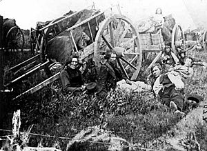
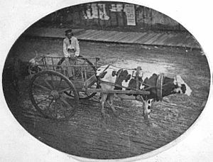
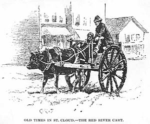
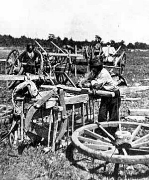
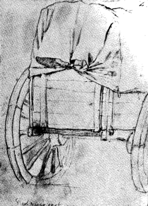
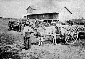
The people who drove the carts were usually Métis. Their carts were called Red River ox carts. These carts were special because they were made entirely from wood and animal hide, with no iron parts at all! This meant they could be easily repaired with local materials if something broke.
The carts had two big wooden wheels, about five or six feet tall. They were pulled by oxen, which were preferred over horses because they were stronger and could handle swampy areas better.
The axles of the carts were not greased. If they were, dust would stick to the grease and act like sandpaper, stopping the cart. Because they weren't greased, the carts made a terrible, loud squealing noise. People called it "the North West fiddle" or said it sounded worse than a "den of wild beasts." You could hear the noise for miles!
A cart could carry about 800–1,000 pounds (360–450 kg) of goods. Going south, they carried furs. Coming back north, they brought supplies and manufactured goods that weren't available in Fort Garry. The goods were covered with hide or canvas to protect them.
Carts traveled in groups called "brigades," usually ten carts with three drivers and an overseer. These brigades could join together to form long trains, sometimes up to two miles (three km) long! In the 1840s, hundreds of carts used the trails each year. By the late 1860s, thousands were using them. These cart trains moved slowly, about two miles (three km) an hour, covering about twenty miles (thirty km) a day.
When crossing streams that were too deep, the carters would unload the carts, take off the wheels, and lash them together under the cart. Then they would cover the whole thing with hide to make a makeshift boat. They would float the cart across, then reload it. They often tried to cross streams at the end of the day so everything could dry overnight.
Camping by streams offered wood, water, and some safety. But the open prairie could be dangerous. There were times of conflict with Native American groups, like the Dakota War of 1862, which stopped trade for a while. Prairie fires were a risk in dry weather. Wet weather turned trails into muddy messes. Blizzards could leave traders stranded and hungry. Insects were also a big problem, bothering both people and animals.
But there were good things too. Game (animals to hunt) was plentiful, so traders usually had fresh meat. Some people thought the vast prairies looked like a colorful ocean of grass. Summer storms could be amazing, even if they were dangerous. After weeks of treeless plains, the rivers, lakes, and woods of central Minnesota were a welcome sight.
After about six weeks, the cart brigades reached Saint Paul. The carters would camp on a bluff above the town. Locals sometimes found the carters a bit wild-looking, with their mix of "civilized garments and barbaric adornments." One trader from the north called Saint Paul "a wretched little village" where people spent their time drinking or cheating each other. But the trade was important, and the carters' camp was separate from the town, which helped keep things peaceful. After about three weeks of trading, the carters would head back north, loaded with goods, returning to what they considered a more civilized world. The people in Saint Paul, on the other hand, thought the carters were going back to a wild, frozen wilderness!
The End of the Trails
Over time, other ways of transport started to appear. First, flatboats and then steamboats began to travel up the Minnesota River. These boats met the cart brigades, taking some of the load. In 1851, steamboat service started on the Mississippi River.
After the American Civil War, the age of steam really took over. In 1863, Native American land rights in the Red River Valley were settled on the U.S. side. This allowed steamboat service to restart on the Red River. More importantly, railways were built west from Saint Paul and Duluth.
A branch of the St. Paul and Pacific Railroad reached St. Cloud in 1866. It reached Willmar in 1869 and Benson in 1870. Each new railway town became the end point for many cart trains. In 1871, the railway reached the Red River at Breckenridge. From there, steamboats carried goods the rest of the way to Fort Garry.
The long trains of ox carts were replaced by railway trains powered by steam. The old trails slowly disappeared, returning to nature.
Today, only a few signs of the trails remain. Some local roads follow their paths. You can sometimes see slight dips in the land where thousands of carts once passed. Even after more than a century, some soils remain compacted. These subtle signs are sometimes marked at parks or roadside signs. Some trail locations in Minnesota are even recognized on the U.S. National Register of Historic Places.
Why the Trails Were Important
The Red River Trails are not as famous as some other old trails in North America. They weren't the site of big battles, and while sometimes dangerous, other trails had more risks. Maybe they are less known because they didn't lead to new land being added to either the U.S. or Canada.
However, these trails were very important for the development of central North America.
- They helped the Selkirk Settlement survive in its early years.
- They gave settlers and Métis people a way to move and trade that didn't depend on the Hudson's Bay Company.
- As more people used the trails, old fur trading posts grew into towns, and new communities appeared along the cart routes.
- The trails helped speed up the settlement of Minnesota and North Dakota, and also the Canadian northwest.
The trails also had big political effects during a time when Britain (who controlled Canada) and the U.S. were a bit tense with each other. Both countries worried about the other's influence across the border. The trails, born from trade needs and geography, helped create these international connections and tensions.
The U.S. sent military groups along the trails to show its power. They wanted to stop Britain from having fur posts on land the U.S. claimed. The U.S. also worried about Lord Selkirk's colony and Britain's claims to the Red River Valley. They wanted to stop Britain from getting access to the Mississippi River, which Britain had tried to do even after the American Revolutionary War. The U.S. showing its power helped reverse Britain's control of the fur trade in the upper Mississippi valley.
| "I have had occasion to observe the great facilities which nature offers, for a commercial intercourse between the country which I propose to establish, & the American settlements in the Missouri & Illinois Territories; from whence our people might draw their supplies of many articles, by way of the Mississipi & River St. Peters, with greater facility than from Canada or from Europe. This traffic, tho' it might be of small account at first, would increase with the progress of our Settlements, creating a growing demand for many articles of American produce." |
| —A letter from Thomas Douglas, Earl of Selkirk, to U.S. Secretary of State John Quincy Adams, December 22, 1817. He saw how easy it would be to trade with the U.S. |
Later, the Red River Settlement and the Canadian northwest depended on these trade routes to U.S. markets. This made Britain and Canada worry about losing control of their territory. Some people in Minnesota even wanted the U.S. to take over northwestern Canada.
This pressure made Canada take over the Hudson's Bay Company's territory. It also helped lead to Canadian Confederation (when Canada became a country) and the creation of Manitoba. It also pushed Canada to build the Canadian Pacific Railway entirely within Canada. Only after this railway was finished in 1885 did Manitoba and the northwest finally have a reliable way to connect with eastern Canada, without going through the U.S.
Today, the border between Canada and the U.S. is peaceful. There's a stronger sense of Canadian identity, and fears of the U.S. taking over have almost disappeared. Canada and the U.S. now have a formal trading partnership, the North American Free Trade Agreement. This has led to even more trade between the two nations. The trade that flows through the valleys of the Red and Mississippi rivers today is much bigger than Lord Selkirk could have imagined almost 200 years ago. The trade corridor where the Red River Trails once ran is still used for its historic purpose.
See also
 In Spanish: Rutas de Río Rojo para niños
 | Anna J. Cooper |
 | Mary McLeod Bethune |
 | Lillie Mae Bradford |


