Traverse Gap facts for kids

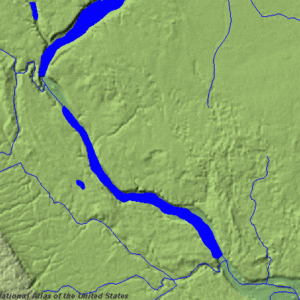
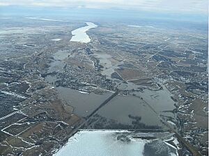
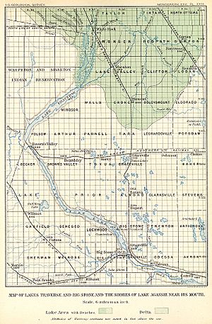
The Traverse Gap is an ancient river channel. It is now home to Lake Traverse, Big Stone Lake, and the valley connecting them at Browns Valley, Minnesota. This special place sits right on the border between the Minnesota and South Dakota. What makes the Traverse Gap truly unique is that a continental divide crosses it. This means that sometimes, during big floods, water can flow from one drainage basin (an area where water collects and flows to a single outlet) into another! Long ago, before 1818, this gap even marked the border between British lands to the north and U.S. (or French) lands to the south.
Contents
How the Traverse Gap Was Formed: A Look Back in Time
The Traverse Gap was carved out at the very end of the last ice age. Imagine a giant sheet of ice, called the Laurentide Ice Sheet, slowly melting and shrinking. As it melted, a huge lake formed from its water, known as Glacial Lake Agassiz.
The Birth of a Giant River
The ice sheet blocked the water from flowing north. To the south, a large pile of rocks and dirt, called the Big Stone Moraine, acted like a dam. Lake Agassiz kept filling up until, about 11,700 years ago, it finally spilled over the moraine. This created a massive waterfall and a huge river called Glacial River Warren.
This powerful river carved the Traverse Gap. It also dug out the valleys for the Minnesota River and the Upper Mississippi River that we see today. River Warren drained Lake Agassiz two more times over the next 2,300 years. This happened when the ice sheet moved back enough to open other paths for Lake Agassiz's water.
The River Disappears
Around 9,400 years ago, Lake Agassiz found a permanent way to drain north. With its main water source gone, River Warren stopped flowing. The deep gorge it had carved then became what we now call the Traverse Gap.
Water's Journey: A Unique Divide

Even though the Traverse Gap is low and flat, it marks the southernmost point of the Northern Divide. This divide separates the waters that flow to the Arctic Ocean from those that flow to the Atlantic Ocean.
Two Paths to the Ocean
- To the North: Lake Traverse is the start of the Bois de Sioux River. This river flows into the Red River of the North, which then goes to Lake Winnipeg and the Nelson River. Finally, its waters reach Hudson Bay in the Arctic Ocean.
- To the South: Big Stone Lake is the beginning of the Minnesota River. This river flows into the Mississippi River, which then empties into the Gulf of Mexico and the Atlantic Ocean.
Big Stone Lake gets its water from the Little Minnesota River. This river starts in South Dakota and flows through the old channel to Big Stone Lake. The Little Minnesota River, which is part of the Mississippi River system, comes very close to Lake Traverse, which is part of the Hudson Bay system. They are less than one mile apart!
When Waters Cross the Divide
The valley floor at Browns Valley is very flat. This means that during heavy rains or floods, water from one basin can actually flow across the continental divide into the other basin!
The highest point on the valley floor is about 987 feet (300.8 meters) above sea level. There's a structure called the Browns Valley Dike at the south end of Lake Traverse. It was built to help stop water from flooding south across the divide. However, the actual divide is a bit lower than the dike. So, if Lake Traverse floods high enough, its water can still flow over the dike and into the Minnesota River system.
Also, the Little Minnesota River, which is usually higher up, has flooded so much that its water has flowed across the divide into Lake Traverse. Even before people built dikes and controls, this "interbasin flooding" happened naturally. This means that water that would normally go to the Gulf of Mexico can sometimes end up in the Arctic Ocean, and in the past, water from Lake Traverse could flow the other way to Big Stone Lake in the Atlantic basin.
The Gap's Size and Location
The ancient channel at Browns Valley is about one mile (1.6 km) wide. It is also about 130 feet (40 meters) deeper than the land around it. The distance between Lake Traverse and Big Stone Lake is about five miles (8 km). The old river channel actually includes these two lakes themselves.
The continental divide crosses the northern part of the gap. The border between Minnesota and South Dakota runs right through the middle of the old channel. On the South Dakota side, you'll find Roberts County, South Dakota. To the east, in Minnesota, is Traverse County, Minnesota and the town of Browns Valley, which is near the continental divide. The southeastern part of the gap is in Big Stone County, Minnesota.
People and the Traverse Gap

People have lived in this area for thousands of years. In 1933, a very old human skeleton was found here, known as "Browns Valley Man." It was found with tools from ancient cultures (Clovis and Folsom types) and is about 9,000 years old.
A Path for Travelers
Native Americans used the Traverse Gap for a very long time. They even placed two buffalo skulls at the divide where travelers would stop to smoke a pipe. Early explorers also understood how important this place was. Major Stephen Harriman Long led an expedition here and wrote about how the two lakes could connect during floods. He noted that it was amazing to see the waters of two huge river systems, one flowing to Hudson Bay (Arctic) and the other to the Gulf of Mexico (Atlantic), starting so close together and even connecting!
Later, fur traders used the native trails. They had trading posts at Lake Traverse and Big Stone Lake. Then, Red River ox carts used these paths as part of the earliest Red River Trails.
Modern Times in the Valley
In the late 1800s, the land was surveyed and sold. Today, the rural parts of the valley floor have pastures, farms, and marshy areas along the Little Minnesota River. The valley was named "Browns Valley" after one of the first settlers, and this name was also given to the town nearby. Minnesota State Highway 28 crosses the valley floor, and it becomes South Dakota Highway 10 at the south end of Lake Traverse.
A Special Natural Landmark
The Traverse Gap has been named a National Natural Landmark. It is officially called the Ancient River Warren Channel. This special honor was given in April 1966 by the United States Secretary of the Interior. It means the Traverse Gap is a truly outstanding example of a geological feature in the United States' natural history. The award describes it as "a channel cut by the Ancient River Warren during the Ice Age, containing the Hudson Bay-Gulf of Mexico divide, with a lake on each side as evidence of the irregularities in Ice Age sedimentation."
 | Misty Copeland |
 | Raven Wilkinson |
 | Debra Austin |
 | Aesha Ash |

