
Fort Ripley (Minnesota fort) facts for kids
Quick facts for kids Fort Ripley |
|
|---|---|
| Camp Ripley, Minnesota in the United States | |

Fort Ripley
Location in the U.S. state of Minnesota
|
|
| Coordinates | 46°10′32″N 94°22′23″W / 46.17556°N 94.37306°W |
| Type | Fort |
| Area | 91 square miles (240 km2) |
| Site information | |
| Owner | United States Army |
| Condition | Archaeological site, one standing building |
| Site history | |
| Built | 1848–49 |
| In use | 1849–1877 |
| Fate | Decommissioned |
| Garrison information | |
| Past commanders |
John Blair Smith Todd |
| Garrison | 6th Infantry Regiment, Company A |

Fort Ripley was an important United States Army outpost in central Minnesota. It was active from 1848 to 1877. The fort was located on the upper Mississippi River, close to areas where the Ho-Chunk and Ojibwe people lived. Its presence helped encourage new settlers to move into the region.
The fort was first called Fort Marcy. Then, it was briefly known as Fort Gaines. In 1850, it was renamed Fort Ripley to honor Brigadier General Eleazer Wheelock Ripley. He was a brave soldier from the War of 1812. Fort Ripley was the second main military fort built in what would become Minnesota. The first was Fort Snelling, built in 1819.
In 1971, Fort Ripley was added to the National Register of Historic Places. This means it's a very important historical site. It was recognized for its role as Minnesota's second major military post. It also helped keep peace and allowed pioneers to settle in Central Minnesota.
Today, Camp Ripley is a training center for the Minnesota National Guard. It was created in 1929 and includes the old Fort Ripley site. The camp was named in honor of the historic fort. The nearby city of Fort Ripley, Minnesota also got its name from the old outpost.
Contents
What Fort Ripley Looked Like
Fort Ripley was a typical army post for its time in the mid-1800s. It was built in a remote area. The buildings were made of timber (wood). They faced a central open space called a quadrangle.
The fort had a partial stockade, which is a fence made of strong posts. The side of the fort facing the river was open. It only had two of its three blockhouses there. A blockhouse is a small, strong fort. The fort was on a river that boats could use. This made it an important route for trade. It was far from big American cities. Native American groups lived nearby.
History of Fort Ripley
Fort Ripley was built because the Ho-Chunk people had been moved. They came from northeastern Iowa to a new reservation near Long Prairie, Minnesota. A military post was needed nearby to watch over the reservation. It also helped manage payments (called annuities) to the Ho-Chunk. The government also hoped the Ho-Chunk and the fort would act as a barrier. This would keep the Santee Dakota and the Chippewa apart, as they were fighting.
Construction of the fort started in November 1848. In April 1849, soldiers from the 6th Infantry Regiment arrived. They came from Fort Snelling to live at the fort. Captain John Blair Smith Todd was their commander. Other soldiers from the 1st Dragoons also arrived.
Important Leaders at Fort Ripley
Many important military leaders served at Fort Ripley.
- Captain John Blair Smith Todd was the first commander. He later became a Brigadier General. He was also a cousin of Mary Todd Lincoln, who was Abraham Lincoln's wife.
- Major George W. Patten commanded the fort three times. He also led at Fort Ridgely.
- Major Hannibal Day also commanded Fort Ridgely. He later became a Brigadier General.
- Major William S. McCaskey was a hero in the American Civil War. He later became a Major General.
- Captain John C. Bates was a hero in both the Civil War and the Philippine–American War. He became a Lieutenant General.
- Lt. Col. J.J. Abercrombie commanded Fort Ripley twice. He was in charge when the Civil War began. He became a Brigadier General.
- Lt. Timothy J. Sheehan was promoted to Lt. Colonel by the end of the Civil War. He was wounded multiple times in battles. In 1898, he was wounded again at the Battle of Sugar Point.
Daily Life and Challenges
Life at Fort Ripley was usually quiet. But it was also challenging. The fort was very isolated. Soldiers faced many mosquitoes in the summer. Winters were long and very cold.
Large groups of Metis people often passed by the fort. They used oxcarts on the Red River Trails. These trails connected areas like Fort Garry (in Canada) to Saint Paul, Minnesota. Twice a year, soldiers from the fort traveled to oversee government payments. They gave money and goods to the Ho-Chunk at the Long Prairie Agency. Then they did the same for the Ojibwe at the Crow Wing Agency.
Roads and Railways
In 1850, Congress approved money for military roads in Minnesota. One important road was the Fort Ripley Military Wagon Road. It went north from Point Douglas to Crow Wing, past Fort Ripley. This road helped connect the fort to other settlements.
Later, in 1853, a railway survey passed through the Fort Ripley area. However, a train track wasn't built until the 1880s. The Saint Paul, Minneapolis and Manitoba Railway eventually laid the tracks.
Changes at the Fort
In 1855, the Ho-Chunk people were forced to move again. They went to a reservation in Blue Earth County, Minnesota. The army thought Fort Ripley was no longer needed. So, they removed the soldiers in 1857.
But soon after, problems started between settlers and some Ojibwe groups. This led the army to reopen the fort. Federal troops were replaced by the 5th Minnesota Infantry Regiment when the Civil War began. Later, a troop from the 2nd Minnesota Cavalry was also stationed there.
Fort Ripley's Large Land Area
Fort Ripley had a very large military reservation. It covered almost 90 square miles (230 km2) on the east side of the Mississippi River. It also had one square mile on the west side for the soldiers' living area. This large size caused problems. Many people wanted the unused eastern lands to be opened for homesteaders (settlers who could claim land).
In 1857, the army agreed to sell the eastern lands. But the people bidding on the land secretly worked together to offer low prices. The United States Secretary of War canceled the sale. Many people had already started building and farming the land. This caused a lot of confusion and legal battles that lasted 20 years.
The Civil War and Dakota War
Military activity at Fort Ripley increased during the American Civil War. In January 1861, soldiers from the 2nd Infantry were sent south to fight the Confederates. Other Minnesota regiments replaced them at the fort.
Relations between settlers and Ojibwes in northern Minnesota were mostly peaceful. But this nearly changed during the Dakota War of 1862. An Ojibwe leader named Hole in the Day threatened to start a war in northern Minnesota. Settlers in the area rushed to Fort Ripley for safety. More soldiers were sent to the fort, and it was prepared for battle.
When fighting broke out at Fort Ridgely, Lt. Timothy J. Sheehan and 50 men from Fort Ripley were there. They had been sent to help with issues about Indian agents and food. After a tense situation, Sheehan got the agent to give out food. As they were leaving, a messenger told them about an attack at the Lower Sioux Agency. They returned to Fort Ridgely. Lt. Sheehan took command and helped lead the defense of the fort.
Hole-in-Day's threat was stopped through careful talks and stronger defenses at Fort Ripley. For the next three years, Fort Ripley was a base for military campaigns in the west. These campaigns followed the U.S.-Dakota War. The 8th Minnesota Infantry Regiment and parts of other units were stationed there. Activity at the fort was highest in the winter of 1863–1864. At that time, 400 cavalry troops and 500 horses were housed at the fort.
The Fort's End
In January 1877, a fire destroyed three buildings at Fort Ripley. It was a very cold night. The United States Department of War decided not to rebuild. They believed the fort was no longer needed. The soldiers moved out that summer. The buildings were left empty for many years. By 1910, only the stone ruins of the gunpowder magazine remained.
Legacy

In 1929, Minnesota decided to build a new training site for the National Guard. By chance, the remains of old Fort Ripley were within the new site's boundaries. The new training center, Camp Ripley, was named after the historic fort.
More Images
-
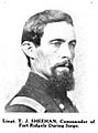
Lt. T. J. Sheehan was an officer at Fort Ripley. He helped defend Fort Ridgely during the Dakota War.
-
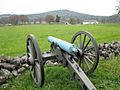
Fort Ripley had four cannons like this 12-pounder howitzer.
-
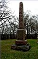
Minnesota put up a monument at Fort Ridgely to honor the Mille Lacs band of Chippewa. They helped at Fort Ripley.
-
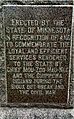
This monument was placed at Fort Ridgely in 1914. It honored the Mille Lacs band because many people visited Fort Ridgely. The Fort Ripley site was abandoned then.


