Fort Ripley, Minnesota facts for kids
Quick facts for kids
Fort Ripley
|
|
|---|---|

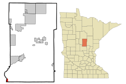
Location of the city of Fort Ripley
within Crow Wing County, Minnesota |
|
| Country | United States |
| State | Minnesota |
| County | Crow Wing |
| Area | |
| • Total | 1.40 sq mi (3.64 km2) |
| • Land | 1.29 sq mi (3.34 km2) |
| • Water | 0.11 sq mi (0.30 km2) |
| Elevation | 1,165 ft (355 m) |
| Population
(2020)
|
|
| • Total | 84 |
| • Density | 65.12/sq mi (25.14/km2) |
| Time zone | UTC-6 (Central (CST)) |
| • Summer (DST) | UTC-5 (CDT) |
| ZIP code |
56449
|
| Area code(s) | 218 |
| FIPS code | 27-21932 |
| GNIS feature ID | 2394797 |
Fort Ripley is a small city in Crow Wing County, Minnesota, United States. It is located close to where the Mississippi and Nokasippi Rivers meet. In 2020, about 84 people lived there. Fort Ripley is part of the larger Brainerd area.
Contents
History of Fort Ripley
The city of Fort Ripley gets its name from an old United States Army base. This base, also called Fort Ripley, was active from 1849 to 1877. It was located on the other side of the Mississippi River from where the city is today. The old fort is now a small part of a training area called Camp Ripley.
The city of Fort Ripley was officially started in 1927. The fort itself was named after Eleazer Wheelock Ripley. He was an American soldier and also a politician.
Geography and Location
Fort Ripley covers a total area of about 1.44 square miles (3.73 square kilometers). Most of this area is land, about 1.32 square miles (3.42 square kilometers). The rest is water, which is about 0.12 square miles (0.31 square kilometers).
Even though the city of Fort Ripley is inside Fort Ripley Township, it is its own separate place.
Nearby Rivers and Roads
Fort Ripley is located between two other cities, Little Falls and Brainerd. You can find it along Minnesota State Highway 371. There are also smaller roads nearby, like Over the Hill Road and Crow Wing County Road 2.
Several rivers are close to the city. These include the famous Mississippi River, the Nokasippi River, and the Little Nokasippi River. The border between Crow Wing County and Morrison County is also very close by.
Population and People
| Historical population | |||
|---|---|---|---|
| Census | Pop. | %± | |
| 1930 | 105 | — | |
| 1940 | 126 | 20.0% | |
| 1950 | 88 | −30.2% | |
| 1960 | 55 | −37.5% | |
| 1970 | 54 | −1.8% | |
| 1980 | 83 | 53.7% | |
| 1990 | 92 | 10.8% | |
| 2000 | 74 | −19.6% | |
| 2010 | 69 | −6.8% | |
| 2020 | 84 | 21.7% | |
| U.S. Decennial Census | |||
Fort Ripley in 2010
In 2010, there were 69 people living in Fort Ripley. These people lived in 33 different homes, and 20 of these were families. Most of the people living in the city were White (97.1%). A small number were Native American (1.4%) or Asian (1.4%).
About 21% of the homes had children under 18 living there. Many homes (54.5%) were married couples living together. About 33% of all homes were single people living alone. Some of these were people aged 65 or older.
The average age of people in the city was about 50.5 years old. About 17% of residents were under 18. Most people were between 25 and 64 years old. Slightly more males lived in the city (53.6%) than females (46.4%).
Education for Students
Students who live in Fort Ripley go to schools run by Brainerd Public Schools. The high school for students in this area is Brainerd High School.
See also
 In Spanish: Fort Ripley (Minnesota) para niños
 | Kyle Baker |
 | Joseph Yoakum |
 | Laura Wheeler Waring |
 | Henry Ossawa Tanner |

