
National Register of Historic Places listings in Denton County, Texas facts for kids

This page lists special places in Denton County, Texas, that are part of the National Register of Historic Places. This is a list of important buildings, areas, and sites that have been officially recognized for their history and culture. It's like a national "hall of fame" for old places!
In Denton County, there are 4 historic areas and 13 individual places on this list. One place used to be on the list but was later removed. Some of these places are also recognized as "Recorded Texas Historic Landmarks," which means they are important to Texas history too.
Contents
What is the National Register of Historic Places?
The National Register of Historic Places is the official list of the United States' historic places worth saving. It's managed by the National Park Service. When a place is added to the Register, it means it's important for its history, architecture, archaeology, engineering, or culture. Being on the list can help protect these places and sometimes even help get money to fix them up.
Historic Places in Denton County
Here are some of the cool historic places you can find in Denton County:
Historic Districts
These are areas with many historic buildings or features that together tell a story.
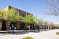
Central Roanoke Historic District
This district includes parts of North Oak Street in Roanoke. It was added to the Register in 2008. It shows what the town looked like in the past.
.jpg)
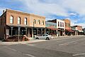
Denton County Courthouse Square Historic District
This area is around the old courthouse in Denton. It includes streets like Pecan, Austin, Walnut, and Cedar. This district was added in 2000. It's a central part of Denton's history.

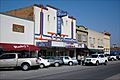
Pilot Point Commercial Historic District
This district covers parts of downtown Pilot Point, especially around the public square. It was added in 2007. It highlights the historic businesses and buildings of the town.

Individual Historic Properties
These are single buildings, sites, or structures that are important on their own.
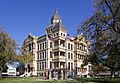
Denton County Courthouse-on-the-Square
This beautiful old courthouse is located on the Public Square in Denton. It was added to the Register in 1977. It's a very famous building in the county.

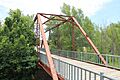
Old Alton Bridge
You can find this old bridge on Copper Canyon Road in Copper Canyon. It was added in 1988. It's a historic bridge that has been around for a long time.

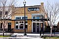
Old Continental State Bank
This building is at 109 North Oak Street in Roanoke. It was added in 1986. It's an important part of Roanoke's history.
.jpg)
Rector Road Bridge
This bridge is now located at 7501 Teasley Lane in Denton, near Guyer High School. It was added in 2004. It used to be near Sanger but was moved to keep it safe.

Archaeological Sites
Some places on the Register are not buildings but important archaeological sites. These sites are often kept secret to protect them from harm. Their addresses are usually restricted to keep them safe.
- Cranston Site (Denton) - Added in 1982.
- J. C. Lambert Site (Denton) - Added in 1982.
- Roark-Griffith Site (Denton) - Added in 1982.
- A. H. Serren Site (Denton) - Added in 1982.
- Wilson-Donaldson Site (Denton) - Added in 1982.
Historic Farms
Two farms near Lake Ray Roberts are also on the list. These farms show how people lived and worked in the past.
- Johnson Farm (Lake Ray Roberts) - Added in 1994.
- Jones Farm (Sanger) - Added in 1994.
Former Listing
Sometimes, a place is removed from the National Register. This can happen if it is moved, changed too much, or destroyed.
Gregory Road Bridge at Duck Creek
This bridge was once located near the Denton County Administrative Complex. It was added in 2004 but was removed from the list in 2014. It was delisted because it was moved incorrectly and then replaced.
Images for kids
-
A building in the Central Roanoke Historic District
-
The historic Denton County Courthouse
-
The town square in Denton, Texas
-

The Old Alton Bridge
-
The Old Continental State Bank building
-
Buildings in the Pilot Point Commercial Historic District
-
The Rector Road Bridge
