
National Register of Historic Places listings in East Baton Rouge Parish, Louisiana facts for kids

Welcome to a special list of amazing places in East Baton Rouge Parish, Louisiana! These places are so important that they are on the National Register of Historic Places. Think of it like a Hall of Fame for buildings, sites, and areas that tell us about the past.
In East Baton Rouge Parish, there are 90 different places on this list. Three of them are even more special and are called National Historic Landmarks. This means they are super important to the history of the entire United States! Some places were once on the list but have been removed, often because they were moved or changed. Let's explore some of these cool historic spots!
Historic Buildings and Schools
Many buildings in East Baton Rouge Parish have incredible stories. They show us how people lived, learned, and worked long ago.
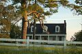
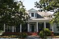
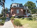
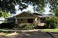
Audubon Plantation House
The Audubon Plantation House is a historic home located at 21371 Hoo Shoo Too Road in Baton Rouge, Louisiana. It was added to the National Register in 1987. This house gives us a peek into the past of plantation life in Louisiana.

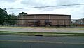
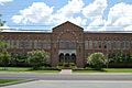
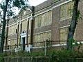
Baker High School Auditorium
The Baker High School Auditorium is found at 3200 Groom Road in Baker, Louisiana. It was recognized in 2014. This auditorium has been a central place for school events and performances for many years.

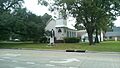
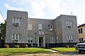
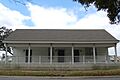
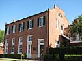
Baker Presbyterian Church
Also in Baker, the Baker Presbyterian Church at 3015 Groom Road was listed in 1990. Churches often serve as important community centers and show us the history of local groups.

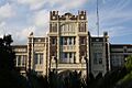
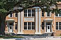
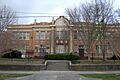
Baton Rouge Magnet High School
The Baton Rouge High School building at 2825 Government Street is a grand old school. It was added to the Register in 1986. Imagine all the students who have walked through its halls!

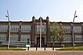
Baton Rouge Junior High School
Another historic school is the Baton Rouge Junior High School at 1100 Laurel Street. It joined the list in 1984. These old school buildings are important parts of the city's history.

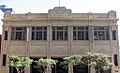
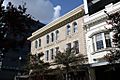
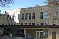
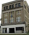
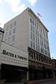
Baton Rouge Savings and Loan Association Building
This building at 400 North Boulevard was added in 2014. It shows the history of banking and business in Baton Rouge.

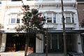
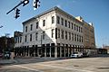
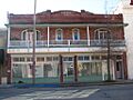
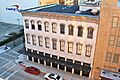
Belisle Building
The Belisle Building at 344 and 350 3rd Street was listed in 1993. It's an example of the older commercial buildings in downtown Baton Rouge.

Capital City Press Building
The Capital City Press Building at 340 Florida Street was added in 1986. This building was once home to a newspaper, telling stories of local news and events.

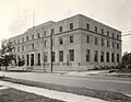
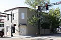
Central Fire Station
The Central Fire Station at 427 Laurel Street was listed in 1984. This building was vital for keeping the city safe from fires.
.jpg)
Dufrocq School
The Dufrocq School at 330 S. 19th Street was added in 2002. It's another important school building that has served the community for many years.

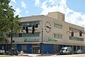
Florence Coffee House
The Florence Coffee House at 130 Main Street was listed in 1980. Coffee houses were often places where people gathered and shared ideas.

The French House (LSU)
Located on the Louisiana State University campus, The French House was added in 1982. It's a beautiful building that adds to the historic feel of the university.

Fuqua Hardware Store Building
The Fuqua Hardware Store Building at 358 3rd Street was listed in 1999. This building reminds us of the local businesses that helped communities grow.

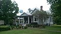
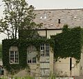
Hart House
The Hart House on Iowa Street was added in 1980. Many historic homes offer a glimpse into the daily lives of people from the past.
.jpg)
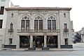
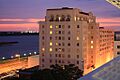
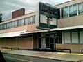
Heidelberg Hotel
The Heidelberg Hotel at 201 Lafayette Street was listed in 1982. Hotels like this were important places for travelers and visitors to the city.

Knox Building
The Knox Building at 447 3rd Street was added in 2006. It's another example of the historic architecture in downtown Baton Rouge.

Kress Building
Right next to the Knox Building, the Kress Building at 445 3rd Street was also listed in 2006. These buildings show the style of stores from long ago.

Lincoln Theater
The Lincoln Theater at 1305 Myrtle Walk was added in 2010. Theaters are special places where people gather for entertainment and community events.

McKinley High School
The old McKinley High School at 1500 East Boulevard was listed in 1981. This school has a rich history in the community.

Nicholson School
The Nicholson School at 1143 North Street was added in 1995. It's another example of a historic school building in Baton Rouge.

Old Post Office
The Old Post Office at 355 North Boulevard was listed in 1980. This building was once where people sent and received mail, connecting them to the world.

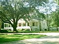
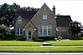
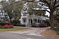
Pecue House
The Pecue House at 2260 Myrtle Avenue was added in 1994. It's a beautiful historic home that shows the architectural styles of its time.

Potts House
The Potts House at 831 North Street was listed in 1972. This house is another example of the city's residential history.

Prince Hall Masonic Temple
The Prince Hall Masonic Temple at 1335 North Boulevard was added in 1994. This building served as a meeting place for a historic organization.
.jpg)
Rabalais House
The Rabalais House at 1300 Steele Boulevard was listed in 2010. It's a more recent addition to the list of historic homes.

Reiley-Reeves House
The Reiley-Reeves House at 810 Park Boulevard was added in 1979. This house contributes to the historic character of its neighborhood.

Reymond House
The Reymond House at 7250 Goodwood Boulevard was listed in 1998. It's another example of a significant historic residence.

Roumain Building
The Roumain Building at 343 Riverside Mall was added in 1985. This building is part of the historic downtown area.

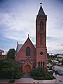
St. James Episcopal Church
The St. James Episcopal Church at 208 N. 4th Street was listed in 1978. This church is a beautiful example of historic religious architecture.

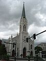
St. Joseph Cathedral
The St. Joseph Cathedral at Main and 4th Streets was added in 1990. Cathedrals are often grand buildings with long histories.

Jared Young Sanders, Jr., House
The Jared Young Sanders, Jr., House at 2332 Wisteria Street was listed in 1997. It's named after a notable person from Louisiana's past.

Scott Street School
The Scott Street School at 900 N. 19th Street was added in 1994. This school building has played a role in educating many students.

Southern University Archives Building
Located on the Southern University campus in Scotlandville, Louisiana, this building was listed in 1981. It holds important historical records.

Stewart-Dougherty House
The Stewart-Dougherty House at 741 North Street was added in 1973. It's another example of a historic home in Baton Rouge.

Tessier Buildings
The Tessier Buildings at 342, 346, and 348 Lafayette Street were listed in 1978. These buildings show the commercial history of the city.

US Post Office and Courthouse
The US Post Office and Courthouse at 707 Florida Avenue was added in 2000. This building has served as a center for government services.
.jpg)
Union Federal Savings and Loan Association
This building at 500 Laurel Street was listed in 2015. It represents the financial history of Baton Rouge.

Warden's House-Old Louisiana State Penitentiary
The Warden's House-Old Louisiana State Penitentiary at 701-705 Laurel Street was added in 1974. This building is a reminder of the state's justice system history.

Welsh-Levy Building
The Welsh-Levy Building at 455-65 3rd Street was listed in 2006. It's part of the historic downtown area.

Fonville Winans Studio
The Fonville Winans Studio at 409 N. 7th Street was added in 1999. This was the studio of a famous photographer named Fonville Winans.

Yazoo and Mississippi Valley Railroad Company Depot
The Yazoo and Mississippi Valley Railroad Company Depot at 100 S. River Road was listed in 1994. Train depots were once busy hubs for travel and trade.

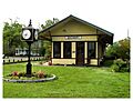
Zachary Railroad Depot
In Zachary, Louisiana, the Zachary Railroad Depot at 4434 W. Central Avenue was added in 1983. This depot is a historic landmark for the town of Zachary.

Important Historic Districts
Some areas are so full of historic buildings that the whole neighborhood is listed as a "historic district."
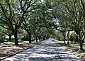
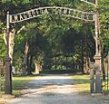
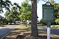
Beauregard Town Historic District
Beauregard Town Historic District in Baton Rouge is a large historic area. It was first listed in 1980. This district includes many old streets and buildings, like Front Street and Mayflower Street. It has grown over the years to include more historic parts of the city.
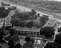
City Park Golf Course
The City Park Golf Course at 1442 City Park Avenue was added in 2002. It's a historic place for sports and recreation in Baton Rouge.

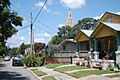
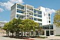
Downtown Baton Rouge Historic District
The Downtown Baton Rouge Historic District includes areas around 3rd Street and North Boulevard. It was listed in 2009. This district protects the historic look and feel of the city's center.
Drehr Place Historic District
The Drehr Place Historic District is roughly bounded by Government, 22nd, Myrtle, and St. Rose Streets. It was added in 1997. This district is part of the larger Garden District area.
Kleinert Terrace Historic District
The Kleinert Terrace Historic District is another part of the Garden District. It's roughly bounded by Myrtle Avenue, Perkins Road, Broussard Avenue, and Eugene Street. It was listed in 1998.

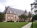
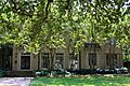
Louisiana State University Historic District
The Louisiana State University campus itself is a historic district! It was listed in 1988. The campus has many beautiful and historic buildings.

Main Street Historic District
The Main Street Historic District includes buildings from 442-660 Main Street. It was added in 1985. This area shows the history of businesses and homes along Main Street.
.jpg)
Roseland Terrace Historic District
The Roseland Terrace Historic District is bounded by Government, 18th, Myrtle, and 22nd Streets. It was listed in 1982. This neighborhood has many historic homes.

Southern University Historic District
The Southern University Historic District includes areas like Netterville Drive and Swan Avenue. It was added in 1999. This district protects the historic campus of Southern University.

Spanish Town Historic District
Spanish Town is a historic district bounded by State Capitol Drive and 5th, 9th, and North Streets. It was listed in 1978. This area has a unique history and architecture.

Virginia Street Historic District
The Virginia Street Historic District in Zachary includes 4512-4642 Virginia and 4338 Florida Streets. It was added in 2011. This district helps preserve the historic character of Zachary.
National Historic Landmarks
These three places are extra special and are recognized as National Historic Landmarks!
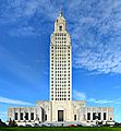
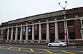
Louisiana State Capitol
The Louisiana State Capitol Building and Gardens on Capitol Drive is a National Historic Landmark. It was listed in 1978. This tall building is where Louisiana's government makes laws. It's a very important symbol of the state.

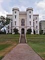
Old Louisiana State Capitol
The Old Louisiana State Capitol at North Boulevard and St. Philip Street is also a National Historic Landmark. It was listed in 1973. This building looks like a castle! It was built in the 1840s and 1850s. It was damaged during the American Civil War but was rebuilt. Today, it's a museum where you can learn about Louisiana's political history. It has cool stained glass and multimedia exhibits.

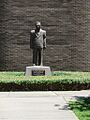
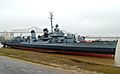
USS Kidd (DD-661)
The U.S.S. Kidd' is a historic Navy ship located on the Mississippi River near Government Street. It's a National Historic Landmark, listed in 1983. This ship is a World War II destroyer. You can visit it and learn about naval history!
,_January_2013.jpg)
Other Historic Sites
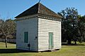
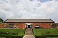
Barthel Pigeonnier
The Barthel Pigeonnier at 2161 Nicholson Drive was listed in 1983. A pigeonnier is a special building for raising pigeons. This shows a unique part of old farm life.

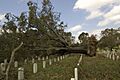
Baton Rouge National Cemetery
The Baton Rouge National Cemetery at 220 N. 19th Street was added in 1997. This is a place where soldiers are buried, honoring their service to the country.

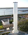
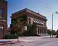
Baton Rouge Waterworks Company Standpipe
The Baton Rouge Waterworks Company Standpipe at 131 Lafayette Street was listed in 1973. This tall structure was important for providing water to the city.

LSU Campus Mounds
The LSU Campus Mounds are ancient mounds located at the junction of Dalrymple Drive and Fieldhouse Drive on the LSU campus. They were listed in 1999. These mounds are very old, possibly built by early Native American people. They are a fascinating look into ancient history.

Magnolia Cemetery
The Magnolia Cemetery is bounded by Main, 19th, Florida, and 22nd Streets. It was added in 1985. Cemeteries are often historic places that tell stories of the people who lived in a community.

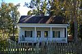
Magnolia Mound Plantation Dependency
The Magnolia Mound Plantation Dependency at 2530 Vermont Street was listed in 1977. This building was part of a larger plantation.

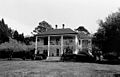
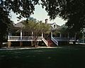
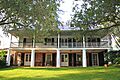
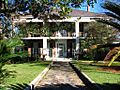
Magnolia Mound Plantation House
The main Magnolia Mound Plantation House at 2161 Nicholson Drive was listed in 1972. This house is a great example of early Louisiana architecture and life.

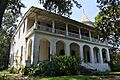
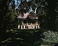
Mount Hope Plantation House
The Mount Hope Plantation House at 8151 Highland Road was added in 1980. It's another historic plantation home in the parish.

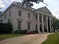
Old Louisiana Governor's Mansion
The Old Louisiana Governor's Mansion at 502 North Boulevard was listed in 1975. This was once the home of Louisiana's governors.

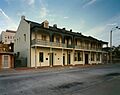
Pentagon Barracks
The Pentagon Barracks at North Riverside Mall were added in 1973. These old military barracks have a long history in Baton Rouge.

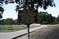
Port Hudson National Cemetery
The Port Hudson National Cemetery at 20978 Port Hickey Road in Zachary, Louisiana was listed in 1999. This cemetery was created to bury soldiers who died during the Siege of Port Hudson in the Civil War. It's a place to remember their sacrifice.

Powder Magazine
The Powder Magazine on State Capitol Drive was added in 1973. This building was used to store gunpowder long ago.

Santa Maria Plantation House
The Santa Maria Plantation House on Perkins Road, south of Baton Rouge, was listed in 1978. It's another historic plantation home.

Images for kids
-
The historic Audubon Plantation House.
-
The Baker High School Auditorium.
-
The Baker Presbyterian Church.
-
The Barthel Pigeonnier.
-
Baton Rouge High School.
-
Baton Rouge Junior High School.
-
A tree blown over in the Baton Rouge National Cemetery.
-
The Baton Rouge Savings and Loan Association Building.
-
The Baton Rouge Waterworks Company Standpipe.
-
The Belisle Building in Baton Rouge.
-
The Campbell Apartment Building.
-
The Capital City Press Building.
-
The Central Fire Station.
-
The City Park Golf Course.
-
The Cushman House.
-
A building in the Downtown Baton Rouge Historic District.
-
The Dufrocq School.
-
The Florence Coffee House.
-
The French House at LSU.
-
The Fuqua Hardware Store Building.
-
The Hart House.
-
The Heidelberg Hotel.
-
Kleinert Terrace Historic District.
-
The Knox Building.
-
The Kress Building.
-
The Lincoln Theater.
-
Longwood.
-
The Louisiana State Capitol Building.
-
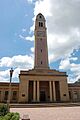
The Memorial Tower at LSU.
-

The LSU Campus Mounds.
-
Magnolia Cemetery.
-
The Magnolia Mound Plantation Dependency.
-
Magnolia Mound Plantation House.
-
Main Street Historic District.
-
The Manship House.
-
The old McKinley High School.
-
Mount Hope Plantation House.
-
The Nicholson School.
-
The Old Louisiana Governor's Mansion.
-
The Old Louisiana State Capitol.
-
The Pecue House.
-
The Pentagon Barracks.
-
Port Hudson National Cemetery.
-
The Potts House.
-
The Powder Magazine.
-
The Prince Hall Masonic Temple.
-
The Rabalais House.
-
The Reiley-Reeves House.
-
The Reymond House.
-
Roseland Terrace Historic District.
-
The Roumain Building.
-
St. James Episcopal Church.
-
St. Joseph Cathedral.
-
The Jared Young Sanders, Jr., House.
-
Santa Maria Plantation House.
-
The Scott Street School.
-
The Southern University Archives Building.
-
Southern University Historic District.
-
A building in Spanish Town.
-
The Stewart-Dougherty House.
-
The Tessier Buildings.
-
The USS Kidd (DD-661).
-
The U.S. Post Office and Courthouse.
-
The Union Federal Savings and Loan Association building.
-
The Warden's House.
-
The Welsh-Levy Building.
-
The Fonville Winans Studio.
-
The Yazoo and Mississippi Valley Railroad Company Depot.
-
The Zachary Railroad Depot.
-
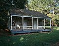
Planter's Cabin.


.jpg)

