
National Register of Historic Places listings in East Feliciana Parish, Louisiana facts for kids

Have you ever wondered about the old buildings and special places in your town or state? In East Feliciana Parish, Louisiana, there are many historic spots that are super important! These places are listed on something called the National Register of Historic Places. It's like a special list kept by the United States government to protect and celebrate buildings, sites, and objects that have a lot of history.
This list helps make sure these cool places are saved for future generations, like you! East Feliciana Parish has 32 places on this list. Two of them are even more special and are called National Historic Landmarks. Let's explore some of these amazing historical treasures!
Exploring Historic Places in East Feliciana Parish
East Feliciana Parish is full of history, from old schools to grand plantation homes and important battle sites. Each place tells a story about the past.
Historic Schools and Learning Centers
Many old schools in the parish have been recognized for their history. They show how education has changed over the years.
Clinton High Schools
- The 1903 Clinton High School is located at 11050 Bank Street in Clinton. It was built a long time ago and served students for many years.
- Another school, the 1938 Clinton High School, is at 12525 Cedar, also in Clinton. This building was used after the first one and shows how school designs changed.
- Silliman Institute on Bank Street in Clinton is another historic school. It has been an important place for learning in the community for a very long time.
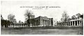
Centenary College
Centenary College in Jackson was once a college campus. It's located on College Street and has a rich history of higher education in Louisiana.
Important Public Buildings
Public buildings like courthouses are often at the heart of a community. They are where important decisions were made and where people gathered.
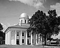
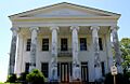
East Feliciana Parish Courthouse
The East Feliciana Parish Courthouse is on Public Square in Clinton. This building is where local laws are made and justice is served. It's a key part of the parish's government history.
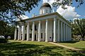
Courthouse and Lawyers' Row
In Clinton, there's a special area called the Courthouse and Lawyers' Row. It includes the courthouse and nearby buildings where lawyers used to have their offices. This area was very busy and important for the legal system in the past.
Historic Homes and Plantations
Many beautiful old homes and plantations in East Feliciana Parish are on the National Register. They offer a glimpse into how people lived many years ago.
Asphodel Plantation
Asphodel Plantation and Cemetery is south of Jackson. This old plantation includes a historic home and a cemetery, telling stories of the families who lived and worked there.
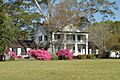
Avondale Plantation Home
The Avondale Plantation Home is east of Clinton. It's another example of the large homes that were common in this area long ago.
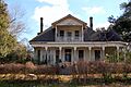
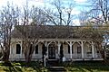
Boatner House
The Boatner House is located at Plank and Taylor Roads in Clinton. It's a historic home that shows the architectural styles of its time.
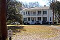
Brame-Bennett House
The Brame-Bennett House at 227 South Baton Rouge Street in Clinton is another well-preserved historic home. It has been a part of the Clinton community for many years.
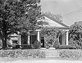
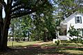
Heyman-Stewart House
The Heyman-Stewart House at 10943 Bank Street in Clinton is a historic residence that adds to the charm of the town's older buildings.
Hope Terrace
Hope Terrace is found at Church and Silliman Streets in Clinton. This house is a beautiful example of historic architecture in the area.
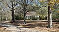
Linwood Plantation
Linwood is about 7.3 miles south of Jackson. This plantation is another significant historical property in the parish.
Marston House
The Marston House on Bank Street in Clinton is a notable historic home. It stands as a reminder of the past in the town.
Oakland Plantation House
The Oakland Plantation House is west of Gurley. It's another important plantation home on the historic register.
Wildwood Plantation House
The Wildwood Plantation House is near Louisiana Highway 68 and U.S. Route 61 in Jackson. This historic home is a part of the parish's rich plantation history.
Woodside
Woodside on St. Helena Street in Clinton is another historic house that has been preserved for its importance.
Other Notable Historic Sites
Beyond homes and schools, other unique places in East Feliciana Parish are recognized for their historical value.
Bank of Slaughter
The Bank of Slaughter at 3323 Church Street in Slaughter is a historic building that once served as a bank. It shows how towns grew and developed.
Clear Creek AME Church
The Clear Creek AME Church is near Felixville. This church is an important historical site for the local community and its religious history.
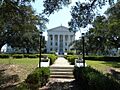
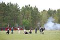
Port Hudson State Historic Site
Port Hudson is a very important place along U.S. Route 61 near Port Hudson. It was the site of the longest siege in U.S. history during the American Civil War in 1863. A siege is when an army surrounds a place to try and take it over. This site is a National Historic Landmark because of its huge importance in American history.
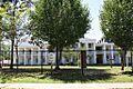
Jackson Historic District
The Jackson Historic District in Jackson includes many historic buildings. It's a whole area recognized for its historical importance, showing how the town looked and functioned long ago.
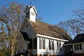
St. Andrew's Episcopal Church
St. Andrew's Episcopal Church is at Church and St. Andrew's Streets in Clinton. This church is a beautiful example of historic religious architecture.
Images for kids
-
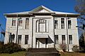
The 1903 Clinton High School building.
-
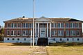
The 1938 Clinton High School building.
-
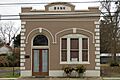
The historic Bank of Slaughter.
-
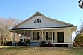
The Boatner House in Clinton.
-
The Brame-Bennett House in Clinton.
-
The Carroll House.
-
Centenary College in Jackson.
-
The Center Building of East Louisiana State Hospital.
-
The Courthouse and Lawyers' Row in Clinton.
-
The East Feliciana Parish Courthouse.
-
The Heyman-Stewart House.
-
Hope Terrace in Clinton.
-
A view of the Jackson Historic District.
-
Linwood Plantation.
-
The Marston House in Clinton.
-
Port Hudson State Historic Site.
-
St. Andrew's Episcopal Church in Clinton.
-
Silliman Institute in Clinton.
-
Woodside in Clinton.


.jpg)


