
National Register of Historic Places listings in Edmonson County, Kentucky facts for kids

Have you ever wondered about old buildings, caves, or special places that tell a story about the past? In Edmonson County, Kentucky, there are many such places! This article is about the historic sites and areas in Edmonson County that are listed on the National Register of Historic Places. This special list helps protect and celebrate important parts of American history.
The National Register of Historic Places is like a big, official list of buildings, sites, and objects that are important to the history of the United States. When a place is added to this list, it means it has a special story to tell about our country's past. It could be an old house, a church, a school, a cave, or even a whole neighborhood! Being on the list helps people understand why these places are important and encourages their protection for future generations. Edmonson County has 24 such places on this list.
Contents
Exploring Edmonson County's Historic Places
Edmonson County is famous for its amazing caves, especially within Mammoth Cave National Park. Many of the historic places on the National Register here are connected to these caves and the people who explored or lived near them.
Mammoth Cave National Park Treasures
Mammoth Cave National Park is home to the world's longest known cave system. It's no surprise that many historic listings are found right inside the park!
Amazing Cave Entrances
- Colossal Cavern Entrance: This entrance to a large cave within Mammoth Cave National Park was listed in 1991. It's a key part of the park's history.
- Crystal Cave District: Also listed in 1991, this area includes the entrance to Crystal Cave, another fascinating part of the Mammoth Cave system.
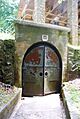
- Great Onyx Cave Entrance: This entrance, listed in 1991, leads into Great Onyx Cave, known for its beautiful cave formations.
Historic Buildings and Sites in the Park
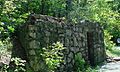
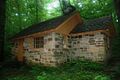
- Bransford Spring Pumphouse: Built to help manage water, this pumphouse within the park was listed in 1991.
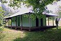
- Good Spring Baptist Church and Cemetery: This church and its cemetery, listed in 1991, show the history of communities that once lived in or near the park.
- Joppa Baptist Church and Cemetery: Another historic church and cemetery from 1991, reflecting the local history and people.
- Maintenance Area District: This area, listed in 1991, includes buildings used to maintain the park, showing how it has been cared for over the years.
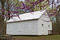
- Mammoth Cave Baptist Church and Cemetery: Listed in 1991, this church and cemetery are important parts of the park's cultural history.
- Mammoth Cave Historic District: This larger district, listed in 1991, covers a wider area within the park with many historic features.
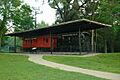
- Maple Springs Ranger Station: This station, listed in 1991, was important for park rangers doing their work.
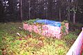
- Old Guide Cemetery: Listed in 1991, this cemetery is where some of the early cave guides and their families were buried. It tells stories of the people who first explored and shared the caves.
- Residential Area District: This district, listed in 1991, includes homes where park staff lived, showing the daily life of those who worked at Mammoth Cave.
- Superintendent's House: The house where the park superintendent lived, listed in 1991, is another important building in the park's history.
- Three Springs Pumphouse: Similar to the Bransford Spring Pumphouse, this one was also listed in 1991 and helped with water management in the park.
The Mammoth Cave Railroad
- Hercules and Coach No. 2: Imagine a train running through a national park! This historic train, including the "Hercules" engine and a passenger coach, was listed in 1975. It used to carry visitors to the Mammoth Cave area, making it easier for people to explore.
Other Important Edmonson County Sites
Beyond the national park, Edmonson County has other fascinating places on the National Register.
Ancient Rock Art
- Asphalt Rock Pictographs (15ED24): These ancient drawings on rocks, listed in 1989, are found near Asphalt, Kentucky. They give us clues about the people who lived here long, long ago.
- Dismal Rock Shelter Petroglyphs (15ED15): Also listed in 1989, these carvings in rock shelters near Sweeden, Kentucky are another amazing example of ancient art.
- Salts Cave Archeological Site: This important archaeological site, listed in 1979, is a cave that holds many secrets about early human activity in the area.
Historic Homes and Farms
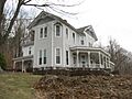
- William Ford House: This historic house, located south of Brownsville, Kentucky, was listed in 1980. It's an example of early homes in the county.
- Mill Hole Farm: West of Park City, Kentucky, this farm was listed in 1978. It shows how farming life was in the past.
- Mitchell-Estes Farmstead: This farmstead, listed in 1996, is a great example of an old farm, showing how people lived and worked the land. It even extends into Warren County, Kentucky.
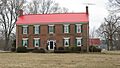
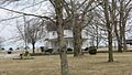
- Reed-Dorsey House: Located in Brownsville, Kentucky, this house was listed in 1986 and is another important historic home.
- Mathias Willis Store House: This old storehouse near Windyville, Kentucky, listed in 1987, tells us about local businesses and trade from long ago.
Images for kids
-
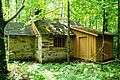
Bransford Spring Pumphouse
-

Colossal Cavern Entrance
-
Crystal Cave Ticket Office
-
William Ford House
-
Good Spring Baptist Church
-
Great Onyx Cave Entrance
-
Hercules and Coach No. 2
-

Mammoth Maintenance Area Paint-Oil House
-
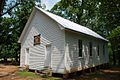
Mammoth Cave Baptist Church
-
Carmichael Entrance
-
Mitchell-Estes Farmhouse
-
Old Guide's Cemetery Walled Graves
-
Reed-Dorsey House
-

Residence 29 Mammoth Cave
-
Three Springs Pump House


