
Warren County, Kentucky facts for kids
Quick facts for kids
Warren County
|
|
|---|---|

Warren County Justice Center in Bowling Green
|
|

Location within the U.S. state of Kentucky
|
|
 Kentucky's location within the U.S. |
|
| Country | |
| State | |
| Founded | December 19, 1796 |
| Named for | Joseph Warren |
| Seat | Bowling Green |
| Largest city | Bowling Green |
| Area | |
| • Total | 548 sq mi (1,420 km2) |
| • Land | 542 sq mi (1,400 km2) |
| • Water | 6.0 sq mi (16 km2) 1.1% |
| Population
(2020)
|
|
| • Total | 134,554 |
| • Estimate
(2023)
|
142,229 |
| • Density | 245.54/sq mi (94.80/km2) |
| Time zone | UTC−6 (Central) |
| • Summer (DST) | UTC−5 (CDT) |
| Congressional district | 2nd |
Warren County is a county in the south-central part of Kentucky. In 2020, about 134,554 people lived here. This makes it the fifth-most populated county in Kentucky. The main city and county seat is Bowling Green. In 2019, new rules allowed alcohol to be sold throughout the county.
Warren County is part of the Bowling Green, KY Metropolitan Statistical Area. It is located in two natural regions: the Pennyroyal Plateau and the Western Coal Fields.
Contents
History of Warren County
Long ago, Native American villages and ancient burial mounds were found in Warren County. The first European-American explorers, called "long hunters," came in the 1770s. One of the first settlements was McFadden's Station, built in 1785. It was located on the Barren River.
Warren County became Kentucky's 23rd county in 1796. It was formed from a part of Logan County. The county was named after General Joseph Warren. He was a hero of the Revolutionary War. He sent William Dawes and Paul Revere on their famous ride. He also fought bravely at the Battle of Bunker Hill.
Warren County grew strong in farming thanks to riverboat trade. In 1859, the Louisville and Nashville Railroad (now CSX Transportation) was built through the county.
During the Civil War, most people in Warren County supported the Union. Because of its important location, Confederate soldiers took over the county in September 1861. The Union Army took it back on February 14, 1862. As the Confederates left, they destroyed railroad bridges and buildings. This was to slow down the Union soldiers.
In the 1960s and 1970s, new highways were finished. These included Interstate 65 and the Green River Parkway (now I-165). These roads brought many new businesses. Warren County changed from mostly farms to a more urban area.
In 1997, Bowling Green became a Tree City USA. This award recognizes cities that care for their trees.
Geography
Warren County covers about 548 square miles. Most of this is land, with a small part being water.
Rivers and Land Features
The Green River forms the northern border of the county. It was an important way for early settlers to travel. Other rivers and creeks flow through Warren County. These include the Barren and Gasper rivers.
The land in the north is rugged, with tall ridges. The Barren River flows through Bowling Green. It is surrounded by steep hills in some places. Several hills in Bowling Green were used for important buildings. These included forts, a hospital, and Western Kentucky University.
The land in the east is rolling, like central Kentucky. In the south and southwest, the land is mostly flat. The western part of the county has hills and rocky areas. Shanty Hollow Lake is in the northwest.
The flat areas have rich soil. This soil is good for growing crops like tobacco, hay, corn, and soybeans. Other areas have clay soil, which is rocky and not good for farming. Many people in these areas raise animals like livestock and horses.
Major Roads
- Interstate 65
- Interstate 165
- U.S. 231
- U.S. 31-W
- U.S. 68
- KY 80
- KY 185
- KY 234
- KY 880
Neighboring Counties
- Butler County - northwest
- Edmonson County - northeast
- Barren County - east
- Allen County - southeast
- Simpson County - south
- Logan County - southwest
Population Information

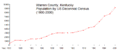
Warren County has grown a lot over the years. In 1800, there were about 4,686 people. By 2020, the population had grown to 134,554. The county continues to grow, with an estimated 142,229 people in 2023.
In 2000, there were 92,522 people living in the county. Most people were White (86.98%). Other groups included Black or African American (8.58%) and Asian (1.35%). About 2.67% of the population was Hispanic or Latino.
The average age in the county was 32 years old. Many families lived in the county, with 31.40% of households having children under 18.
Education
Warren County has two main public school districts:
- Warren County Public Schools: This district serves most of the county, including areas outside Bowling Green.
- Bowling Green Independent Schools: This district serves most of the city of Bowling Green.
High Schools
- County schools
- Greenwood High School
- Light House Academy
- Warren Central High School
- Warren East High School
- South Warren High School
- GEO International High School
- Bowling Green ISD
- Bowling Green High School
There is also a special state-run school for gifted students:
- Carol Martin Gatton Academy of Mathematics and Science in Kentucky
Private schools in the county include:
- Legacy Christian Academy
- Foundation Christian Academy
- St. Joseph School (a Catholic school)
Colleges and Universities
- Southcentral Kentucky Community and Technical College
- Western Kentucky University
Public Library
Fun Places to Visit
- Beech Bend Park: This park has roller coasters, a waterpark, and a raceway.
- Chevrolet Corvette and XLR Assembly Plant: You can take tours to see how these famous cars are made.
- Eloise B. Houchens Center: A beautiful old mansion built in 1904.
- Fort Webb Historic Park: A preserved site from the Civil War.
- Historic Railpark at the L&N Depot: A train museum with old railcars inside a 1925 train station.
- Kentucky Museum and Library: See exhibits of Kentucky history and items at Western Kentucky University.
- Lost River Cave and Valley: Explore a unique cave with the shortest and deepest river in the world. It was once a hideout for the famous outlaw Jesse James.
- National Corvette Museum: Learn all about the Chevrolet Corvette car, with models from 1953 to today.
- Riverview at Hobson Grove: A preserved mansion overlooking the Barren River, built in the mid-1800s.
- Heritage Aviation Park: A museum with displays about local pilots and their planes. You can find more information at https://www.aviationheritagepark.com/.
Communities
Cities
- Bowling Green (county seat)
- Oakland
- Plum Springs
- Smiths Grove
- Woodburn
Census-designated place
Other Small Towns and Areas
Northeast Warren
- Anna
- Bristow
- Girkin
- Glenmore
- Gotts
- Hays
- Hydro
- Kepler
- Martinsville
- Polkville
- Pondsville
- Richardsville
- Riverside
- Sunnyside
- Three Forks
- Tuckertown
Southwest Warren
- Alvaton
- Blue Level
- Boyce
- Browning
- Claypool
- Drake
- Greenhill
- Guy
- Hadley
- Hardcastle
- Lost River
- Matlock
- Memphis Junction
- Petros
- Rich Pond
- Rockfield
- Rockland
- Shawnee Estates
- Springhill
- Three Springs
Images for kids
-
Graph of Warren County population by decade
See also
 In Spanish: Condado de Warren (Kentucky) para niños
