Woodburn, Kentucky facts for kids
Quick facts for kids
Woodburn, Kentucky
|
|
|---|---|

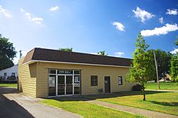
City Hall in Woodburn
|
|

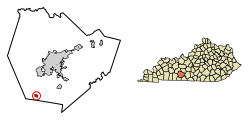
Location of Woodburn in Warren County, Kentucky.
|
|
| Country | United States |
| State | Kentucky |
| County | Warren |
| Area | |
| • Total | 0.44 sq mi (1.13 km2) |
| • Land | 0.43 sq mi (1.12 km2) |
| • Water | 0.01 sq mi (0.01 km2) |
| Elevation | 636 ft (194 m) |
| Population
(2020)
|
|
| • Total | 303 |
| • Density | 699.77/sq mi (270.25/km2) |
| Time zone | UTC-6 (Central (CST)) |
| • Summer (DST) | UTC-5 (CDT) |
| ZIP code |
42170
|
| Area code(s) | 270 |
| FIPS code | 21-84414 |
| GNIS feature ID | 0507085 |
Woodburn is a small city in Warren County, Kentucky, United States. It is a "home rule-class city," which means it has the power to manage its own local affairs. In 2020, about 303 people lived there. Woodburn is part of the larger Bowling Green area.
Contents
History of Woodburn
Woodburn started as a tiny village called "Mason's Inn." It was a resting spot for travelers using stagecoaches. These coaches traveled on a road that is now similar to U.S. Route 31W.
How Woodburn Got Its Name
People believe Woodburn got its name from a nearby forest. This forest was destroyed by a fire, leaving behind "burnt wood."
Railroad and Growth
In 1859, the L&N Railroad built a train station, called a depot, in the area. They first named it "New Woodburn." By 1864, the name was shortened to just "Woodburn."
In 1865, a town was planned right next to the train station. The city officially became a city in 1866. The oldest grave in the Woodburn Cemetery is from 1854.
Geography of Woodburn
Woodburn is located in the southwestern part of Warren County. Its exact location is 36°50′30″N 86°31′52″W / 36.84167°N 86.53111°W.
Location and Roads
The city is mainly found where three roads meet: Kentucky Route 240, U.S. Route 31W, and Kentucky Route 884. Bowling Green is to the northeast of Woodburn. Franklin is to the south.
Size of the City
According to the United States Census Bureau, Woodburn covers a total area of about 0.4 square miles (1.1 square kilometers). Almost all of this area is land.
Population Changes in Woodburn
The number of people living in Woodburn has changed over many years. Here's a look at the population from different census counts:
| Historical population | |||
|---|---|---|---|
| Census | Pop. | %± | |
| 1880 | 197 | — | |
| 1900 | 226 | — | |
| 1910 | 217 | −4.0% | |
| 1920 | 221 | 1.8% | |
| 1930 | 279 | 26.2% | |
| 1940 | 306 | 9.7% | |
| 1950 | 240 | −21.6% | |
| 1960 | 291 | 21.3% | |
| 1970 | 351 | 20.6% | |
| 1980 | 330 | −6.0% | |
| 1990 | 343 | 3.9% | |
| 2000 | 323 | −5.8% | |
| 2010 | 355 | 9.9% | |
| 2020 | 303 | −14.6% | |
| U.S. Decennial Census | |||
Population in 2000
In the year 2000, there were 323 people living in Woodburn. There were 108 households, which are groups of people living together in one home. The average number of people in each household was about 2.55.
The population was spread out by age:
- 20.1% were under 18 years old.
- 25.7% were 65 years or older.
The average age in the city was 44 years old.
Notable People from Woodburn
- Harry B. Gray (born 1935), a famous Professor of Chemistry.
See also
 In Spanish: Woodburn (Kentucky) para niños
 | Laphonza Butler |
 | Daisy Bates |
 | Elizabeth Piper Ensley |

