
National Register of Historic Places listings in Fall River, Massachusetts facts for kids
The city of Fall River, Massachusetts is home to many important buildings and places. These special spots are listed on the National Register of Historic Places. This means they are recognized for their history and importance.
-
- '
Contents
Historic Places in Fall River
Amazing Buildings and Homes
- Academy Building
- Address: S. Main St., Fall River
- Listed: July 2, 1973
- Description: This historic building has been a part of Fall River for a long time. It stands on South Main Street.

- Al Mac's Diner-Restaurant
- Address: 135 President Ave., Fall River
- Listed: December 20, 1999
- Description: Al Mac's Diner is a classic American diner. It's known for its unique style and tasty food.

- David M. Anthony House
- Address: 368 N. Main St., Fall River
- Listed: February 16, 1983
- Description: This house belonged to David M. Anthony. It's a great example of old homes in Fall River.

- Ashley House
- Address: 3159 Main St., Fall River
- Listed: February 16, 1983
- Description: The Ashley House was a historic home. Sadly, it was taken apart in July 1983.

- Belmont Club/John Young House
- Address: 34 Franklin St., Fall River
- Listed: February 16, 1983
- Description: This building has served as both the Belmont Club and the John Young House. It's a significant part of the city's past.

- Barnabus Blossom House
- Address: 244 Grove St., Fall River
- Listed: February 16, 1983
- Description: The Barnabus Blossom House is another historic home. It shows how people lived long ago in Fall River.

- A.J. Borden Building
- Address: 91–111 S. Main St., Fall River
- Listed: February 16, 1983
- Description: This building, named after A.J. Borden, is an important part of Fall River's downtown area.

- Ariadne J. and Mary A. Borden House
- Address: 92 Globe St., Fall River
- Listed: February 16, 1983
- Description: This house was once home to Ariadne J. and Mary A. Borden. It's a beautiful historic residence.

- Borden-Winslow House
- Address: 3063 N. Main St., Fall River
- Listed: February 16, 1983
- Description: The Borden-Winslow House is a historic home on North Main Street. It has a long history in the city.

- Hathaway Brightman House
- Address: 205 Crescent St., Fall River
- Listed: February 16, 1983
- Description: This house, the Hathaway Brightman House, is a notable historic building in Fall River.

- Squire William B. Canedy House
- Address: 2634 N. Main St., Fall River
- Listed: February 16, 1983
- Description: The Squire William B. Canedy House is a grand old home. It tells a story of the city's past residents.

- William C. Davol Jr. House
- Address: 252 High St., Fall River
- Listed: February 16, 1983
- Description: This house belonged to William C. Davol Jr. It's a significant part of the historic High Street.

- John M. Earle House
- Address: 352 Durfee St., Fall River
- Listed: February 16, 1983
- Description: The John M. Earle House is a historic residence. It adds to the rich history of Fall River's homes.

- James D. Hathaway House
- Address: 311 Pine St., Fall River
- Listed: February 16, 1983
- Description: The James D. Hathaway House is a beautiful historic home. It's located on Pine Street.

- House at 108–112 Quarry Street
- Address: 108–112 Quarry St., Fall River
- Listed: February 16, 1983
- Description: This group of houses on Quarry Street is recognized for its historical value.

- Lafayette-Durfee House
- Address: 94 Cherry St., Fall River
- Listed: April 15, 1982
- Description: The Lafayette-Durfee House is a very old and important home. It has a long history in Fall River.

- William Lindsey House
- Address: 373 N. Main St., Fall River
- Listed: February 16, 1983
- Description: The William Lindsey House is another historic home on North Main Street.

- William M. Manley House
- Address: 610 Cherry St., Fall River
- Listed: June 26, 1986
- Description: This house, built for William M. Manley, is a significant historic residence in the city.

- Nathan Read House
- Address: 506 N. Main St., Fall River
- Listed: February 16, 1983
- Description: The Nathan Read House is a historic home that stands on North Main Street.

- John Mace Smith House
- Address: 399 N. Main St., Fall River
- Listed: February 16, 1983
- Description: The John Mace Smith House is a historic building. It adds to the charm of Fall River's older neighborhoods.

- Valentine-French House
- Address: 5105 N. Main St., Fall River
- Listed: February 16, 1983
- Description: The Valentine-French House is a historic home located on North Main Street.

- Luther Winslow Jr. House
- Address: 5225 N. Main St., Fall River
- Listed: February 16, 1983
- Description: This house, built for Luther Winslow Jr., is another important historic home in Fall River.

Important Mills and Factories
- Algonquin Printing Co.
- Address: Bay St., Fall River
- Listed: February 16, 1983
- Description: The Algonquin Printing Company was an important factory. It played a big role in Fall River's history.

- American Printing Co. and Metacomet Mill
- Address: Anawan St., Fall River
- Listed: February 16, 1983
- Description: These two mills were a major part of Fall River's textile industry. They helped the city grow.

- Barnard Mills
- Address: 641–657 Quarry St., Fall River
- Listed: February 16, 1983
- Description: Barnard Mills was a large textile factory. It included a special building for weaving cloth.

- Border City Mill No. 2
- Address: One Weaver St., Fall River
- Listed: June 28, 1990
- Description: Border City Mill No. 2 was a textile mill. Today, it has been turned into apartments.

- Chace Mills
- Address: Lewiston and Salem Sts., Fall River
- Listed: February 16, 1983
- Description: Chace Mills was a large factory complex. Part of it burned in 1999, but the main mill was saved.

- Oliver Chace's Thread Mill
- Address: 505 Bay St., Fall River
- Listed: February 16, 1983
- Description: This is the oldest mill still standing in Fall River! It was later part of Connanicut Mills.

- Charlton Mill
- Address: 109 Howe St., Fall River
- Listed: February 16, 1983
- Description: Charlton Mill was an important factory. Its weaving shed was taken down.

- Cornell Mills
- Address: Alden St., Fall River
- Listed: February 16, 1983
- Description: Cornell Mills was a large textile factory. It played a big role in Fall River's industrial past.

- Crescent Mill
- Address: 30 Front St., Fall River
- Listed: February 16, 1983
- Description: Crescent Mill is a historic factory building. It stands near the waterfront.

- Durfee Mills
- Address: 359–479 Pleasant St., Fall River
- Listed: February 16, 1983
- Description: Durfee Mills was the largest group of factories in Fall River. It was very important for making textiles.

- Fall River Bleachery
- Address: Jefferson St., Fall River
- Listed: February 16, 1983
- Description: The Fall River Bleachery was a place where fabrics were treated and made ready for use.

- Flint Mills
- Address: Alden St., Fall River
- Listed: February 16, 1983
- Description: Flint Mills was another significant textile factory in Fall River.

- Foster Spinning Co.
- Address: Cove St., Fall River
- Listed: February 16, 1983
- Description: The Foster Spinning Company was a mill where thread was made.

- Globe Yarn Mills
- Address: Globe St., Fall River
- Listed: February 16, 1983
- Description: Globe Yarn Mills was a large factory that produced yarn.

- Hargraves Mill No. 1
- Address: Quarry St., Fall River
- Listed: February 16, 1983
- Description: Hargraves Mill No. 1 was an important part of the city's textile industry.

- King Philip Mills
- Address: Kilburn St., Fall River
- Listed: February 16, 1983
- Description: King Philip Mills was a large factory. Its office building was destroyed by fire in 2012.

- Mechanics Mill
- Address: 1082 Davol St., Fall River
- Listed: February 16, 1983
- Description: Mechanics Mill is a historic factory building. It stands on Davol Street.

- Narragansett Mills
- Address: 1567 N. Main St., Fall River
- Listed: February 16, 1983
- Description: Narragansett Mills was another large textile factory in Fall River.

- Pilgrim Mills
- Address: 847 Pleasant St., Fall River
- Listed: February 16, 1983
- Description: Pilgrim Mills was a historic factory that helped make Fall River famous for textiles.

- Sagamore Mill No. 2
- Address: 1822 N. Main St., Fall River
- Listed: February 16, 1983
- Description: Sagamore Mill No. 2 is a historic factory building on North Main Street.

- Sagamore Mills No. 1 and No. 3
- Address: Ace St., Fall River
- Listed: February 16, 1983
- Description: These two Sagamore Mills were also important parts of Fall River's textile industry.

- Sanford Spinning Co.
- Address: Globe Mills Ave., Fall River
- Listed: February 16, 1983
- Description: The Sanford Spinning Company was a mill that spun yarn. It also included Globe Yarn Mills No. 3.

- Seaconnett Mills
- Address: E. Warren St., Fall River
- Listed: February 16, 1983
- Description: Seaconnett Mills was a historic factory. It helped produce textiles in Fall River.

- Stafford Mills
- Address: County St., Fall River
- Listed: February 16, 1983
- Description: Stafford Mills was a large textile factory. It's a key part of the city's industrial past.

- Union Mills
- Address: Pleasant St., Fall River
- Listed: February 16, 1983
- Description: Union Mills was another important factory in Fall River. It contributed to the city's textile production.

- Wampanoag Mills
- Address: Quequechan St., Fall River
- Listed: February 16, 1983
- Description: Wampanoag Mills was a large textile factory. It's named after the Wampanoag people.

Schools and Churches with History
- N. B. Borden School
- Address: 43 Morgan St., Fall River
- Listed: February 16, 1983
- Description: The N. B. Borden School is a historic school building. It has educated many students over the years.

- B.M.C. Durfee High School (1886 building)
- Address: 289 Rock St., Fall River
- Listed: June 11, 1981
- Description: This old high school building is now used by the Massachusetts Probate Court. It's a beautiful example of old school architecture.

- William M. Connell School
- Address: 650 Plymouth Ave., Fall River
- Listed: February 16, 1983
- Description: The William M. Connell School is a historic school building in Fall River.

- Coughlin School
- Address: 1975 Pleasant St., Fall River
- Listed: February 16, 1983
- Description: Coughlin School is a historic educational building. It has served the community for many years.

- Davol School
- Address: 112 Flint St., Fall River
- Listed: February 16, 1983
- Description: Davol School closed in 2008. It is now owned by the Flint Neighborhood Association.

- Notre Dame School
- Address: 34 St. Joseph's St., Fall River
- Listed: February 16, 1983
- Description: Notre Dame School is a historic school building. It closed its doors in June 2008.

- Osborn Street School
- Address: 160 Osborn St., Fall River
- Listed: February 16, 1983
- Description: The Osborn Street School is a historic building that once served as a school.

- Pine Street School
- Address: 880 Pine St., Fall River
- Listed: February 16, 1983
- Description: The Pine Street School is another historic school building in Fall River.

- Sacred Heart School
- Address: 90 Linden St., Fall River
- Listed: March 9, 1987
- Description: Sacred Heart School is a historic school building. It has been an important part of the community.

- Brayton Methodist Episcopal Church
- Address: 264 Griffin St., Fall River
- Listed: February 16, 1983
- Description: This church is a historic place of worship. It has served its community for many years.

- Central Congregational Church
- Address: 100 Rock St., Fall River
- Listed: February 16, 1983
- Description: This church building was most recently used by the International Institute of Culinary Arts.

- Church of the Ascension
- Address: 160 Rock St., Fall River
- Listed: February 16, 1983
- Description: The Church of the Ascension is a beautiful historic church.

- First Baptist Church
- Address: 200–228 N. Main St., Fall River
- Listed: February 16, 1983
- Description: The First Baptist Church is a historic place of worship. It stands on North Main Street.

- North Christian Congregational Church
- Address: 3538 N. Main St., Fall River
- Listed: February 16, 1983
- Description: This church is a historic landmark. It has a tall steeple and beautiful architecture.

- Santo Christo Church
- Address: 240 Columbia St., Fall River
- Listed: February 16, 1983
- Description: Santo Christo Church is a historic place of worship. It is an important part of the community.

- St. Anne's Church and Parish Complex
- Address: 780 S. Main St., Fall River
- Listed: February 16, 1983
- Description: St. Anne's Church is a large and impressive historic church complex.

- St. Joseph's Church
- Address: 1355 N. Main St., Fall River
- Listed: February 16, 1983
- Description: St. Joseph's Church is a historic church building on North Main Street.

- St. Louis Church
- Address: 440 Bradford Ave., Fall River
- Listed: February 16, 1983
- Description: St. Louis Church was a historic church. It was taken down in April 2010.

- St. Mary's Cathedral and Rectory
- Address: 327 Second St., Fall River
- Listed: February 16, 1983
- Description: St. Mary's Cathedral is a very important church in Fall River. It includes the rectory, where the priests live.

- St. Patrick's Church
- Address: 1588 S. Main St., Fall River
- Listed: February 16, 1983
- Description: St. Patrick's Church is now known as Good Shepherd Parish. It's a historic place of worship.

- The Unitarian Society
- Address: 309 N. Main St., Fall River
- Listed: May 13, 1982
- Description: This historic church was destroyed by fire in 1983 but was rebuilt.

Other Interesting Historic Sites
- Borden Flats Light Station
- Address: Taunton River, Fall River
- Listed: June 15, 1987
- Description: This lighthouse stands in the Taunton River. It has guided ships for many years.

- Bristol County Superior Court
- Address: 441 N. Main St., Fall River
- Listed: February 16, 1983
- Description: This is the main courthouse for Bristol County. It's a grand building where important legal decisions are made.

- Cataract Engine Company No. 3
- Address: 116 Rock St., Fall River
- Listed: February 16, 1983
- Description: This old fire station housed the Cataract Engine Company No. 3. It's a piece of Fall River's firefighting history.

- Children's Home
- Address: 427 Robeson St., Fall River
- Listed: February 16, 1983
- Description: The Children's Home was a place that cared for children in need. It has a long history of helping the community.

- Fall River Waterworks
- Address: Bedford St., Fall River
- Listed: December 7, 1981
- Description: The Fall River Waterworks supplied water to the city. It's an important part of the city's infrastructure history.

- Greany Building
- Address: 1270–1288 Pleasant St., Fall River
- Listed: February 16, 1983
- Description: The Greany Building is a historic commercial building. It has been a part of the city's business life.

- Jesus Marie Convent
- Address: 138 St. Joseph's St., Fall River
- Listed: February 16, 1983
- Description: The Jesus Marie Convent is a historic religious building.

- Kennedy Park
- Address: Bounded by S. Main St., Bradford Ave., Middle, and Bay Sts., Fall River
- Listed: February 16, 1983
- Description: Kennedy Park is a large historic park in Fall River. It's a place for recreation and relaxation.

- Massasoit Fire House No. 5
- Address: 83 Freedom St., Fall River
- Listed: February 16, 1983
- Description: This old fire station, Massasoit Fire House No. 5, is a historic building.

- North Burial Ground
- Address: N. Main St. between Brightman and Cory Sts., Fall River
- Listed: February 16, 1983
- Description: This historic cemetery is a quiet place. Many people from Fall River's past are buried here.

- Oak Grove Cemetery
- Address: 765 Prospect St., Fall River
- Listed: February 16, 1983
- Description: Oak Grove Cemetery is another historic cemetery in Fall River. It's a peaceful place with old trees.

- Osborn House
- Address: 456 Rock St., Fall River
- Listed: April 4, 1980
- Description: Also known as the Carr-Osborn Mansion, this is a grand historic house.

- Israel Picard House
- Address: 690 County St., Fall River
- Listed: February 16, 1983
- Description: The Israel Picard House is a historic home that adds to the city's architectural heritage.

- Pocasset Firehouse No. 7
- Address: 1058 Pleasant St., Fall River
- Listed: February 16, 1983
- Description: This historic firehouse, Pocasset Firehouse No. 7, served the community for many years.

- PT Boat 796 (torpedo boat)
- Address: Battleship Cove, Fall River
- Listed: January 14, 1986
- Description: This PT boat is a historic military vessel. It's part of the amazing collection at Battleship Cove.

- Quequechan Club
- Address: 306 N. Main St., Fall River
- Listed: February 16, 1983
- Description: The Quequechan Club is a historic social club building.

- Ruggles Park
- Address: Bounded by Seabury, Robeson, Pine, and Locust Sts., Fall River
- Listed: February 16, 1983
- Description: Ruggles Park is a historic green space in Fall River. It's a place for people to enjoy nature.

- St. Joseph's Orphanage
- Address: 56 St. Joseph's St., Fall River
- Listed: February 16, 1983
- Description: St. Joseph's Orphanage was a historic institution that cared for children.

- Truesdale Hospital
- Address: 1820 Highland Ave., Fall River
- Listed: April 15, 1986
- Description: Truesdale Hospital was a historic medical facility. It served the health needs of the community.

- U.S.S. Joseph P. Kennedy Jr. (DD-850)
- Address: Battleship Cove, Fall River
- Listed: September 30, 1976
- Description: This historic destroyer is part of Battleship Cove. It's a powerful ship with a long history.

- U.S.S. Lionfish
- Address: Battleship Cove, Fall River
- Listed: September 30, 1976
- Description: The U.S.S. Lionfish is a historic submarine. You can visit it at Battleship Cove.
.jpg)
- U.S.S. Massachusetts
- Address: Battleship Cove, Fall River
- Listed: September 30, 1976
- Description: The U.S.S. Massachusetts is a famous battleship. It's a huge ship and a major attraction at Battleship Cove.

- Woman's Club of Fall River
- Address: 1542 Walnut St., Fall River
- Listed: February 16, 1983
- Description: This historic building was home to the Woman's Club of Fall River. It was a place for women to gather and work for their community.

Historic Districts to Explore
- Boguslavsky Triple-Deckers
- Address: 53–87 Albion St., Fall River
- Listed: February 16, 1983
- Description: This area features historic "triple-decker" homes. These are multi-story houses common in New England.

- A. B. Chace Rowhouses
- Address: 655–685 Middle St., Fall River
- Listed: February 16, 1983
- Description: These rowhouses were built by A. B. Chace. They are historic homes connected in a row.

- Chase-Hyde Farm
- Address: 1281–1291 New Boston Rd., Fall River
- Listed: February 16, 1983
- Description: The Chase-Hyde Farm is a historic farm property. It shows what farming life was like in the past.

- Corky Row Historic District
- Address: Roughly bounded by Plymouth Ave. I195 and 2nd St., Fall River
- Listed: June 23, 1983
- Description: This historic area includes old factories like Davol Mills and Tecumseh Mills. It's a look into Fall River's industrial past.

- Downtown Fall River Historic District
- Address: N. and S. Main, Bedford, Granite, Bank, Franklin, and Elm Sts., Fall River
- Listed: February 16, 1983
- Description: This district covers the historic heart of Fall River. It includes many important buildings and streets.

- Highlands Historic District
- Address: Roughly bounded by June, Cherry, and Weetamae Sts., Lincoln, Highland, President, N. Main, and Hood Aves., Fall River
- Listed: February 16, 1983
- Description: The Highlands is a historic neighborhood. It has many beautiful old homes and streets.

- Lower Highlands Historic District
- Address: Roughly bounded by Cherry, Main, Winter, and Bank Sts., Fall River
- Listed: January 10, 1984
- Description: This area is part of the historic Highlands. It has many old buildings and a unique feel.

- Quequechan Valley Mills Historic District
- Address: Quequechan, Jefferson, and Stevens Sts. between I-195 and Denver St., Fall River
- Listed: February 16, 1983
- Description: This district includes many old mills located along the Quequechan River. It shows how important the river was for factories.

Images for kids
-
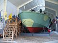
Torpedo Boat PT-617 at Battleship Cove.


All content from Kiddle encyclopedia articles (including the article images and facts) can be freely used under Attribution-ShareAlike license, unless stated otherwise. Cite this article:
National Register of Historic Places listings in Fall River, Massachusetts Facts for Kids. Kiddle Encyclopedia.