
National Register of Historic Places listings in Hampshire County, Massachusetts facts for kids

Welcome to Hampshire County, Massachusetts! This page is all about special places here that are listed on the National Register of Historic Places. Think of this register as a super important list of buildings, areas, and sites across the United States that are worth saving because of their history or cool architecture.
When a place is on this list, it means it's recognized for being a big part of our country's story. It helps protect these places and makes people more aware of their value. In Hampshire County, there are 82 amazing spots on this list! Three of them are even more special, called National Historic Landmarks.
-
- '
Contents
- What is the National Register of Historic Places?
- Historic Places in Amherst
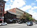
- Amherst Central Business District
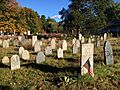
- Amherst West Cemetery
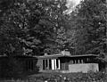
- Theodore Baird Residence
- Conkey-Stevens House
- Cushman Village Historic District
- Dickinson Historic District
- Emily Dickinson Museum
- East Village Historic District
- Goodwin Memorial African Methodist Episcopal Zion Church
- Lincoln-Sunset Historic District
- North Amherst Center Historic District
- Old Chapel (Amherst, Massachusetts)
- Prospect-Gaylord Historic District
- South Amherst Common Historic District
- Strong House (Amherst, Massachusetts)
- Westside Historic District
- Historic Places in Other Towns
- Belchertown Center Historic District
- Belchertown State School
- Bisbee Mill (Chesterfield)
- William Cullen Bryant Homestead (Cummington)
- Center Cemetery (Southampton)
- Center Cemetery (Worthington)
- Chesterfield Center Historic District
- Church Street Historic District (Ware)
- Calvin Coolidge House (Northampton)
- Dorsey-Jones House (Northampton)
- Elm Street Historic District (Hatfield)
- Fort Hill Historic District (Northampton)
- Gate Cemetery (Chesterfield)
- Grove Hill Mansion (Northampton)
- Hadley Center Historic District
- Hatfield Center Historic District
- Haydenville Historic District (Williamsburg)
- Hockanum Rural Historic District (Hadley)
- Huntington Village Historic District
- Ireland Street Cemetery (Chesterfield)
- Lockville Historic District (Southampton)
- Main Street Historic District (Easthampton)
- The Manse (Northampton)
- Middlefield-Becket Stone Arch Railroad Bridge District
- Middlefield Center Historic District
- Mill-Prospect Street Historic District (Hatfield)
- Miss Florence Diner (Northampton)
- Mountain Rest (Goshen)
- Nashawannuck Mills Historic District (Easthampton)
- North Cemetery (Worthington)
- North Hadley Historic District
- North Hatfield Historic District
- Northampton Downtown Historic District
- Northampton State Hospital
- Northampton Veterans Administration Hospital Historic District
- Old Mill Site Historic District (Hatfield)
- Otis Company Mill No. 1 (Ware)
- Parsons, Shepherd, and Damon Houses Historic District (Northampton)
- Pelham Town Hall Historic District
- Plainfield Center Historic District
- Porter-Phelps-Huntington House (Hadley)
- Ringville Cemetery (Worthington)
- Ross Farm (Northampton)
- Smith Alumnae Gymnasium (Northampton)
- South Hadley Canal Historic District
- South Worthington Historic District
- Southampton Center Historic District
- The Town Farm (Easthampton)
- Upper Main Street Historic District (Hatfield)
- US Post Office-Easthampton Main
- US Post Office-South Hadley Main
- Walker-Collis House (Belchertown)
- Ware Center Historic District
- Ware Millyard Historic District
- Ware Town Hall
- Ware-Hardwick Covered Bridge
- West Chesterfield Historic District
- West Hatfield Historic District
- Williamsburg Center Historic District
- Woodbridge Street Historic District (South Hadley)
- Images for kids
What is the National Register of Historic Places?
The National Register of Historic Places is like a hall of fame for historic buildings, structures, objects, sites, and districts. It's managed by the National Park Service. Being on the list means a place is important to local, state, or national history. It encourages people to preserve these treasures for future generations.
Historic Places in Amherst
Amherst is home to many historic spots!
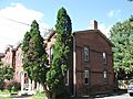
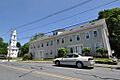
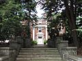
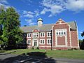
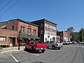
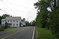
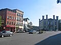
Amherst Central Business District
This area includes the main streets of Amherst, like Main Street and Pleasant Street. It's a historic district, meaning a whole group of buildings and streets are important together. Many of these buildings show how the town grew over time.
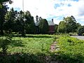
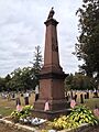
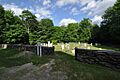
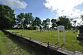
Amherst West Cemetery
Even cemeteries can be historic! The Amherst West Cemetery on Triangle Street is on the list. Old cemeteries often tell stories about the people who lived in a town long ago. You can find very old gravestones and learn about early settlers.
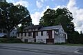
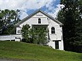
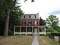
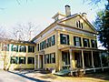
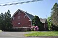
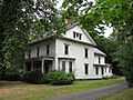
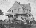
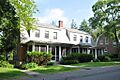
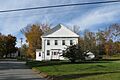
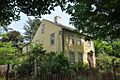
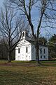
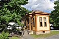
Theodore Baird Residence
The Baird House on Shays Street is a historic home. It was built in 1939 and is a great example of modern architecture from that time.
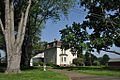
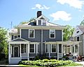
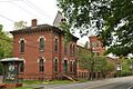
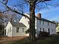
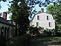
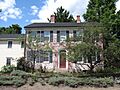
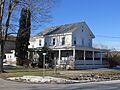
Conkey-Stevens House
This house on Main Street is another historic home in Amherst. It was built in 1827 and shows the style of homes from the early 1800s.
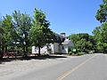
Cushman Village Historic District
This district is a historic neighborhood roughly bounded by East Leverett Road and Pine, Henry, Bridge, and State Streets. It shows how a small village developed.
Dickinson Historic District
This area includes Kellogg Avenue, Main, Gray, and Lessey Streets. It's named after the famous poet Emily Dickinson, whose home is also in Amherst.
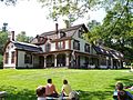
Emily Dickinson Museum
The Emily Dickinson Museum at 280 Main Street is a National Historic Landmark. This was the home of the famous American poet, Emily Dickinson. She lived most of her life here and wrote many of her poems in this house. It's a very important place for literature lovers.
East Village Historic District
This historic district includes Main, North, and South East Streets. It shows the early development of Amherst's East Village.
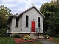
Goodwin Memorial African Methodist Episcopal Zion Church
This church on Woodside Avenue is a significant historic building. It represents an important part of the community's history and religious life.
Lincoln-Sunset Historic District
This district includes Lincoln Avenue, Northampton Road, and Fearing Street. It features many historic homes and buildings that show the growth of Amherst.
North Amherst Center Historic District
This district includes North Pleasant Street, Pine Street, and Meadow Street. It's the historic heart of North Amherst, with buildings that tell the story of this part of town.
Old Chapel (Amherst, Massachusetts)
The Old Chapel at 144 Hicks Way is one of the oldest buildings at the University of Massachusetts Amherst. It's a beautiful and important part of the university's history.
Prospect-Gaylord Historic District
This area includes Prospect Street, Gaylord Street, and Amity Street. It's another neighborhood with many historic homes and buildings.
South Amherst Common Historic District
This district includes Shays Street, South Amherst Common, South East Street, and Pomeroy Lane. It's centered around the historic common, which was a central gathering place for the community.
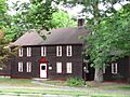
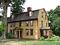
Strong House (Amherst, Massachusetts)
The Strong House at 67 Amity Street is a historic home built in 1744. It's one of the oldest houses in Amherst and shows early colonial architecture.
Westside Historic District
This district includes Baker and Snell Streets, Northampton Road, and Hazel Avenue. It's a historic residential area with many interesting old homes.
Historic Places in Other Towns
Belchertown Center Historic District
In Belchertown, this district includes Main, Maple, Walnut, Park, and Jabish Streets. It shows the historic center of the town, with many buildings from its early days.
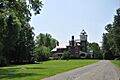
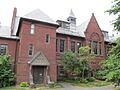
Belchertown State School
The Belchertown State School at 30 State Street is a historic property. It was once a large school and institution, and its buildings tell a story of how care and education were provided in the past.
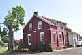
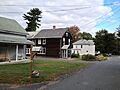
Bisbee Mill (Chesterfield)
The Bisbee Mill at 66 East Street in Chesterfield is a historic mill. Mills were very important in the past for processing goods and powering industries.
William Cullen Bryant Homestead (Cummington)
This homestead, located about 2 miles from Cummington, is a National Historic Landmark. It was the home of William Cullen Bryant, a famous American poet and journalist. Visiting his home is like stepping back in time to see where he lived and worked.
Center Cemetery (Southampton)
The Center Cemetery at 178 College Highway in Southampton is a historic burial ground. It holds the stories of many early residents of the town.
Center Cemetery (Worthington)
Another historic cemetery, this one is on Sam Hill Road in Worthington. It's a quiet place that connects us to the past.
Chesterfield Center Historic District
This district includes Main Road, South Street, North Road, Bagg Road, and Bryant Street in Chesterfield. It shows the historic heart of the town.
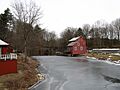
Church Street Historic District (Ware)
In Ware, this district covers Church Street between Park Avenue and Highland Street. It features many historic buildings, including churches and homes.
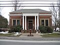
Calvin Coolidge House (Northampton)
The Calvin Coolidge House at 19-21 Massasoit Street in Northampton was the home of Calvin Coolidge, who became the 30th President of the United States. It's a simple home for such an important person!
Dorsey-Jones House (Northampton)
This house at 191 Nonotuck Street in Northampton is part of the Underground Railroad in Massachusetts. It was a safe house for people escaping slavery, making it a very important site for American history.
Elm Street Historic District (Hatfield)
This district includes Elm, Sunset, and Scotland Streets, and Little Neponset Road in Hatfield. It's a historic neighborhood with many interesting old homes.
Fort Hill Historic District (Northampton)
This district in Northampton is roughly along South Street from Lyman Street to Monroe Street. It's a historic residential area.
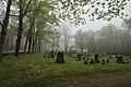
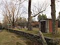
Gate Cemetery (Chesterfield)
The Gate Cemetery on Ireland Street in Chesterfield is another historic cemetery.
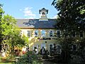
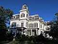
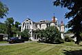
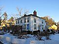
Grove Hill Mansion (Northampton)
The Grove Hill Mansion at Florence Road and Front Street in Northampton is a grand historic home. It shows the architectural styles of wealthy families from the past.
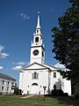
Hadley Center Historic District
This district in Hadley includes Middle and Russell Streets. It's the historic center of Hadley, with many well-preserved buildings.
Hatfield Center Historic District
This district in Hatfield is roughly bounded by the Connecticut and Mill Rivers and Day Avenue. It's the historic core of the town.
Haydenville Historic District (Williamsburg)
In Williamsburg, this district includes Main and High Streets, and Kingsley Avenue. It's a historic village area.
Hockanum Rural Historic District (Hadley)
This district in Hadley is around Hockanum Road, from Hockanum Cemetery to Skinner State Park. It shows the rural history of the area.
Huntington Village Historic District
This district in Huntington is along East Main, Main, Russell, Upper Russell, and Basket Streets. It's the historic center of Huntington.
Ireland Street Cemetery (Chesterfield)
Another historic cemetery on Ireland Street in Chesterfield.
Lockville Historic District (Southampton)
This district on College Highway in Southampton is a historic industrial area. It shows the importance of water power and mills in the past.
Main Street Historic District (Easthampton)
In Easthampton, this district covers Main Street between Northampton and Center Streets. It's the historic downtown area.
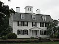
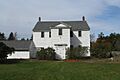
The Manse (Northampton)
The Manse at 54 Prospect Street in Northampton is a historic home. It was built in 1803 and is a great example of early 19th-century architecture.
Middlefield-Becket Stone Arch Railroad Bridge District
Near Middlefield, this district includes impressive stone arch railroad bridges. These bridges are amazing examples of engineering from the past.
Middlefield Center Historic District
This district in Middlefield includes Skyline Trail and Bell Road. It's the historic center of the town.
Mill-Prospect Street Historic District (Hatfield)
This district in Hatfield includes Prospect, Chestnut, Bridge, School Streets, Raymond Avenue, and Prospect Court. It's a historic neighborhood.
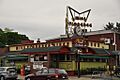
Miss Florence Diner (Northampton)
The Miss Florence Diner at 99 Main Street in Northampton is a classic American diner. It's a great example of the diners that became popular in the mid-20th century.
Mountain Rest (Goshen)
Mountain Rest on Wildwood Lane off Spruce Corner Road in Goshen was an early 19th-century missionary retreat camp. It has a unique history as a place for quiet reflection.
Nashawannuck Mills Historic District (Easthampton)
This district at 1-15 Cottage Street in Easthampton was once a busy mill complex. It shows the industrial history of the town.
North Cemetery (Worthington)
The North Cemetery on Cold Street in Worthington is another historic cemetery.
North Hadley Historic District
This district in Hadley is along River Drive, Stockwell Road, Stockbridge Street, French Street, Meadow Street, and Mount Warner Street. It shows the historic rural landscape of North Hadley.
North Hatfield Historic District
This district in Hatfield is along West Street and Depot Road. It's a historic area that grew around the railroad.
Northampton Downtown Historic District
This large district in Northampton includes many streets like Hampton, Pearl, Strong, Bedford, Elm, and areas near the railroad tracks. It's the vibrant historic downtown of Northampton.
Northampton State Hospital
The Northampton State Hospital at 1 Prince Street was a large hospital complex. While many buildings were taken down, its history is still recognized.
Northampton Veterans Administration Hospital Historic District
This district at 421 North Main Street in Northampton is a historic hospital complex that served veterans.
Old Mill Site Historic District (Hatfield)
This district at 48 and 50 Prospect Street in Hatfield is a historic mill site. It shows where early industries operated.
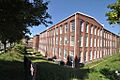
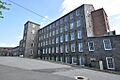
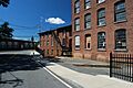
Otis Company Mill No. 1 (Ware)
The Otis Company Mill No. 1 on East Main Street in Ware was an important mill. It played a big role in the town's industrial past.
Parsons, Shepherd, and Damon Houses Historic District (Northampton)
This district at 46, 58, and 66 Bridge Street in Northampton includes several historic homes. The 1719 Parsons House is a very old and important building.
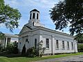
Pelham Town Hall Historic District
This district in Pelham is at Amherst Road and Daniel Shays Highway. It includes the historic town hall, a central building for local government.
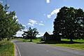
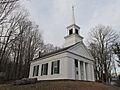
Plainfield Center Historic District
This district in Plainfield includes parts of Church Lane, Broom, Central, Main, Pleasant, and Union Streets. It's the historic center of Plainfield.
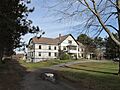
Porter-Phelps-Huntington House (Hadley)
The Porter-Phelps-Huntington House at 130 River Drive in Hadley is a historic house museum. It offers a glimpse into colonial life in Massachusetts.
Ringville Cemetery (Worthington)
The Ringville Cemetery on Witt Hill Road in Worthington is another historic cemetery.
Ross Farm (Northampton)
Ross Farm at 123 Meadow Street in Northampton is another site linked to the Underground Railroad in Massachusetts. It was a place of refuge for those seeking freedom.
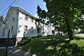
Smith Alumnae Gymnasium (Northampton)
This gymnasium on the Smith College campus in Northampton is a historic building. It's part of the rich history of this famous women's college.
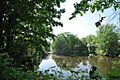
South Hadley Canal Historic District
This district along the historic canal route near the Connecticut River in South Hadley is very important. Canals were like early highways, helping transport goods and people.
South Worthington Historic District
This district spans parts of Worthington and Chesterfield, including Ireland Street, Conwell Road, Huntington Road, Thrasher Hill Road, Higgins Road, and South Worthington Road. It shows the historic rural character of the area.
Southampton Center Historic District
This district in Southampton includes High Street, College Highway, and East Street. It's the historic center of Southampton.
The Town Farm (Easthampton)
The Town Farm at 75 Oliver Street in Easthampton has a unique history. Town farms often served as places for the poor or elderly in earlier times.
Upper Main Street Historic District (Hatfield)
This district in Hatfield includes Main Street, King Street, and North Street. It's a historic residential and commercial area.
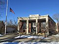
US Post Office-Easthampton Main
The US Post Office at 19 Union Street in Easthampton is a historic building. Many old post offices have interesting architecture.
US Post Office-South Hadley Main
The US Post Office at 1 Hadley Street in South Hadley is also a historic building.
Walker-Collis House (Belchertown)
The Walker-Collis House at 1 Stadler Street in Belchertown is a historic home.
Ware Center Historic District
This district in Ware includes Massachusetts Route 9 and Greenwich Plains Road. It's the historic center of Ware.
Ware Millyard Historic District
This district in Ware is roughly bounded by South Street, the Ware River, Upper Dam Complex, Park Street, Otis Avenue, and Church Street. It's a large historic industrial area centered around the mills.
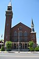
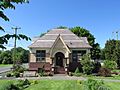
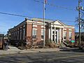
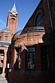
Ware Town Hall
The Ware Town Hall at Main and West Streets is a historic building that has served as the center of local government for many years.
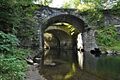
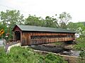
Ware-Hardwick Covered Bridge
This covered bridge on Old Gilbertville Road and Bridge Street in Ware is a beautiful and historic structure. Covered bridges are rare and special.
West Chesterfield Historic District
This district in Chesterfield includes Ireland Street, Main Road, and Cummington Road. It's a historic village area.
West Hatfield Historic District
This district in Hatfield includes Church Avenue, Linseed Road, and West Street. It's a historic neighborhood.
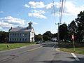
Williamsburg Center Historic District
This district in Williamsburg is along Massachusetts Route 9. It's the historic center of Williamsburg.
Woodbridge Street Historic District (South Hadley)
This district in South Hadley includes Silver Street and Woodbridge Street. It's a historic residential area.
Images for kids
-
Amherst Central Business District
-
Amherst West Cemetery
-
Baird House
-
Belchertown Center Historic District
-
Belchertown State School
-
Bisbee Mill
-
Bradstreet Historic District
-
William Cullen Bryant Homestead
-
Building at 8-22 Graves Avenue
-
Center Cemetery (Southampton)
-
Center Cemetery (Worthington)
-
Chesterfield Center Historic District
-
Church Street Historic District (Ware)
-
Conkey-Stevens House
-
Calvin Coolidge House
-
Cushman Village Historic District
-
Dickinson Historic District
-
Emily Dickinson Museum
-
Dorsey-Jones House
-
East Village Historic District (Amherst)
-
Elm Street Historic District (Hatfield)
-
Fort Hill Historic District (Northampton)
-
Gate Cemetery
-
Goodwin Memorial African Methodist Episcopal Zion Church
-
Grove Hill Mansion
-
Hadley Center Historic District
-
Hatfield Center Historic District
-
Haydenville Historic District
-
Hockanum Rural Historic District
-
Huntington Village Historic District
-
Ireland Street Cemetery
-
Lincoln-Sunset Historic District
-
Lockville Historic District
-
Main Street Historic District (Easthampton)
-
The Manse (Northampton)
-
Middlefield-Becket Stone Arch Railroad Bridge District
-
Middlefield Center Historic District
-
Mill-Prospect Street Historic District
-
Miss Florence Diner
-
Mountain Rest
-
Nashawannuck Mills Historic District
-
North Amherst Center Historic District
-
North Cemetery
-
North Hadley Historic District
-
North Hatfield Historic District
-
Northampton Downtown Historic District
-
Northampton State Hospital
-
Northampton Veterans Administration Hospital Historic District
-

Old Chapel (Amherst, Massachusetts)
-
Old Mill Site Historic District
-
Otis Company Mill No. 1
-
Parsons, Shepherd, and Damon Houses Historic District
-
Pelham Town Hall Historic District
-
Plainfield Center Historic District
-
Porter-Phelps-Huntington House
-
Prospect-Gaylord Historic District
-
Ringville Cemetery
-
Ross Farm
-
Smith Alumnae Gymnasium
-
South Amherst Common Historic District
-
South Hadley Canal Historic District
-
South Worthington Historic District
-
Southampton Center Historic District
-
Strong House
-
The Town Farm
-
Upper Main Street Historic District
-
US Post Office-Easthampton Main
-
US Post Office-South Hadley Main
-
Walker-Collis House
-
Ware Center Historic District
-
Ware Millyard Historic District
-
Ware Town Hall
-
Ware-Hardwick Covered Bridge
-
West Chesterfield Historic District
-
West Hatfield Historic District
-
Westside Historic District (Amherst)
-
Williamsburg Center Historic District
-
Woodbridge Street Historic District


_map.jpg)


