
National Register of Historic Places listings in Franklin County, Kansas facts for kids

This article is about the cool and historic places in Franklin County, Kansas, that are listed on the National Register of Historic Places. Think of it like a special list of buildings, bridges, and areas that are super important to history in the county.
These places are officially recognized by the United States government because they tell important stories about the past. There are 20 of these special spots in Franklin County.
Contents
Discovering Franklin County's Historic Treasures
Franklin County is home to many amazing places that are part of the National Register of Historic Places. These sites include old cabins, important buildings, and even bridges! Each one has a unique story that helps us understand what life was like long ago.
Historic Buildings and Homes
Many of the listed places are buildings that have stood for a long time. They show us how people lived, worked, and built things in the past.
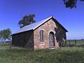
The Dietrich Cabin: A Pioneer Home
- Dietrich Cabin (listed 1972-02-23)
* Located in Ottawa City Park. * This cabin was built in 1859 by a German immigrant. It replaced his first cabin, which was sadly destroyed in a prairie fire. Imagine living in a cabin built almost 165 years ago! It shows us how tough and resourceful early settlers were.
Important Buildings in Ottawa
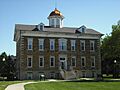
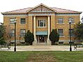
- Franklin County Courthouse (listed 1972-03-17)
* Found on Main Street in Ottawa. * This building is where important decisions for the county have been made for many years. Courthouses are often grand buildings that show the importance of local government.
- Tauy Jones Hall (listed 1982-06-14)
* On the Ottawa University campus in Ottawa. * This hall is part of a university, which means it has been a place of learning for many generations of students.
- Tauy Jones House (listed 1972-06-19)
* About 3 miles northeast of Ottawa, near Tauy Creek. * This house is another historic home, giving us a peek into the lives of important people from the past.
- Old Santa Fe Railroad Depot (listed 1973-03-01)
* Located at 135 W. Tecumseh Street in Ottawa. * This old train station was once a busy hub where people traveled and goods were shipped. It's now a museum, helping us remember the days of train travel.
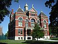
- Ottawa High School and Junior High School (listed 2000-10-06)
* Found at 526 and 506 S. Main Street in Ottawa. * These school buildings have seen thousands of students learn and grow over the years. They are important parts of the community's history.
- Ottawa Library (listed 1980-12-01)
* At 5th and Main Streets in Ottawa. * Libraries are special places for learning and reading, and this historic building has served the community for a long time.
- James H. Ransom House (listed 1974-11-21)
* Located at 318 S. Locust Street in Ottawa. * Another historic home that tells a story about the people who shaped Ottawa.
- Lyman Reid House (listed 2017-01-11)
* Found at 306 Elm Street in Ottawa. * This is one of the more recently added historic homes to the list, showing that important history is still being recognized.
- Wellsville Bank Building (listed 1991-10-24)
* Located at 418 Main Street in Wellsville. * This was the first brick building in Wellsville, built in 1884. It was where the Wellsville Bank started, showing how important banks were for growing towns.
Other Notable Homes and Schools
- Judge James Hanway House (listed 2008-12-11)
* Found at 658 Virginia Road in Lane. * This house belonged to an important judge, giving us insight into the legal history of the area.
- Pleasant Valley School District Number 2 (listed 2004-02-26)
* Located at 2905 Thomas Road in Wellsville. * This old schoolhouse reminds us of how education was provided in rural areas many years ago.
Historic Districts: Whole Areas with Stories
Sometimes, it's not just one building that's historic, but a whole group of buildings that make up a special area. These are called historic districts.
- Downtown Ottawa Historic District (listed 1972-06-29)
* This district covers the east side of S. Main Street in Ottawa. * It includes many buildings that together show what the downtown area looked like and how it developed over time.
- Historic Ottawa Central Business District (listed 2008-02-07)
* This larger area in Ottawa is roughly bounded by the Marias des Cygnes River, S. 5th Street, Walnut Street, and Hickory Street. * It represents the heart of Ottawa's business and community life from many years ago.
Historic Bridges: Connecting the Past
Bridges are also important historic sites because they show us how people built ways to cross rivers and creeks, connecting communities.
- Eight Mile Creek Warren Truss Bridge (listed 2003-05-09)
* Located on Osborne Terrace, west of Main Street in Ottawa. * This type of bridge, called a Warren Truss, was a common and strong design used in the past.
- Middle Creek Tributary Bridge (listed 1985-07-02)
* About 5.8 miles west of Princeton. * Another example of early bridge building in the county.
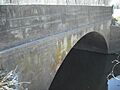
- Tauy Creek Bridge (listed 1990-10-25)
* Over Tauy Creek, north of Interstate 35 near Ottawa. * This bridge is close to the historic Tauy Jones House, showing how important these waterways were for travel.
- Walnut Creek Bridge (listed 1985-07-02)
* Off K-33, 1 mile south of Wellsville. * This bridge helped people cross Walnut Creek, making travel easier for farmers and residents.
Unique Historic Sites
Some places are special because they represent unique communities or ideas from the past.
- Silkville (listed 1972-12-15)
* About 2.5 miles southwest of Williamsburg on U.S. Route 50. * Silkville was a very unusual community founded in the 1870s by a French group who wanted to raise silkworms and produce silk in Kansas! It was an interesting experiment in farming and community living.
Images for kids
-
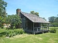
The historic Dietrich Cabin, built in 1859.
-

Buildings in the Downtown Ottawa Historic District.
-

The Eight Mile Creek Warren Truss Bridge.
-
The Franklin County Courthouse in Ottawa.
-
Tauy Jones Hall on the Ottawa University campus.
-
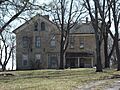
The historic Tauy Jones House.
-
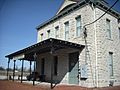
The Old Santa Fe Railroad Depot, now a museum.
-
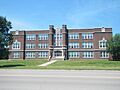
The historic Ottawa High School building.
-
The former Ottawa Library building.
-
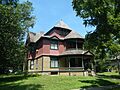
The James H. Ransom House.
-
The old schoolhouse at Silkville, a unique historic community.
-

The Tauy Creek Bridge.
-
The Walnut Creek Bridge near Wellsville.
-
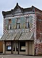
The Wellsville Bank Building, Wellsville's first brick building.


.JPG)
.JPG)
.JPG)


