
National Register of Historic Places listings in Graves County, Kentucky facts for kids

Have you ever wondered about old buildings and places that tell a story about the past? In Graves County, Kentucky, there are many special spots that are officially recognized for their history! These places are listed on the National Register of Historic Places. This is like a special list kept by the United States government to help protect important buildings, sites, and objects.
When a place is on this list, it means it's a valuable part of history. It could be an old house, a church, a cemetery, or even a whole downtown area! Protecting these places helps us learn about how people lived long ago and what was important to them. Graves County has 11 different places on this list, each with its own unique story. Let's explore some of them!
Contents
Historic Places in Graves County
Memorials and Cemeteries
Graves County is home to several memorials and cemeteries that remember important events and people, especially from the American Civil War.
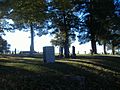
Camp Beauregard Memorial
- Location: Near Water Valley, Kentucky
- Listed: July 17, 1997
This memorial is found in the Camp Beauregard Cemetery. It remembers a training camp used during the Civil War. Soldiers from the Confederate army trained here. It's a quiet place to reflect on a difficult time in American history.
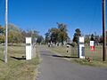
Confederate Memorial Gates in Mayfield
- Location: Maplewood Cemetery, Mayfield, Kentucky
- Listed: July 17, 1997
These gates stand at the entrance to Maplewood Cemetery. They were put there to honor Confederate soldiers. Cemeteries often have beautiful gates and monuments that tell us about the people buried there and the times they lived in.
Confederate Memorial in Mayfield
- Location: Mayfield, Kentucky
- Listed: July 17, 1997
Another memorial in Mayfield also honors Confederate soldiers. It's a reminder of the Civil War's impact on the area and the people who lived there.
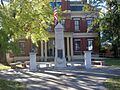
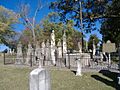
Wooldridge Monuments
- Location: Maplewood Cemetery, Mayfield, Kentucky
- Listed: August 11, 1980
These are some of the most unusual monuments you'll ever see! Colonel Henry G. Wooldridge created these monuments for himself and his family, including his beloved pets. The statues are very detailed and show different parts of his life. It's a unique way to remember someone and their loved ones.
Important Buildings and Districts
Many buildings in Graves County are special because of their architecture or their role in the community's development.
Pete Lyles House
- Location: Symsonia, Kentucky
- Listed: December 26, 2006
This house is a great example of an old home in the area. It shows us how people built and lived in homes many years ago.
Mayfield Downtown Commercial District
- Location: Mayfield, Kentucky
- Listed: August 16, 1984
This isn't just one building; it's a whole area! The Downtown Commercial District in Mayfield includes many historic shops and businesses. These buildings show how the town grew and became a center for trade and community life. Walking through this district is like taking a step back in time to see what Mayfield looked like decades ago.
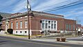
Mayfield Electric and Water Systems
- Location: Mayfield, Kentucky
- Listed: August 18, 2011
This building is important because it represents the history of how Mayfield got its electricity and water. These systems were vital for the town's growth and for making life easier for its residents.
Meacham Manor
- Location: East of Fulton, Kentucky
- Listed: December 31, 1974
Meacham Manor is another historic home in Graves County. It's recognized for its architectural style and its connection to the area's past.
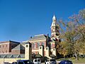
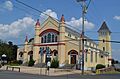
St. Jerome's Catholic Church Complex
- Location: Fancy Farm, Kentucky
- Listed: January 8, 2014
This complex includes the beautiful St. Jerome's Catholic Church and other buildings around it. Churches are often central to communities, and this one has a long history, serving the people of Fancy Farm for many years. Its architecture and long-standing role make it a significant historic site.
U.S. Post Office (Mayfield, Kentucky)
- Location: Mayfield, Kentucky
- Listed: December 2, 1982
The post office is more than just a place to send mail. Historically, post offices were important community hubs. This building in Mayfield is recognized for its design and its role in connecting people through mail services for many years.
Archaeological Sites
Some historic places aren't buildings at all, but sites where archaeologists can learn about ancient cultures.
Youngblood Site (15GV26)
- Location: Near Hicksville, Kentucky (Address is kept private to protect the site)
- Listed: April 4, 1986
This site is an archaeological treasure! It's a place where scientists can dig and find artifacts from people who lived in this area long, long ago. Because these sites are so fragile and important for research, their exact locations are often kept secret to protect them from damage.
These 11 places in Graves County are all special parts of Kentucky's history. They help us remember the past and understand how our communities grew and changed over time.
Images for kids
-
Camp Beauregard Memorial in Water Valley
-
Confederate Memorial Gates in Mayfield
-
Confederate Memorial in Mayfield
-

Pete Lyles House
-
Mayfield Downtown Commercial District
-

Mayfield Electric and Water Systems
-
St. Jerome's Catholic Church Complex
-
U.S. Post Office in Mayfield
-
Wooldridge Monuments


