
National Register of Historic Places listings in Hancock County, Mississippi facts for kids

Have you ever wondered about the oldest and most special buildings or places in your community? In Hancock County, Mississippi, there's a list of these amazing spots! It's called the National Register of Historic Places. This list helps protect and celebrate important places in the United States that tell us about history.
There are 18 places in Hancock County that are on this special list. One of them is even a National Historic Landmark, which means it's super important to the whole country! Some other places were once on the list but aren't anymore, often because they were damaged or destroyed.
Contents
Cool Places on the List Today
Let's explore some of the cool historic places you can find in Hancock County right now! These places are recognized for their history and unique features.
Historic Districts in Bay St. Louis
Many of the listed places are actually entire neighborhoods, called historic districts. These areas have lots of old buildings that together tell a story about the past.
- Beach Boulevard Historic District: This area in Bay St. Louis is along the beautiful Beach Boulevard. It includes many older homes and buildings that show how the town grew. It was added to the list in 1980.
- Main Street Historic District: Also in Bay St. Louis, this district covers Main Street. It's often the heart of a town, with historic shops and buildings. It was also listed in 1980.

- Old Bay St. Louis Historic District: This is a larger area that includes parts of the Beach Boulevard and Sycamore Street districts. It covers many old streets and shows the original layout of Bay St. Louis. It joined the list in 2010.
- Sycamore Street Historic District: Another historic street in Bay St. Louis, recognized in 1980 for its unique character.
- Washington Street Historic District: This district on Washington Street in Bay St. Louis was also recognized in 1980.
Special Buildings and Sites
Beyond whole neighborhoods, some individual buildings and even ancient sites are on the list.
- Building at 242 St. Charles Street: This specific building in Bay St. Louis was recognized in 1980. It's a great example of the architecture from its time.

- House at 5098 MS 604: Located in Pearlington, this house was added to the list more recently, in 2016. It's important for its history in that area.
- Waveland Elementary School: This old school building in Waveland was listed in 2014. Today, it's home to the Ground Zero Hurricane Museum, which teaches about hurricanes and their impact.

- Webb School/Gulf Coast Community Action Agency: This building in Bay St. Louis has served as both a school and a community agency. It was added to the list in 1986.

Ancient Sites and Mounds
Some of the oldest listings are not buildings at all, but archaeological sites! These are places where scientists find clues about people who lived long, long ago. Many of these sites have "Address Restricted" because they are fragile and need to be protected from damage.
- Claiborne Site (22Ha501): This site near Pearlington was listed in 1982. It's an important place for understanding ancient cultures in the area.
- Jackson Landing Site: Another ancient site near Pearlington, listed in 1973.
- Nugent Site (22HA592): This site near Kiln was added in 1988.
- SJ Mound (22HA594): A mound site near Pearlington, listed in 1988. Mounds were often built by ancient people for ceremonies or burials.
- Three Sisters Shell Midden (22-Ha-596): This site near Pearlington, listed in 1988, is a "shell midden." This means it's a pile of shells left behind by ancient people who ate shellfish. It tells us about their diet and lifestyle.
- Up the Tree Shell Midden (22HA595): Another shell midden site near Pearlington, listed in 1988.
- Williams Site (22-Ha-585): This ancient site near Pearlington was listed in 1988.
A National Historic Landmark: Rocket Propulsion Test Complex
One of the most exciting and important places on the list is the Rocket Propulsion Test Complex. This isn't just a local landmark; it's a National Historic Landmark!
- Rocket Propulsion Test Complex: Located at the National Space Technology Laboratories (now called Stennis Space Center) near Bay St. Louis, this complex was listed in 1985. This is where huge rocket engines for space missions, like the ones used for the Apollo moon landings and the Space Shuttle, were tested! It's a place where amazing science and engineering happened.

Places No Longer on the List
Sometimes, historic places are removed from the National Register. This often happens if they are destroyed or damaged beyond repair. Hancock County has unfortunately seen several historic places lost, especially due to powerful hurricanes.
- Glen Oaks: Also known as the Kimbrough House, this beautiful home on South Beach Boulevard in Bay St. Louis was listed in 1986. Sadly, it was completely destroyed by Hurricane Katrina in 2005 and removed from the list in 2008.
- Onward Oaks: Another home on South Beach Boulevard, listed in 1996. It was badly damaged by Hurricane Camille in 1969 and then completely destroyed by Hurricane Katrina in 2005. It was removed from the list in 2008.
- Taylor House: This house on North Beach Boulevard in Bay St. Louis was listed in 1986. Like many others, it was destroyed by Hurricane Katrina in 2005 and delisted in 2008.
- Taylor School: Located on Leonard Street in Bay St. Louis, this school was listed in 1987. It also fell victim to Hurricane Katrina in 2005 and was removed from the list in 2008.
These former listings remind us how important it is to protect our historic places, especially in areas prone to natural disasters.
Images for kids
-
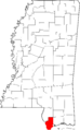
Location of Hancock County in Mississippi
-
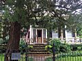
The historic building at 242 St. Charles Street.
-
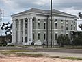
The Hancock County Courthouse, part of the Main Street Historic District.
-

A Saturn V rocket stage being tested at the Rocket Propulsion Test Complex.
-
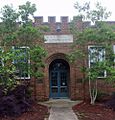
Waveland Elementary School, now a museum.
-

The historic Webb School building.
