
National Register of Historic Places listings in Hopkins County, Kentucky facts for kids

Have you ever wondered about the old buildings and special places in your town or county? Many of these places are super important because they tell us stories about the past! In the United States, there's a special list called the National Register of Historic Places. It's like a hall of fame for buildings, sites, and objects that are important to American history, architecture, archaeology, engineering, or culture. When a place is on this list, it means it's worth protecting and preserving for future generations.
This article is all about the amazing historic places right here in Hopkins County, Kentucky. There are 32 different properties and areas in our county that are on this important list. One place was on the list before but has since been removed. Let's explore some of these cool historical spots!
Contents
Historic Sites in Hopkins County
Hopkins County is full of interesting places that have been recognized for their historical value. These sites include old homes, schools, and even entire neighborhoods! Each one has a unique story to tell about the people and events that shaped our community.
Important Homes and Buildings
Many of the places on the National Register are old houses or public buildings. They show us how people lived and worked many years ago.
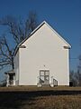
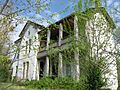
- Beulah Lodge in Dawson Springs: This historic lodge was added to the list in 1989.
- John Cox House near Nebo: A historic home listed in 1988.
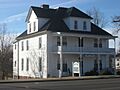
- The Darby House in Dawson Springs: This house, located on West Arcadia Avenue, joined the list in 1997.
- Bazle Edmiston House near Nebo: Another historic home added in 1988.
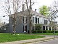
- Dr. Thomas Gardiner House in Madisonville: This house on Sugg Street was listed in 1988.
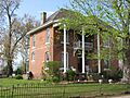
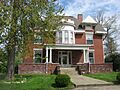
- John Harvey House in Madisonville: Located on N. Seminary Street, this house was designed by a famous architect named George Franklin Barber and listed in 1988.
- L.D. Hockersmith House in Madisonville: This home on S. Scott Street was added in 1988.
- Hotel Earlington in Earlington: A historic hotel on E. Main Street, listed in 1988.
- Beckley Jackson House near Hanson: This house was added to the list in 1989.
- Gabriel Jennings House near Dawson Springs: Listed in 1988.
- W.W. Kington House in Mortons Gap: This house on Crooked Street was listed in 1988.
- Chittenden P. Lyon, Jr. House in Madisonville: An older listing from 1976, located on Union Street.
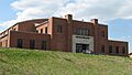
- Madisonville Armory in Madisonville: This building on Park Avenue was listed in 2002.
- Madisonville Public Library in Madisonville: The former library building on S. Union Street was listed in 1988.
- Madisonville Tuberculosis Hospital in Madisonville: This hospital on Hospital Drive was added to the list more recently, in 2016.
- Frederick Miller House near White Plains: Listed in 1988.
- Oakmoor in Earlington: This historic site on E. Main Street was listed in 1988.
- Bradford Porter House near Nebo: Listed in 1988.
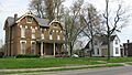
- Turner Ruby House in Madisonville: This home on S. Union Street was added in 1988.
- Richard Salmon House near Dawson Springs: Listed in 1988.
- James E. Slaton House in Madisonville: Listed in 1988.
- US Post Office-Madisonville in Madisonville: The post office on N. Main Street was listed in 1989.
- Zion Brick Missionary Church near Hanson: This church was added to the list in 1988.
Historic Districts and Other Places
Sometimes, a whole area or neighborhood is important enough to be listed as a "historic district." This means many buildings in that area contribute to its historical significance.
- Archeological Site 15 HK 46 and 47 near White Plains: These are ancient sites that tell us about people who lived here long, long ago. They were listed in 1980.
- Archeological Site 15 HK 79 near Nebo: Another important ancient site, listed in 1980.
- Archeological Site 15 HK 8 near Hanson: This archaeological site was listed in 1980.
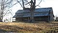
- Cranor School near St. Charles: This old school building was listed in 1989.
- Dawson Springs Historic District in Dawson Springs: This district includes parts of S. Main Street and other nearby streets. It was listed in 1988, with more streets added later.
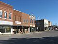
- Hanson Historic District in Hanson: This district covers parts of Main Street and E. Railroad Street, listed in 1988.
- Madisonville Commercial Historic District in Madisonville: This important area around Center and Main Streets was listed in 1988.
- Munn's School in Madisonville: This old school on Princeton Road was listed in 1983.
- North Main Street Historic District in Madisonville: This district includes the 200 and 300 blocks of N. Main Street and was listed in 1988.
Former Listing
Sometimes, a place that was once on the National Register of Historic Places might be removed. This can happen if the building is changed too much, or if it is unfortunately destroyed.
- Hamby Well Building in Dawson Springs: This building on S. Main Street was listed in 1972 but was removed from the list in 1988.
Images for kids
-
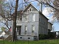
Beulah Lodge
-
The Darby House
-
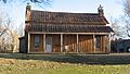
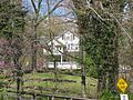
Part of the Dawson Springs Historic District
-
Bazle Edmiston House
-
Dr. Thomas Gardiner House
-
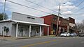
A street view in the Hanson Historic District
-
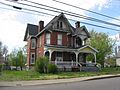
John Harvey House
-
L.D. Hockersmith House
-
Hotel Earlington
-
Gabriel Jennings House
-
W.W. Kington House
-
Chittenden P. Lyon, Jr. House
-
Madisonville Armory
-
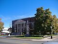
The Hopkins County Courthouse, part of the Madisonville Commercial Historic District
-
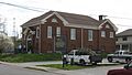
The former Madisonville Public Library
-
A street in the North Main Street Historic District
-
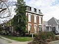
Oakmoor
-
Turner Ruby House
-
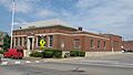
The US Post Office in Madisonville


