
National Register of Historic Places listings in Jasper County, Missouri facts for kids

Have you ever wondered about old buildings and places that are super important to history? In Jasper County, Missouri, there are many special spots that are listed on the National Register of Historic Places. This is like a special list kept by the United States government to protect places that tell us about the past. These places could be old homes, schools, theaters, or even entire neighborhoods!
When a place is on this list, it means it's recognized for its history, amazing architecture, or how it helped shape the community. It also means people will work to keep it safe and preserved for future generations, like you! There are 40 different properties and areas in Jasper County that have earned this special recognition. Let's explore some of them!
Fun Historic Places in Jasper County
The Cool 66 Drive-In
Imagine watching a movie under the stars! The 66 Drive-In in Carthage, Missouri is a classic drive-in movie theater. It's located right on the famous Route 66, which was a very important highway for travel across America. This drive-in opened way back in 1949 and is still showing movies today! It's a great example of how people used to enjoy entertainment.

Carthage's Historic Downtown
The heart of Carthage, Missouri is its Carthage Courthouse Square Historic District. This area includes the beautiful old Jasper County Courthouse and many other buildings around it. These buildings show off different styles of architecture from the late 1800s and early 1900s. It's a place where you can really feel the history of the town.
The Jasper County Courthouse
The Jasper County Courthouse itself is a grand building. It was built in 1894 and has a tall clock tower. This courthouse is where important decisions for the county have been made for over a hundred years. It's a symbol of the community's history and government.


Historic Homes and Neighborhoods
Many old houses and neighborhoods in Jasper County are also on the National Register. These places give us a peek into how people lived long ago.
The Lucius P. Buchanan House
The Lucius P. Buchanan House in Joplin, Missouri is a beautiful old home. It was built in 1913 and is a great example of the "Prairie Style" of architecture, which was popular at the time. Today, this house is part of Missouri Southern State University and is used as the Ralph L. Gray Alumni Center.
The Phelps Country Estate
Out in the countryside near Carthage, Missouri, you'll find the Phelps Country Estate. This large property includes a historic house and other buildings. It shows what a grand country home looked like in the late 1800s and early 1900s.
Important Buildings in Joplin
Joplin, Missouri has many historic buildings, especially downtown. These buildings tell the story of Joplin's growth as a mining and business center.
The Fox Theater
The Fox Theater in Joplin is a beautiful old movie palace. It opened in 1930 and was a fancy place where people went to watch films and enjoy live shows. The theater has amazing decorations inside and out, showing the style of that time.

The Joplin Carnegie Library
Libraries are super important, and the Joplin Carnegie Library is a historic one. It was built in 1903 with money from Andrew Carnegie, a famous businessman who helped build many libraries across the country. It's a place where generations of Joplin residents have gone to learn and read.

The Joplin Union Depot
Train stations were once busy hubs of travel and trade. The Joplin Union Depot was Joplin's main train station. Built in 1910, it was a grand building where people arrived and departed, and goods were shipped. It played a big role in connecting Joplin to other cities.

The Scottish Rite Cathedral
The Scottish Rite Cathedral in Joplin is a large and impressive building. It was built in 1923 and is known for its unique architecture. It's a meeting place for a group called the Scottish Rite of Freemasonry and is a significant landmark in the city.

Webb City's Historic Spots
Webb City, Missouri also has its share of historic places.
The Middle West Hotel
The Middle West Hotel in Webb City was once a busy hotel for travelers and business people. Built in 1911, it shows the kind of places people stayed when they visited the town.

The Elijah Thomas Webb House
The Elijah Thomas Webb House is a significant home in Webb City. Elijah Thomas Webb was one of the founders of Webb City, so his house is an important part of the town's history. It was built around 1881 and gives us a look at the early days of the city.

Images for kids
-
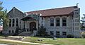
A historic library in Webb City, part of the Downtown Webb City Historic District.
-

Buildings in the Cassill Place Historic District in Carthage.
-
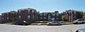
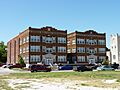
The Colonial Apartments in Carthage.
-
The Elks Club Lodge No. 501 building in Joplin.
-
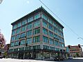
The Gentry Apartments in Joplin.
-
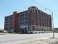
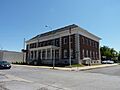
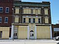
The Inter-State Grocer Company Building in Joplin.
-
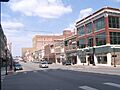
A street view of the Joplin Downtown Historic District.
-
The Joplin Supply Company building.
-
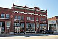
Buildings in the Main and Eighth Streets Historic District in Joplin.
-
The Newman Brothers Building in Joplin.
-
The Olivia Apartments building in Joplin.
-
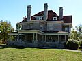
The main house at the Phelps Country Estate.
-
The Rains Brothers Building in Joplin (destroyed by fire in 2012).
-
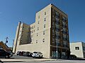
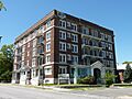
The Ridgway Apartments in Joplin.
-
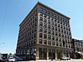
The St. Louis and San Francisco Railroad Building in Joplin.
-
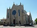
St. Peter the Apostle Catholic Church and Rectory in Joplin.
-
Buildings in the South Main Street Historic District in Joplin.


