
National Register of Historic Places listings in Jefferson County, Arkansas facts for kids

Have you ever heard of the National Register of Historic Places? It's like a special list of important buildings, places, and objects in the United States that are worth protecting because of their history. This list helps make sure these cool spots are preserved for future generations to learn from and enjoy.
This article shares some of the amazing places in Jefferson County, Arkansas that are on this list. These spots tell stories about the county's past, from old homes and churches to unique roads and even trains! There are 73 places in Jefferson County currently on the National Register. Some others were once listed but have since been removed.
Contents
What is the National Register of Historic Places?
The National Register of Historic Places is the official list of the nation's historic places worth saving. It's managed by the National Park Service, which is part of the U.S. government. When a place is added to this list, it means it's important to American history, architecture, archaeology, engineering, or culture.
Being on the list can help protect these places and sometimes even provide money to help fix them up. It's a way to celebrate and remember the past, making sure these special sites are around for a long, long time.
Historic Buildings and Homes
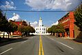
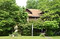
Jefferson County is home to many historic buildings, especially in Pine Bluff, Arkansas. These places show us what life was like long ago and how architecture has changed over time.
Cool Houses to Discover
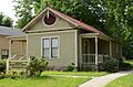
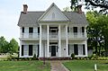
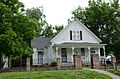
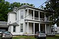
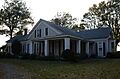
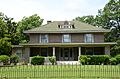
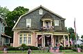
- R.M. Knox House: Located in Pine Bluff, this house was built in 1885. It's a great example of the Eastlake Victorian style, which is known for its fancy wooden decorations. It even has a three-story tower! R.M. Knox was a rich businessman in Pine Bluff who built this impressive home.
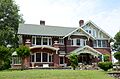
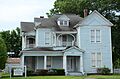
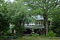
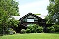
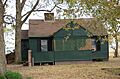
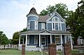
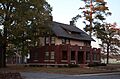
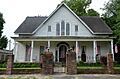
- Boone-Murphy House: Also in Pine Bluff, this house was added to the list in 1979. It's another beautiful example of older homes in the area.
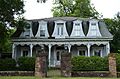
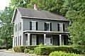
- Du Bocage: This historic home in Pine Bluff was listed in 1974. It's a grand old house that shows the style of homes built in the past.
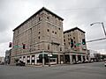
- Hotel Pines: This hotel in Pine Bluff was added to the list in 1979. Hotels like this were once very important places for travelers and community events.
- Masonic Temple: Found in Pine Bluff, this building was listed in 1978. Masonic Temples are often known for their unique and grand architecture.
- Merchants and Planters Bank Building: This old bank building in Pine Bluff, listed in 1978, shows us what banks looked like in earlier times.
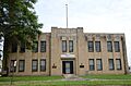
- National Guard Armory-Pine Bluff: This building, listed in 2001, served as a training and storage facility for the National Guard. It's an important part of military history in the area.
- Pine Bluff Civic Center: Listed in 2005, this building is a key part of the city's public life and architecture.
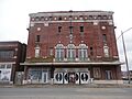
- Saenger Theater: This theater in Pine Bluff, listed in 1995, was a popular spot for movies and shows. Old theaters often have amazing designs inside.
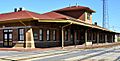
- Union Station: This train station in Pine Bluff, listed in 1978, was a busy hub for travel and trade. Train stations are often beautiful buildings that saw many people come and go.
Churches and Cemeteries with History
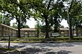
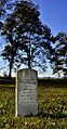
- Antioch Missionary Baptist Church Cemetery: This cemetery in Sherrill, Arkansas, listed in 2010, is a quiet place that holds the history of many people from the community.
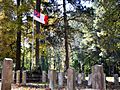
- Camp White Sulphur Springs Confederate Cemetery: Located near Sulphur Springs, this cemetery, listed in 2005, is a historic burial ground.
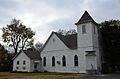
- Lone Star Baptist Church: This church in Redfield, Arkansas, listed in 2005, is an important part of the community's spiritual and social history.
- Sherrill Methodist Episcopal Church, South: This church in Sherrill, listed in 2002, is another example of the historic places of worship in the county.
- St. Peter's Cemetery: Located south of New Gascony, this cemetery, listed in 1998, is a significant historic site.
- Trinity Episcopal Church: This church in Pine Bluff, listed in 1974, is a beautiful example of historic church architecture.
- Wabbaseka Methodist Episcopal Church, South: This church in Wabbaseka, Arkansas, listed in 2002, is an important historic building in its community.
Unique Historic Sites
Not all historic places are buildings! Some are roads, monuments, or even old trains.
Roads and Bridges
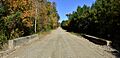
- Dollarway Road: This historic road, partly in Redfield, was listed in 1974. It's one of the oldest paved roads in Arkansas and was a big deal when it was built!
- West James Street Overpass: This overpass in Redfield, listed in 1995, is a historic bridge that crosses over train tracks. It's part of a group of important old bridges in Arkansas.
Monuments and Public Art
- Pine Bluff Confederate Monument: This monument, located at the Jefferson County Courthouse in Pine Bluff, was listed in 1996. It's a statue that remembers a part of history.
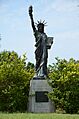
- Strengthen the Arm of Liberty Monument-Pine Bluff: This monument in Pine Bluff, listed in 2000, is a smaller version of the Statue of Liberty. It was given to communities across the U.S. by the Boy Scouts of America.
Historic Trains and Railroad Items
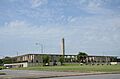
The Arkansas Railroad Museum in Pine Bluff is home to several historic trains and railroad items that are on the National Register. These show us how important trains were for travel and moving goods long ago.
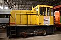
- Central Texas Gravel Locomotive No. 210: This old train engine, listed in 2007, is a piece of railroad history.
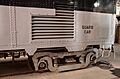
- DODX Guard Car No. G-56: This special railroad car, listed in 2007, was used to guard important cargo.
- St. Louis San Francisco (Frisco) Railway Coach No. 661: This passenger car, listed in 2006, once carried people on train journeys.
- St. Louis Southwestern Railway (Cotton Belt Route) Caboose No. 2325: This caboose, listed in 2006, was the last car on a freight train.
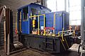
- St. Louis Southwestern Railway (Cotton Belt Route) Relief Train: This entire train, listed in 2007, was used to help out when there were problems on the tracks.
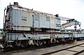
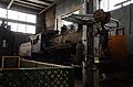
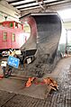
- St. Louis Southwestern Railway (Cotton Belt Route) Steam Locomotive No. 336: This powerful steam engine, listed in 2007, is a classic example of old trains.
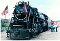
- St. Louis Southwestern Railway Steam Locomotive No. 819: Another famous steam engine, listed in 2003, this locomotive is a big part of Arkansas's railroad heritage.
- United States Army Snow Plow No. SN-87: This unique snow plow, listed in 2007, was used by the army to clear tracks.
- Wabash Alloys Locomotive: This locomotive, listed in 2007, is another example of the different types of engines used on the rails.
Other Interesting Places
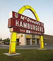
- McDonald's Store #433 Sign: This sign in Pine Bluff, listed in 2006, is special because it's an old, classic McDonald's sign from 1962. It shows how fast food restaurants used to look!
- Taylor Field: This field in Pine Bluff, listed in 2010, is important because it was part of the "New Deal" efforts during the Great Depression, which helped put people back to work.
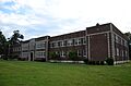
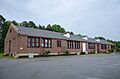
- Tucker School: This school in Tucker, Arkansas, listed in 2005, is a historic building that served the community's children for many years.
- John Brown Watson Memorial Library Building: This library building in Pine Bluff, listed in 2006, is an important place for learning and reading in the community.
Historic Districts
Sometimes, a whole area or group of buildings is important enough to be listed together. These are called historic districts.
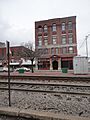
- Pine Bluff Commercial Historic District: This area in Pine Bluff, listed in 2008, includes many old shops and businesses that show what the city's downtown looked like.
- Pine Bluff Fifth Avenue Historic District: This district in Pine Bluff, listed in 1980, is a neighborhood with many historic homes.
- Plum Bayou Homesteads: Located north of Pine Bluff, this area, listed in 1975, includes historic farms and homes that tell the story of how people settled and lived off the land.
- Redfield School Historic District: This district in Redfield, listed in 2014, includes the historic school building and surrounding area.
Images for kids
-
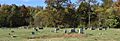
Antioch Missionary Baptist Church Cemetery
-
Arkansas Louisiana Gas Company Building
-
Jewel Bain House Number 2
-
Bellingrath House
-
Boone-Murphy House
-
Caldwell Hall
-
Camp White Sulphur Springs Confederate Cemetery
-
Carnahan House
-
Central Texas Gravel Locomotive No. 210
-
Community Theatre
-
DODX Guard Car No. G-56
-
Dollarway Road
-
Du Bocage
-
Ferguson House
-
Fox House
-
Gibson-Burnham House
-
Hotel Pines
-
Howson House
-
Hudson House
-
Hudson-Grace-Borreson House
-
Johnson House
-
Katzenstein House
-

R.M. Knox House
-
Lake Dick
-
R.E. Lee House
-
Lone Star Baptist Church
-
MacMillan-Dilley House
-
Masonic Temple
-
McDonald's Store #433 Sign
-

Merchants and Planters Bank Building
-
Mills House
-
National Guard Armory-Pine Bluff
-
Nichol House
-
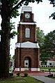
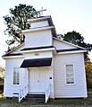
W.E. O'Bryant Bell Tower
-
Parkview Apartments
-
Pine Bluff Civic Center
-
Pine Bluff Commercial Historic District
-

Pine Bluff Confederate Monument
-
Pine Bluff Fifth Avenue Historic District
-
Plum Bayou Homesteads
-
Prigmore House
-
Puddephatt House
-
Redfield School Historic District
-
Roselawn
-
Roth-Rosenzweig House
-
Saenger Theater
-
St. Louis Southwestern Railway (Cotton Belt Route) Relief Train
-
St. Louis Southwestern Railway (Cotton Belt Route) Steam Locomotive #336
-
St. Louis Southwestern Railway Steam Locomotive #819
-
St. Peter's Cemetery
-
Sherrill Methodist Episcopal Church, South
-
Walter B. Sorrells Cottage
-
Strengthen the Arm of Liberty Monument-Pine Bluff
-
Taylor Field
-
Temple House
-

Trinity Episcopal Church
-
Trulock-Cook House
-
Trulock-Gould-Mullis House
-
Tucker School
-
Union Station
-
United States Army Snow Plow #SN-87
-
Wabash Alloys Locomotive
-
Wabbaseka Methodist Episcopal Church, South
-

John Brown Watson Memorial Library Building
-
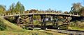
West James Street Overpass
-
Yauch-Ragar House


_before_1905_via_HS_Goodman%27s_Knox_Family.jpg)


_Relief_Train.jpg)
_Steam_Locomotive_336.jpg)


