Redfield, Arkansas facts for kids
Quick facts for kids
Redfield, Arkansas
|
|
|---|---|
| City of Redfield | |

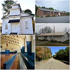
Clockwise from top: The Old Redfield School, Redfield City Hall, the Dollarway Road, Redfield Gymnasium, and the Lone Star Baptist Church
|
|

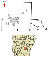
Location in Jefferson County and Arkansas
|
|
| Country | United States |
| State | |
| County | Jefferson |
| Township | Barraque |
| Founded | December 20, 1880 |
| Incorporated | October 18, 1898 |
| Founded by | James K. Brodie |
| Named for | Jared E. Redfield |
| Government | |
| • Type | Mayor–Council |
| Area | |
| • Total | 3.148 sq mi (8.15 km2) |
| • Land | 3.094 sq mi (8.01 km2) |
| • Water | 0.054 sq mi (0.14 km2) |
| Elevation | 302 ft (92 m) |
| Population
(2020)
|
|
| • Total | 1,505 |
| • Density | 486.43/sq mi (187.84/km2) |
| Time zone | UTC– 06:00 (CST) |
| • Summer (DST) | UTC– 05:00 (CDT) |
| ZIP code |
72132
|
| Area code | 501 |
| FIPS code | 05-58580 |
| GNIS feature ID | 58477, 2404603 |
| Highways | |
| Major airport | Clinton National Airport (LIT) |
For people with the surname, see Redfield (surname).
Redfield, officially called the City of Redfield, is a small city in Jefferson County, Arkansas, United States. It is about 24 miles (38.6 km) southeast of Little Rock. Redfield is part of the larger Pine Bluff area. In 2020, about 1,505 people lived there. Long ago, the land where Redfield now stands was home to the Quapaw Nation. James K. Brodie founded Redfield in 1880. It was named after Jared E. Redfield, who was the president of a railway company. Redfield has two special areas that protect old, important buildings and places.
Contents
History of Redfield
Redfield started as a small town when the Little Rock, Mississippi River and Texas Railway built a station there. This railway was also known as the "Arkansas Valley Route." The town was named after Jared E. Redfield, the railway company's president.
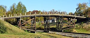
Redfield was founded on December 20, 1880. It officially became a city on October 18, 1898. Several places in Redfield are listed on the National Register of Historic Places (NRHP). This means they are important historical sites. These include the Dollarway Road (added in 1974), the West James Street Overpass (1995), and the Lone Star Baptist Church (2005). Also, the Redfield School Historic District (2014) and the Redfield Commercial Historic District (2023) are protected.
Geography of Redfield
Redfield covers a total area of about 3.148 square miles (8.15 square kilometers). Most of this area is land, about 3.094 square miles (8.01 square kilometers). A small part, about 0.37%, is water.
People and Population
A census is a count of how many people live in a place. The United States government does a census every ten years.
Population Changes Over Time
| Historical population | |||
|---|---|---|---|
| Census | Pop. | %± | |
| 1890 | 400 | — | |
| 1900 | 333 | −16.7% | |
| 1910 | 278 | −16.5% | |
| 1920 | 296 | 6.5% | |
| 1930 | 350 | 18.2% | |
| 1940 | 339 | −3.1% | |
| 1950 | 291 | −14.2% | |
| 1960 | 242 | −16.8% | |
| 1970 | 277 | 14.5% | |
| 1980 | 745 | 169.0% | |
| 1990 | 1,082 | 45.2% | |
| 2000 | 1,157 | 6.9% | |
| 2010 | 1,297 | 12.1% | |
| 2020 | 1,505 | 16.0% | |
| U.S. Decennial Census | |||
The population of Redfield has changed over the years. In 1890, there were 400 people. By 2020, the population had grown to 1,505 people.
What the 2020 Census Shows
In 2020, there were 1,505 people living in Redfield. These people lived in 640 different homes, and 428 of these were families.
| Race | Number of People | Percentage |
|---|---|---|
| White (not Hispanic) | 1,163 | 77.28% |
| Black or African American (not Hispanic) | 213 | 14.15% |
| Native American | 5 | 0.33% |
| Asian | 13 | 0.86% |
| Pacific Islander | 3 | 0.2% |
| Other/Mixed | 64 | 4.25% |
| Hispanic or Latino | 44 | 2.92% |
What the 2010 Census Shows
In 2010, Redfield had 1,297 people living there. There were 525 homes. About 29.9% of homes had children under 18. Many homes (52.2%) were married couples. The average age of people in Redfield was 38.5 years.
Arts and Culture
The Pine Bluff and Jefferson County Library System runs the public library in Redfield. The library building is about 5,500 square feet (511 square meters) in size. It first opened its doors in 1999.
Education in Redfield
Public schools in this part of Jefferson County are managed by the White Hall School District. This school district has two high schools and four elementary schools. One of the elementary schools, M. A. Hardin Elementary School, is located right in Redfield.
Transportation and Roads
Redfield is connected by several important roads. Arkansas Highway 365 links Redfield to Pine Bluff and Little Rock. Arkansas Highway 46 connects Redfield to Sheridan. The city is also near Interstate 530, which can be reached using Highway 46.
See also
 In Spanish: Redfield (Arkansas) para niños
 | Sharif Bey |
 | Hale Woodruff |
 | Richmond Barthé |
 | Purvis Young |


