
National Register of Historic Places listings in Kane County, Utah facts for kids

Have you ever wondered about the oldest and most special places in your community? In Kane County, Utah, there are many amazing spots that are so important, they've been added to a special list called the National Register of Historic Places. This list helps protect buildings, sites, and objects that are important to American history, architecture, archaeology, engineering, or culture.
When a place is on this list, it means it's recognized as a valuable part of our past. It also helps make sure these places are preserved for future generations, like you! Kane County is home to 19 of these incredible historic sites, from old houses and schools to ancient cliff dwellings and famous natural landmarks. Let's explore some of them!
Contents
Exploring Kane County's Historic Treasures
Kane County is full of history, from ancient times to more recent pioneer days. The places on the National Register of Historic Places tell many stories about the people who lived here and the events that shaped the area.
Historic Homes and Buildings
Many of the places on the list are old homes and buildings that show us what life was like long ago.
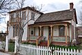
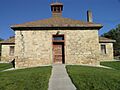
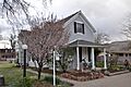
Bowman-Chamberlain House
The Bowman-Chamberlain House is located in Kanab. It was built a long time ago and is a great example of the kind of homes people lived in during the early days of the county. It helps us imagine how families lived and grew in this area.
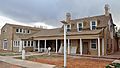
William Derby Johnson, Jr., House
Also in Kanab, the William Derby Johnson, Jr., House is another historic home. It's a beautiful building that has been well-preserved. Today, it even serves as a bed and breakfast, so people can stay in a piece of history!
Rider-Pugh House
The Rider-Pugh House, also in Kanab, is another example of the historic homes that dot the landscape of Kane County. These houses are important because they show us the different styles of building and living from the past.
Stewart-Woolley House
The Stewart-Woolley House is yet another historic home in Kanab. Together, these houses give us a glimpse into the daily lives of the early settlers and how their communities grew.
Kanab Lodge
The Kanab Lodge, sometimes called the Union Pacific Lodge, is a significant building in Kanab. It was once a busy place, perhaps welcoming travelers or serving as a community hub. Buildings like this show how important lodges and hotels were in connecting towns and people.
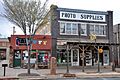
Kanab Hotel and Cafe
The Kanab Hotel and Cafe is another important historic spot in Kanab. Hotels and cafes were vital places where people could eat, rest, and gather. They were often the heart of social life in small towns.
Kanab Library
The Kanab Library is a special building that has served the community for many years. Libraries are important centers for learning and sharing knowledge, and this historic building has played a big role in the education of Kanab's residents.
Kanab Post Office
The Kanab Post Office is where letters and packages have been sent and received for a long time. Post offices are essential for connecting people, and this building represents a key part of how communities communicate.
Parry Lodge
The Parry Lodge in Kanab is another historic lodge that has welcomed many guests over the years. It's known for its connection to the early film industry, as many movie stars stayed there when filming Westerns in the area.
Valley School
In Orderville, the Valley School is a historic school building. Schools are incredibly important because they are where generations of children have learned and grown. This building reminds us of the value of education in the community's past.
Ancient and Natural Wonders
Kane County is also home to incredible ancient sites and natural landmarks that tell stories from thousands of years ago.
Cottonwood Canyon Cliff Dwelling
The Cottonwood Canyon Cliff Dwelling is an ancient site where early people lived in homes built into the cliffs. These dwellings give us clues about how ancient civilizations survived and thrived in this rugged landscape.
Davis Gulch Pictograph Panel
The Davis Gulch Pictograph Panel features ancient rock art, or pictographs. These drawings on rock walls were made by early inhabitants and can tell us about their beliefs, daily lives, and the animals they saw. It's like a history book written on stone!
Hole-In-The-Rock
The Hole-In-The-Rock is a famous natural rock formation. It's a huge crack in the cliff that was used by pioneers as a difficult but important route to cross the land. It's a symbol of the challenges and determination of early settlers.
Hole-in-the-Rock Trail
The Hole-in-the-Rock Trail is the path that pioneers took, starting near Escalante and going all the way to Bluff. This trail is incredibly important because it shows the incredible effort and bravery of those who traveled across Utah's tough terrain.
Other Unique Historic Sites
Some places on the list are unique and don't fit neatly into other categories, but they are just as important.
Maynard and Edith Hamlin Dixon House and Studio
Near Mt. Carmel Junction, you'll find the Maynard and Edith Hamlin Dixon House and Studio. Maynard Dixon was a famous American artist known for his paintings of the American West. This was his home and where he created many of his beautiful artworks. It's a special place for art lovers and history buffs alike.
Mt. Carmel School and Church
The Mt. Carmel School and Church is a historic building that served both as a place of learning and worship for the community of Mt. Carmel Junction. It highlights how important both education and faith were to the early settlers.
Rainbow Point Comfort Station and Overlook Shelter
Inside Bryce Canyon National Park, the Rainbow Point Comfort Station and Overlook Shelter is a historic structure. It was built to help visitors enjoy the stunning views of the park. It shows how early parks were designed to welcome people and protect natural beauty.
Riggs Spring Fire Trail
Also in Bryce Canyon National Park, the Riggs Spring Fire Trail is a historic trail. It was likely used for managing forests and preventing fires. Trails like this are important for understanding how people have interacted with and managed natural landscapes over time.
Images for kids
-
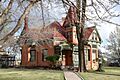
The historic Bowman-Chamberlain House in Kanab.
-

Image for Cottonwood Canyon Cliff Dwelling (address restricted).
-
Image for Davis Gulch Pictograph Panel (address restricted).
-
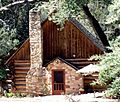
The Maynard and Edith Hamlin Dixon House and Studio.
-
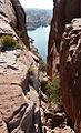
The famous Hole-In-The-Rock formation.
-
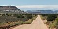
A view of the Hole-in-the-Rock Trail.
-
The William Derby Johnson, Jr., House.
-
The historic Kanab (Union Pacific) Lodge.
-
The Kanab Hotel and Cafe.
-
The Kanab Post Office building.
-
The Mt. Carmel School and Church.
-
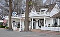
The Parry Lodge in Kanab.
-
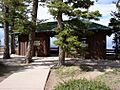
The Rainbow Point Comfort Station and Overlook Shelter in Bryce Canyon.
-
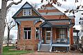
The Rider-Pugh House.
-
The Stewart-Woolley House.
.jpg)


.jpg)
.jpg)


.jpg)

.jpg)
.jpg)
