
National Register of Historic Places listings in Limestone County, Alabama facts for kids

Have you ever wondered about the old buildings and special places in your town or county? Many of these places have amazing stories to tell! In Limestone County, Alabama, there are several historic sites and districts that are so important, they've been added to a special list called the National Register of Historic Places.
This list is like a hall of fame for historic places across the United States. When a place is added, it means it's recognized for its unique history, architecture, or its role in important events. It helps protect these places for future generations to enjoy and learn from. Limestone County is proud to have 13 such places on this list!
What is the National Register of Historic Places?
The National Register of Historic Places (often called the NRHP) is the official list of the nation's historic places worth saving. It's part of a program run by the National Park Service. This program helps people understand and appreciate America's rich history.
When a building, a group of buildings, or even a whole neighborhood is listed, it means it has special meaning. It could be important because of its age, its design, or because famous people lived there or important events happened there. Being on the list encourages people to take care of these places.
Historic Places in Limestone County
Limestone County is full of history, and many of its special places are on the National Register. Let's explore some of them!
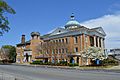
Athens Courthouse Square Commercial Historic District

The heart of Athens beats around its historic courthouse square. This area, known as the Athens Courthouse Square Commercial Historic District, was added to the National Register on October 10, 1997. It includes many old buildings that once housed shops and businesses. Imagine what it was like to shop here many years ago! The district is roughly bounded by Clinton, Hobbs, Madison, and Green Streets.
Athens State University Historic District

Athens State University has a beautiful campus with a lot of history. The Athens State College Historic District was recognized on February 14, 1985. It includes several historic buildings on the central campus, roughly bordered by Beaty, Pryor, and Hobbs Streets. These buildings have seen many students come and go, learning and growing over the years.
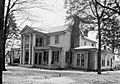
Belle Mina Plantation

The historic home called Belle Mina is located south of Belle Mina on the Mooresville-Elkton Road. It was added to the National Register on October 31, 1972. This old plantation house offers a glimpse into the past, showing how people lived and worked in Alabama many years ago.
Robert Donnell House

The Robert Donnell House, located at 601 S. Clinton Street in Athens, is another important historic home. It was listed on September 19, 1973. This house is a great example of the architecture from its time and tells a story about the people who lived there.
George S. Houston Historic District

Named after a former governor of Alabama, the George S. Houston Historic District in Athens is a large area with many historic homes and buildings. It was added to the National Register on July 20, 1989. This district includes parts of 2nd Avenue, Jefferson Street, McClellan Street, Marion Street, Hobbs Street, Madison Street, Washington Street, and Houston Street. Walking through this area is like stepping back in time!
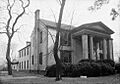
Governor George Smith Houston House
.jpg)
The home of Governor George Smith Houston, located at 101 N. Houston Street in Athens, is a significant individual listing. It was added to the National Register on May 15, 1986. Governor Houston was an important figure in Alabama's history, and his home is a reminder of his legacy.
Mooresville Historic District

Mooresville is a very special place, so much so that the entire town is a historic district! It was listed on April 13, 1972. Located off Interstate 565, Mooresville is one of Alabama's oldest incorporated towns. It has many well-preserved buildings from the 19th century, making it feel like a living museum.
Old Athens Main Post Office

The building that once served as the main post office for Athens, located at 310 W. Washington Street, is also on the National Register. It was listed on February 18, 1982. This building played an important role in the community's daily life for many years.
Robert Beaty Historic District

Another historic neighborhood in Athens is the Robert Beaty Historic District, added on August 30, 1984. It's roughly bounded by the old Louisville and Nashville railroad line and Forrest, East, and Washington Streets. This district showcases a variety of historic homes and buildings that tell the story of Athens' growth.
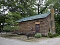
Sulphur Trestle Fort Site

Near Elkmont, about 1 mile south, is the Sulphur Trestle Fort Site. This site was added to the National Register on May 8, 1973, and its boundaries were even expanded on July 21, 2015. This location was important during the American Civil War, and the fort protected a vital railroad bridge. It's a place where you can imagine soldiers from long ago.
Other Notable Listings
- Blackburn House: Located west of Athens, this house was listed on September 20, 1984.
- Cotton Hill: Found at 23789 Huntsville-Brownsferry Road E. in Athens, Cotton Hill was added on December 10, 2014.
- Woodside: Southwest of Belle Mina, Woodside was listed on February 19, 1982.
Former Listings
Sometimes, a place might be removed from the National Register. This can happen if a building is destroyed or if its historical features are changed too much. In Limestone County, one place that was once listed was:
- Cave Place: Located near Mooresville, this site was listed on February 19, 1982, but was later delisted on December 7, 1989.
These historic places in Limestone County are like open books, each telling a part of Alabama's amazing story. They remind us of the past and help us understand how our communities came to be.
Images for kids
-
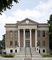
The Limestone County Courthouse, part of the Historic District
-
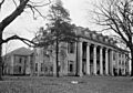
Founders Hall at Athens State University
-
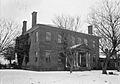
Belle Mina, a historic home in Limestone County
-
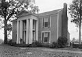
The historic Robert Donnell House
-
Athens First Methodist Church, within the George S. Houston Historic District
-
The Governor George Smith Houston House
-
The historic post office in Mooresville
-
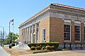
The Old Athens Main Post Office building
-
The Beaty-Mason House, part of the Robert Beaty Historic District
-

The site of the Sulphur Trestle Fort
