
National Register of Historic Places listings in Malheur County, Oregon facts for kids
The National Register of Historic Places is like a special list of important buildings, places, and areas in the United States. These places are chosen because they have a lot of history or are very special in some way. They could be old houses, famous landmarks, or even entire neighborhoods! When a place is on this list, it means people want to help protect it so future generations can learn from and enjoy it.
Malheur County in Oregon has many amazing places on this list. They tell stories about the people who lived here long ago, how they built their homes, worked, and traveled. Let's explore some of these cool historic spots!
Contents
- Exploring Old Buildings
- The Birch Creek Ranch
- The Blackaby House
- The First Bank of Vale
- The Green Lantern Saloon
- The Moses and Mary Hart Stone House
- The Hotel Western
- The Old Stone House in Vale
- The Oregon Short Line Railroad Depot
- The Pelota Fronton
- The Sheep Ranch Fortified House
- Al Thompson and Son's Feed and Seed Company
- The Vale Drug Store
- The Vale Hotel and Grand Opera House
- The Vale Independent Order of Odd Fellows Hall
- The Vinsonhaler Blacksmith Shop
- Important Historic Areas
- See also
- External links
Exploring Old Buildings
Many of the historic places in Malheur County are interesting old buildings. They show us what life was like in the past.
The Birch Creek Ranch
The Birch Creek Ranch Historic Rural Landscape is a large area that includes an old ranch. It's located where the Owyhee River meets Birch Creek. This ranch shows us how people lived and worked on farms and ranches a long time ago in this part of Oregon. It was added to the list on August 25, 1997.

The Blackaby House
The James Rowley and Mary J. Blackaby House is a historic home in Ontario, Oregon. It's located at 717 SW 2nd Street. This house is a great example of the kind of homes people built in the early 1900s. It was added to the National Register on December 28, 2001.
.jpg)
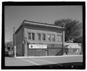
The First Bank of Vale
The First Bank of Vale is an old bank building at 148 Main Street South in Vale. Imagine how different banks were back then! This building was an important part of the town's business and history. It joined the list on March 5, 1992.

The Green Lantern Saloon
The Green Lantern Saloon is a historic building in Nyssa, Oregon, at 11 South 1st Street. Saloons were popular gathering places in the past. This building gives us a peek into the social life of the community long ago. It was listed on September 6, 1996.

The Moses and Mary Hart Stone House
The Moses and Mary Hart Stone House and Ranch Complex is a unique stone house and ranch located about one mile west of the Post Office on Bully Creek County Road in Westfall. Building with stone was a common way to make strong, lasting homes. This complex was added to the list on October 1, 2001.

The Hotel Western
The Hotel Western is an old hotel building at 9 Good Avenue in Nyssa. Hotels were very important for travelers and new settlers coming to the area. This building tells us about the early days of travel and hospitality in Nyssa. It was listed on September 6, 1996.

The Old Stone House in Vale
The Old Stone House in Vale, located at 283 Main Street South, is another example of early stone construction. This building has seen many changes in Vale over the years. It was added to the National Register on May 19, 1972.
_(malD0081).jpg)
The Oregon Short Line Railroad Depot
The Oregon Short Line Railroad Depot is an old train station at 300 Depot Lane in Ontario. Train stations were busy places where people traveled and goods were shipped. This depot reminds us of the important role railroads played in connecting communities. It was listed on August 5, 1999.

The Pelota Fronton
The Pelota Fronton is a special court for playing a game called pelota, located on Bassett Street (U.S. 95) in Jordan Valley. This unique building shows the cultural heritage of the Basque people who settled in this area and brought their traditions with them. It was added to the list on May 19, 1972.
_(malDA0101).jpg)
The Sheep Ranch Fortified House
The Sheep Ranch Fortified House is a historic building near Arock, at 3192 Old I-O-N Highway. A "fortified" house means it was built to be very strong, perhaps for protection. This house gives us clues about what life was like for early settlers in more remote areas. It was listed on November 1, 1974.

Al Thompson and Son's Feed and Seed Company
The Al Thompson and Son's Feed and Seed Company building is at 117 Good Avenue in Nyssa. This kind of business was vital for farmers, providing supplies for their crops and animals. It shows us the agricultural roots of the area. It was listed on September 6, 1996.

The Vale Drug Store
The Vale Drug Store is an old pharmacy building at 158 Main Street North in Vale. Drug stores were important community hubs, providing medicines and other goods. This building helps us imagine what shopping was like long ago. It was added to the list on September 6, 2002.

The Vale Hotel and Grand Opera House
The Vale Hotel and Grand Opera House at 123 Main Street South in Vale was a grand place! It served as both a hotel and a theater for performances. Imagine people staying here and watching shows. It was listed on August 1, 1984.

The Vale Independent Order of Odd Fellows Hall
The Vale Independent Order of Odd Fellows Hall is located at 122 Main Street South in Vale. The Independent Order of Odd Fellows was a fraternal organization, like a club, that helped people in the community. Their hall was a place for meetings and social events. It was listed on December 6, 2016.
The Vinsonhaler Blacksmith Shop
The Vinsonhaler Blacksmith Shop is at 122 Good Avenue in Nyssa. A blacksmith was a very important person in early towns, making and repairing metal tools, horseshoes, and other items. This shop reminds us of the skilled trades that were essential for daily life. It was listed on September 6, 1996.

Important Historic Areas
Sometimes, not just one building, but a whole area is important because of its history. These are called Historic Districts.
The Oregon Trail Historic District
The Oregon Trail Historic District near Vale is a special area about five miles southeast of Vale at Lytle Boulevard. This district includes parts of the famous Oregon Trail, where pioneers traveled west in wagons. You can still see the ruts left by their wagons! It was listed on October 29, 1975.

The Owyhee Dam Historic District
The Owyhee Dam Historic District is located near Adrian, on Owyhee Lake Road. This district includes the Owyhee Dam, which was a huge engineering project when it was built. Dams are important for controlling water and providing power. This district was added to the list on September 23, 2010.
_(malD0117a).jpg)
See also
- National Register of Historic Places listings in Oregon
- Listings in neighboring counties: Baker, Canyon, Grant, Harney, Humboldt, Owyhee, Payette, Washington
- Historic preservation
- History of Oregon
- Lists of Oregon-related topics
External links
- Oregon Parks and Recreation Department, National Register Program
- National Park Service, National Register of Historic Places site
