History of Oregon facts for kids

The history of Oregon covers five main periods. These include the very old geologic history, how native peoples lived there, early visits by Europeans (mostly fur traders), when pioneers settled the land, and how Oregon developed into modern times.
The name "Oregon" can mean a few things:
- Oregon Country: A large area explored by Americans and the British. Canadians often called it the Columbia District.
- Oregon Territory: This was set up by the United States after the Oregon Treaty gave them control of the area.
- Oregon: The U.S. state since 1859.
Historians have not studied the history of Oregon and the Pacific Northwest as much as other parts of the American West.
Contents
Oregon's Ancient Past: Geology and Land Formation
Volcanoes helped shape Oregon's land starting about 40 million years ago. During the last ice age, about 2 million to 700,000 years ago, the Columbia River carved its way through the Cascade Range. This created the amazing Columbia River Gorge.
The Columbia River and its surrounding area saw some of the biggest floods ever known. These happened at the end of the last ice age. Huge ice dams at Glacial Lake Missoula would break. This sent water rushing out at ten times the speed of all the world's rivers combined! This happened up to forty times over a thousand years.
During these Missoula Floods, water levels were incredibly high. They reached 1,250 feet (381 m) at the Wallula Gap in Washington. Water was 830 feet (253 m) deep at Bonneville Dam. It was even 400 feet (122 m) deep over today's Portland, Oregon. These floods left behind rich soil, which is why the area is so good for farming today. They also formed strange land features, like the channeled scablands in eastern Washington.
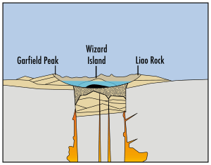
Mount Mazama was once the tallest mountain in the region, about 11,000 feet high. Around 5677 B.C., it had a massive volcanic eruption. This eruption was 42 times stronger than the 1980 eruption of Mount St. Helens. The top of Mount Mazama collapsed into its empty magma chamber. This created the deep hole that now holds Crater Lake in southern Oregon. The entire mountain is now part of Crater Lake National Park.
The Klamath Native Americans believed the mountain was home to Llao, their god of the underworld. When the mountain exploded, the Klamaths told stories of a great battle between Llao and Skell, their sky god.
In 1700, a huge earthquake hit the Cascadia subduction zone off the Pacific Northwest coast. This earthquake caused a tsunami that reached Japan. It might also be linked to the Bonneville Slide. In this event, a large part of Washington's Table Mountain fell into the Columbia River Gorge. This blocked the river and formed the Bridge of the Gods. Local Native American stories remember this land bridge.
Celilo Falls, a series of rapids on the Columbia River, was a vital fishing spot for native peoples for thousands of years. People from all over the Pacific Northwest came to Celilo Village to trade. In 1957, the rapids were covered by water when The Dalles Dam was built.
In 1980, Mount St. Helens in nearby Washington erupted violently. This temporarily made the Columbia River as shallow as 13 feet. It also hurt Portland's economy. Ash from the eruption fell as far into Oregon as Bend.
Oregon's First People: Native Americans
Ancient Inhabitants: Paleo-Indians
There is strong evidence that very early people, called Paleo-Indians, lived in the Pacific Northwest 15,000 years ago. The first proof of human life in Oregon came in 1938. Archaeologist Luther Cressman found sage bark sandals near Fort Rock Cave. These showed people lived in Oregon as early as 13,200 years ago. Cressman found more signs of early humans at Paisley Caves. Researchers from the University of Oregon have found new evidence there recently. By 8000 B.C., settlements were all over the state. Most were along the lower Columbia River, in western valleys, and near coastal rivers.
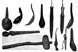
By the 1500s, many Native American groups lived in Oregon. These included the Bannock, Chasta, Chinook, Kalapuya, Klamath, Molalla, Nez Perce, Takelma, and Umpqua.
Native peoples generally welcomed Europeans in the 1800s. They saw new chances for trade. However, new diseases brought by Europeans were very harmful to local populations. Later, Americans wanted to use the natural resources of the West, especially along the Columbia River. This caused problems with native groups. Many tribes accepted money from the U.S. government. In return, they gave up their traditional fishing spots and moved to reservations.
Since the late 1900s, building casinos on reservations has helped some tribes earn money. State laws do not apply on reservations. During Governor Ted Kulongoski's time, the Warm Springs Indians worked to build a casino outside their reservation in the Columbia River Gorge.
Early European Explorers in Oregon
How early European explorers saw Oregon depended on why and how they explored. Official explorers first came by sea, often looking for the Northwest Passage. Later, they came by land. But they missed many parts of what is now Oregon. Fur traders and trappers, especially from the Hudson's Bay Company, explored the land more deeply. They wrote about meeting most of the local Native American tribes. Christian missionaries and later settlers sent exciting reports back home.
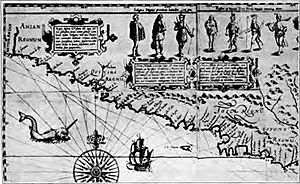
A Spanish exploration team led by Juan Rodríguez Cabrillo saw the southern Oregon coast in 1543. In 1592, Juan de Fuca made detailed maps and studied ocean currents. Their trips included Oregon and the strait named after him. Exploration started again regularly in 1774. The frigate Santiago, led by Juan José Pérez Hernández, began these trips. Soon, the Oregon coast became an important trade route to Asia.
Spanish explorers found a way to explore the Pacific coast as early as 1565. They sent ships northeast from the Philippines. These ships rode the Kuroshio Current in a big circle across the northern Pacific. These 250 ships, over many years, usually did not land before reaching Cape Mendocino in California. But some landed or crashed in what is now Oregon. Nehalem Indian stories tell of strangers and finding things like beeswax chunks and a silver vase. These likely came from the 1707 wreck of the San Francisco Xavier.
Juan Pérez explored the Pacific Northwest coast north to British Columbia in 1774. He was the first European to see Yaquina Head on the Oregon Coast. In 1775, another Spanish group, led by Juan Francisco de la Bodega y Quadra and Bruno de Heceta, explored the coast. On his way back south, Heceta found the mouth of the Columbia River, but could not enter it.
British explorer James Cook explored the Oregon Coast in 1778. He was looking for the Northwest Passage. Starting in the late 1780s, many ships from Britain, America, and other countries sailed to the Pacific Northwest. They came for the growing fur trade. American sea captain Robert Gray entered the Columbia River in 1792. Soon after, a ship led by George Vancouver, a British captain, also explored Puget Sound and claimed it for Britain.
The Lewis and Clark Expedition traveled through the region. They were exploring the Louisiana Purchase. They built their winter fort at Fort Clatsop, near the mouth of the Columbia River. The explorations by Lewis and Clark (1805–1806) and Britain's David Thompson (who explored the Columbia River from 1807–1811) showed how many fur-bearing animals were in the area.
Oregon's Border Dispute
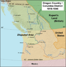
Both Britain and the U.S. claimed Oregon. At first, the disagreement was friendly. But it grew into a threat of war before it was settled peacefully in 1846. The region was split 50-50.
After the Anglo American Treaty of 1818, the U.S. and Britain "jointly occupied" the region. Americans called it Oregon Country. The British called it the Hudson's Bay Company's Columbia District. This area was managed from Fort Vancouver near today's Vancouver, Washington.
In the 1820s and early 1830s, American trappers explored the West. They formed fur trading companies from St. Louis. One such trapper was Jedediah Smith. He led trips into the American West. On October 29, 1830, Smith sent a letter and map to John H. Eaton, the Secretary of War. It had information from his explorations of the Rockies, the South Pass, and the Pacific Northwest. Smith suggested that President Jackson end the 1818 Treaty. This treaty gave the British free use of the Columbia River. Smith also reported that Native Americans preferred the British.
British fur companies tried to stop Americans. They created a "fur desert" along the eastern and southern borders. They trapped all the animals so there was nothing left for the Americans.
The balance of power changed in the 1830s. Thousands of American settlers arrived. They soon controlled the southern half of the disputed region. Joint occupation ended with the Oregon Treaty in 1846. Britain and the U.S. split the region equally along today's borders. The U.S. generally received lands south of the 49th parallel. The Oregon Territory was officially formed in 1848.
Pioneers Settle Oregon
The Astor Expedition (1810–1812) was funded by American businessman John Jacob Astor. It brought fur traders to the future site of Astoria by both land and sea. Fort Astoria was the first permanent white settlement in the region. Even though the fort was under American control for only a short time, it helped the United States claim the region later. A group returning east found the South Pass through the Rocky Mountains. This became a very important part of the Oregon Trail.
During the War of 1812, Fort Astoria was at risk of being captured by the British. So, in October 1813, Fort Astoria and all other Pacific Fur Company properties in Oregon Country were sold to the Montreal-based North West Company. The North West Company had already been expanding into the Pacific Northwest. They controlled the region without challenge from 1813 until 1821. Then, they joined with the Hudson's Bay Company. During this time, the North West Company used Astor's plan. They sent supplies by sea to the Columbia River and shipped furs directly to China. The Hudson's Bay Company expanded this system. In the 1820s and 1830s, they controlled the Pacific Northwest from their headquarters at Fort Vancouver. This fort was built in 1825 by John McLoughlin, the Chief Factor, across the Columbia from today's Portland. Even though fewer furs and lower prices hurt the company in the early 1840s, it remained important until the Oregon Treaty of 1846.
In the 1830s, several American groups traveled to Oregon. They helped establish the Oregon Trail. Many of these travelers were missionaries who wanted to teach Christianity to native peoples. Jason Lee was the first. He traveled with Nathaniel Jarvis Wyeth in 1833. Lee set up the Oregon Mission in the Willamette Valley. The Whitmans and Spaldings arrived in 1836. They established the Whitman Mission east of the Cascades. In 1839, the Peoria Party left Illinois for Oregon.
In 1841, a rich trapper named Ewing Young died without a will. There was no system to handle his property. So, people suggested forming a government at a meeting after Young's funeral. Doctor Ira Babcock from Jason Lee's Methodist Mission was chosen as Supreme Judge. Babcock led two meetings in 1842 at Champoeg. This town was halfway between Lee's mission and Oregon City. They discussed issues like wolves and other concerns. These meetings led to a larger meeting in 1843. This meeting created a provisional government. It was led by an executive committee of David Hill, Alanson Beers, and Joseph Gale. This was the first working public government of the Oregon Country before the U.S. officially took control.
The Oregon Trail brought many new settlers to the region. This started in 1842–1843. This was after the United States agreed to jointly settle the Oregon Country with the United Kingdom. For a while, it seemed the U.S. and the U.K. might go to war again. But the border was peacefully set in 1846 by the Oregon Treaty. The border between the U.S. and British North America was set at the 49th parallel. The Oregon Territory was officially organized in 1848.
Many efforts were made to find easier land routes to the Willamette Valley starting in the 1840s. The Barlow Road, Meek Cutoff, and Applegate Trail were attempts to cross the Cascades in northern, central, and southern Oregon. The Barlow Road became the last part of the Oregon Trail after it was built in 1846. The Santiam Wagon Road cut through the central mountains, succeeding where Meek had failed.
More people settled in Oregon because of the Donation Land Claim Act of 1850. This law, along with the forced movement of native people to Indian reservations, encouraged settlement. Oregon became a U.S. state on February 14, 1859.
Oregon During the Civil War
When the American Civil War began, regular U.S. troops left Oregon and went east. Volunteer soldiers were recruited in California and sent north to Oregon. Their job was to keep peace and protect the people. Oregon also formed the 1st Oregon Cavalry. This group started in 1862 and served until June 1865. During the Civil War, settlers continued to have conflicts with the Paiute, Shoshone, and Bannock tribes in Oregon, Idaho, and Nevada. These conflicts grew into the bloody Snake War from 1864 to 1868. The 1st Oregon Volunteer Infantry Regiment was formed in 1864. Its last company finished service in July 1867. Both groups guarded travel routes and Indian reservations. They also escorted immigrant wagon trains and protected settlers from Indian attacks. Some infantry groups also went with survey teams and built roads in central and southern Oregon.
Oregon Senator Colonel Edward Dickinson Baker was killed leading Union troops at the Battle of Ball's Bluff on October 21, 1861.
Railroads and Oregon's Growth
In the 1880s, more railroads helped sell the state's lumber and wheat. They also helped cities grow faster. Railroads connected Oregon to the Eastern United States. This allowed goods and people to move more quickly. More people moved to Oregon after these connections were made. Other transportation improvements included building several locks and canals to make river travel easier.
Also in the 1880s, writer Frances Fuller Victor published stories and histories. She based them on her deep research of the region's past. She also interviewed many Oregon pioneers. Her most famous non-fiction works, which covered many western states, were written for Hubert Howe Bancroft's History Company. At the time, they were published under his name. Her writing was said to truly capture the idea of Manifest Destiny during this time of American expansion.
Oregon's Modern History
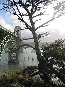
Industrial growth really took off after the Bonneville Dam was built from 1933 to 1937 on the Columbia River. The power, food, and lumber from Oregon helped the West develop. However, ups and downs in the nation's building industry have sometimes hurt Oregon's economy.
Oregon has a long history of strong disagreements. These include Native Americans versus British fur trappers, British versus U.S. settlers, ranchers versus farmers, and rich growing cities versus older, poorer rural areas. There have also been conflicts between loggers and environmentalists, and between different political groups. Oregonians also have a long history of wanting to form new states or even countries from parts of Oregon.
In 1902, Oregon approved a system where citizens could directly make laws. This was through initiative and referendum, known as the Oregon System. In 1908, citizens also gained the power to remove public officials by voting. Oregon's ballots often include both politically conservative ideas, like anti-gay and pro-religious measures, and politically liberal issues, like drug decriminalization. This shows the wide range of political ideas in the state.
 | Victor J. Glover |
 | Yvonne Cagle |
 | Jeanette Epps |
 | Bernard A. Harris Jr. |


