
Wallula Gap facts for kids
Quick facts for kids Wallula Gap |
|
|---|---|

View of Wallula Gap from Wallula, Washington Main Street
|
|
| Lua error in Module:Location_map at line 420: attempt to index field 'wikibase' (a nil value). | |
| Location | Columbia River Basin, Washington state |
| Designated | 1980 |

The Wallula Gap is a huge opening where the Columbia River cuts through the Horse Heaven Hills. These hills are made of basalt rock that has folded up. You can find the Wallula Gap in the Columbia River Basin in Washington state. It's just south of where the Walla Walla and Columbia rivers meet.
This special place has been named a National Natural Landmark by the National Park Service. This means it's a very important spot for understanding the Earth's history in the United States.
Contents
How Was Wallula Gap Formed?
Giant Lava Flows
Imagine a time when huge amounts of super-hot, runny lava flowed out of cracks in the ground! This happened in southeastern Washington, eastern Oregon, and southern Idaho. These lava flows spread out far and wide, creating vast, gently sloped fields of rock.
Along the Snake River in Idaho and the Columbia River in Washington and Oregon, you can still see these ancient lava flows. They are almost 2 kilometers (1.24 miles) thick in some places! The lava flows you see at Wallula Gap formed about 17 million years ago. They are part of a massive group of lava flows called the Columbia River Basalt Group.
The Land Begins to Fold
As the lava was erupting, the land in the southern and western parts of the Columbia Plateau started to bend and fold. This included the area where Wallula Gap is now. If you look closely at the steep walls of the gap, you can clearly see the bent and folded layers of ancient lava rock.
Rivers Carve the Gap
When the land first started to fold, there was a low spot along the ridge at Wallula Gap. An ancient river, called the Salmon-Clearwater River, began to flow over this low spot. It started to cut a channel through the rock. Even as the ridge continued to fold upwards, the river kept eroding the rock, creating the water gap we see today.
For a long time, about 10 million years ago, only the Salmon-Clearwater River flowed through Wallula Gap. But then, the land in the Columbia Basin tilted, pushing the Columbia River eastward. About 6 million years ago, the Columbia River joined the Salmon-Clearwater River. Later, about 2.5 million years ago, the Snake River was also pushed north by the rising Blue Mountains. It then joined the Salmon-Clearwater River near the Idaho-Oregon border.
The Massive Missoula Floods
About 14,000 years ago, the Wallula Gap became even wider because of some incredible events! Huge amounts of water from the Salmon, Snake, and Columbia rivers, combined with melting glacial water, poured across the land during what are known as the Missoula floods.
The Wallula Gap was like a narrow funnel for these floods. Less than one-fifth of the enormous amount of water entering the area each day could pass through it. Because of this, the floods filled up the Pasco Basin and created a temporary lake called Lake Lewis. The huge amount of water rushing through the gap helped carve out its steep walls. You can still see features like "Twin Sisters" that were shaped by these floods.
During the Missoula floods, water piled up in the Pasco Basin because the Wallula Gap was too narrow to let it all through quickly. Even though the gap is 2 kilometers (1.2 miles) wide, the floods were so massive that they couldn't drain fast enough. The water reached heights of about 380 meters (1,247 feet)! The force of the water pushing through the gap was incredible, and the peak flow is estimated to have been about 10 million cubic meters (353 million cubic feet) of water per second.
History of Wallula Gap
Lewis and Clark's Visit
The famous Lewis and Clark Expedition first saw the Wallula Gap on October 18, 1805. They were traveling downstream from their camp where the Columbia and Snake rivers meet. The group camped nearby that night and then traveled through Wallula Gap the next day.
A Stop on the Oregon Trail
In the 1840s, pioneers heading west on the Oregon Trail found Wallula Gap to be a good stopping point. It was a logical place for them to change their wagons into boats. From there, they would continue their journey by floating down the Columbia River.
Legends of the Gap
The Twin Sisters Story

"Twin Sisters" is a tall rock pillar made of basalt. It inspired a cool legend about the Wallula Gap. This legend comes from the Cayuse people, a Native American tribe who lived on the Columbia Plateau.
Here's the story: Coyote, who is a clever trickster spirit in many Native American tales, fell in love with three sisters. These sisters were building a fish trap in the river nearby. Every night, Coyote would sneak out and destroy their trap. But every day, the girls would rebuild it!
One morning, Coyote saw the girls crying. They told him they were starving because they couldn't catch any fish. Coyote promised them a working fish trap if they would agree to become his wives. The sisters agreed, and Coyote kept his promise. However, as years passed, he became jealous of them. So, he used his magic to turn two of the wives into these basalt pillars you see today. He turned the third sister into a cave further downstream. Coyote then turned himself into a rock nearby so he could watch over them forever.
This spot is a popular place for hikers. They love to explore the unique geology of the Wallula Gap and see the amazing effects of the ancient Missoula Floods.
Images for kids
-
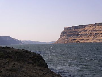
View from the northern end toward the south within the Walulla Gap
-
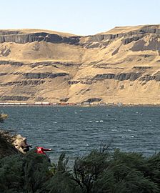
View to the west across the Walulla Gap


See also
 In Spanish: Brecha de Wallula para niños
