
Lake Lewis facts for kids
Quick facts for kids Lake Lewis |
|
|---|---|

This picture shows Lake Lewis at different flood levels. It helps us see how the lake filled up several valleys where special rock layers called Touchet Beds were found.
|
|

Lake Lewis
Location in Washington (state)

Lake Lewis
Location in the United States
|
|
| Location | North America |
| Coordinates | 46°10′N 119°00′W / 46.167°N 119.000°W |
| Lake type | former lake |
| Primary inflows | Channeled Scablands |
| Primary outflows | Wallula Gap of the Columbia River |
| Basin countries | United States |
| Max. length | 105 mi (169 km) |
| Max. width | 130 mi (210 km) |
| Max. depth | 320 ft (98 m) |
| Residence time | 20 incidents |
| Surface elevation | 1,200 ft (366 m) |
Lake Lewis was a huge, temporary lake that once covered parts of the Pacific Northwest in North America. It formed around 14,000 years ago. This giant lake appeared because of massive floods known as the Missoula Floods.
These floods happened when water from Glacial Lake Missoula and other ancient lakes suddenly burst through ice dams. This created enormous waves of water. When these floodwaters reached a narrow spot called the Wallula Gap in southern Washington, they couldn't flow through fast enough. The water then backed up, forming Lake Lewis. The lake would stay for a few weeks before draining away through the Wallula Gap. At its highest, Lake Lewis reached about 1,200 feet (370 m) above today's sea level.
Lake Lewis also flooded into several river valleys, including the Yakima, Walla Walla, Touchet, and Tucannon valleys.
Contents
Discovering Lake Lewis: What Clues Did Scientists Find?
Scientists have found several clues that tell us about the existence of Lake Lewis and how it formed. These clues include the unique shape of the Wallula Gap, special layers of rock called Touchet Formation, and large rocks called glacial erratics.
The Wallula Gap: A Narrow Gateway

The Wallula Gap is a big, narrow passage carved through ancient rock layers in the Columbia River basin. It's located just south of where the Walla Walla River meets the Columbia River. This gap has been around for millions of years.
During the Missoula Floods, huge amounts of glacial water rushed across the Channeled Scablands. When this water hit the Wallula Gap, it could only squeeze through slowly. Less than one-fifth of the massive daily water flow could get through. This caused the water to back up, filling the area and creating Lake Lewis for a short time. The powerful floods also made the gap even wider and carved out unique features in the rock.
Touchet Formation: Layers of Lake Mud

When Lake Lewis backed up, it flooded into the Yakima, Walla Walla, Touchet, and Tucannon River Valleys. In these calmer parts of the lake, the water was thick with mud, sand, and tiny rocks. These materials had been picked up and carried by the powerful floods.
Over time, these suspended materials settled to the bottom of the lake. This created many distinct layers of sediment, which scientists call the Touchet Formation. You can find these thick layers throughout these valleys today, acting as a clear sign of the ancient lake.
Glacial Erratics: Rocks Carried by Ice

Another important clue comes from glacial erratics. These are large rocks that are different from the local bedrock. They were picked up by glaciers and carried far from their original locations. When the glaciers melted or broke apart during the floods, these rocks were dropped.
Scientists found these erratics on the slopes of the Horse Heaven Hills and other high areas in the mid-Columbia region. They were found at elevations up to 1,200 feet (370 m) above sea level. This matches the highest level Lake Lewis reached. It's like finding a rock from far away on top of a hill, showing how high the water must have been to carry it there.
During the floods, some long ridges, like the Saddle Mountains and Rattlesnake Mountain, stayed above the water. Peaks like Badger, Candy, and Red Mountains became islands in the vast Lake Lewis.
Images for kids
-
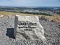
A trail marker on Badger Mountain showing the ancient Lake Lewis waterline.

