
National Register of Historic Places listings in Baker County, Oregon facts for kids
Baker County, Oregon, is home to many special places listed on the National Register of Historic Places. This list includes buildings, areas, and structures that are important to the history of the United States. These historic sites in Baker County tell us stories about how people lived, worked, and built communities long ago. They help us understand the past and protect these important places for the future.
Contents
Exploring Baker County's Historic Treasures
Buildings with Cool Stories
Baker County has several buildings that have played important roles in its history.
Antlers Guard Station
The Antlers Guard Station is a rustic cabin and garage located in the Wallowa–Whitman National Forest near Whitney. It was built around 1935 by the Civilian Conservation Corps (CCC). The CCC was a program during the Great Depression that gave jobs to young men. They helped build many things for the United States Forest Service, like this station. It shows how people worked together to build important structures and protect our forests.
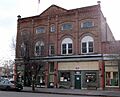
Baker Historic District
The Baker Historic District covers a large area along Main Street in Baker City. This district includes many old buildings that show what the town looked like in the past. Walking through this area is like stepping back in time, seeing the architecture and layout of a historic Oregon city.
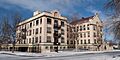
Baker Municipal Natatorium
The Baker Municipal Natatorium is an old public swimming pool building located at 2470 Grove Street in Baker City. Built in 1977, it was an important place for recreation and community gatherings.
Churchill School
The Churchill School at 3451 Broadway Street in Baker City is another historic building. Schools are often central to a community's history, and this one likely served many generations of students in Baker City.
Cornucopia Jailhouse
The Cornucopia Jailhouse on 2nd Street in Cornucopia is a small, unique building. Old jails tell us about law and order in early settlements, especially in mining towns like Cornucopia. It's a reminder of how communities managed justice in the past.
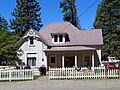
Old St. Elizabeth Hospital
The old St. Elizabeth Health Services building, also known as St. Elizabeth Hospital, is located at 2365 4th Street in Baker City. This building served as a hospital for many years, providing care to the people of Baker County. It represents the history of healthcare in the region.
Life on the Farm and in Town
Historic homes and commercial buildings also tell us about daily life.
James O. Maxwell Farmstead
The James O. Maxwell Farmstead is a historic farm located at 15177 Muddy Creek Lane near Haines. Farmsteads like this show us how families lived and worked the land, providing food and resources for their communities. It's a glimpse into Oregon's agricultural past.
Oregon Commercial Company Building
The Oregon Commercial Company Building at 40-50 E. Washington Street in Huntington was an important business hub. Commercial buildings like this were vital for trade and services in growing towns.
Historic Transportation and Industry
Baker County's history is also shaped by its industries and how people moved around.
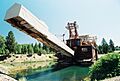
Sumpter Valley Gold Dredge
The Sumpter Valley Gold Dredge is a massive machine used for placer mining (finding gold in riverbeds) near Sumpter. It started working in the 1930s along the Powder River. This dredge shows a later, very mechanical way of mining gold in Eastern Oregon. It's a huge piece of equipment that helped shape the region's gold rush history.
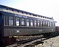
Sumpter Valley Railway Historic District
The Sumpter Valley Railway was a narrow-gauge railroad that ran between Baker City and Prairie City. This railway was super important for moving timber, gold, and people through the rugged landscape of Eastern Oregon. The historic district includes parts of the old railway, reminding us of how vital trains were for transportation and industry.
Superintendent's House (Sumpter)
The Superintendent's House at 271 S. Mill Street in Sumpter was likely home to a manager or important person involved in the local mining or railway operations. It gives us an idea of where and how the leaders of these industries lived.
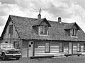
Unity Ranger Station
The Unity Ranger Station is located in the Wallowa-Whitman National Forest near Unity. Similar to the Antlers Guard Station, this station was important for managing the forest and supporting the work of forest rangers.
Images for kids
-
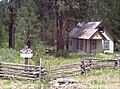
The Antlers Guard Station, built by the CCC.
-

Historic Main Street in Baker City.
-

The Baker Municipal Natatorium.
-
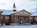
The historic Churchill School.
-
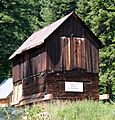
The old Cornucopia Jailhouse.
-
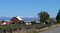
The James O. Maxwell Farmstead.
-
The Oregon Commercial Company Building.
-
The former St. Elizabeth Hospital.
-
The Sumpter Valley Gold Dredge.
-
A railcar from the Sumpter Valley Railway.
-
The Superintendent's House in Sumpter.
-
A bunkhouse at the Unity Ranger Station.


_(bakDA0095a).jpg)


See also
- National Register of Historic Places listings in Oregon
- Listings in neighboring counties: Adams, Grant, Malheur, Wallowa, Washington, Union
- Historic preservation
- History of Oregon
- Lists of Oregon-related topics
External links
- Oregon Parks and Recreation Department, National Register Program
- National Park Service, National Register of Historic Places site
