
Baker City, Oregon facts for kids
Quick facts for kids
Baker City
|
|
|---|---|

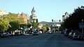
Main Street
|
|
| Motto(s):
"On the Historic Oregon Trail."
|
|

Location in Oregon
|
|

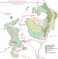
Baker City along I-84 in Oregon, surrounded by sections of Wallowa–Whitman National Forest.
|
|

Baker City
Location in Oregon

Baker City
Location in the United States

Baker City
Location in North America
|
|
| Country | United States |
| State | Oregon |
| County | Baker |
| Platted | 1865 |
| Incorporated | 1874 |
| Area | |
| • Total | 7.16 sq mi (18.55 km2) |
| • Land | 7.16 sq mi (18.55 km2) |
| • Water | 0.00 sq mi (0.00 km2) |
| Elevation | 3,451 ft (1,052 m) |
| Population
(2020)
|
|
| • Total | 10,099 |
| • Density | 1,410.08/sq mi (544.40/km2) |
| Time zone | UTC−08:00 (Pacific) |
| • Summer (DST) | UTC−07:00 (Pacific) |
| ZIP Code |
97814
|
| Area code(s) | 541 |
| FIPS code | 41-03650 |
| GNIS feature ID | 2409773 |
Baker City is a city in Oregon, United States. It is the main city and county seat of Baker County, Oregon. The city was named after Edward Dickinson Baker, who was a U.S. Senator. He was the only U.S. Senator ever killed while serving in the military. In 2020, about 10,099 people lived in Baker City.
Contents
History of Baker City

Baker City was first planned out in 1865. It started growing slowly. A post office opened in 1866, but Baker City didn't become an official city until 1874. Even before it was officially a city, it became the county seat in 1868. This meant it was the main city for the county's government.
The city and county are named after U.S. Senator Edward D. Baker. He died in 1861 while leading soldiers during the American Civil War.
In 1884, the Oregon Short Line Railroad came to Baker City. This helped the city grow a lot. By 1900, it was the biggest city between Salt Lake City and Portland. It became an important trading center for the whole region. In 1910, people in Baker City voted to shorten the name to just Baker. This change became official in 1911. Later, in 1989, another vote brought the name back to Baker City.
The Roman Catholic Diocese of Baker was created in 1903. After this, the Saint Francis de Sales Cathedral was built in Baker City. The city has also been a special place for watching solar eclipses. In 1918, the U.S. Naval Observatory came to Baker to watch a solar eclipse. The city was also in the path of a solar eclipse in 2017.
Recently, there have been some changes in the city's leadership. In 2023, the city council made some changes to who was mayor. Later, all the city council members, including the mayor, decided to resign. This meant that the county commissioners had to appoint new people to fill these roles.
Geography and Climate
Baker City covers about 7.16 square miles (18.55 square kilometers) of land.
The city is located in a valley. To the east are the Wallowa Mountains. To the west are the Elkhorn Mountains, which are part of the Blue Mountains. The Powder River flows right through the middle of downtown Baker City. It then continues on its way to the Snake River.
Weather in Baker City
Baker City has a cool, dry climate. The temperature can change a lot between day and night. July is usually the warmest month, with an average temperature of about 65.1°F (18.4°C). The hottest temperature ever recorded was 109°F (43°C) in August 2018 and August 2024.
December is the coldest month, with an average temperature of about 28.6°F (-1.9°C). The coldest temperature ever recorded was -34°F (-37°C) in December 1983. May usually gets the most rain, about 1.46 inches (37 mm). The city gets about 27.3 inches (69 cm) of snow each year.
| Climate data for Baker City Municipal Airport, Oregon (1991–2020 normals, extremes 1928–present) | |||||||||||||
|---|---|---|---|---|---|---|---|---|---|---|---|---|---|
| Month | Jan | Feb | Mar | Apr | May | Jun | Jul | Aug | Sep | Oct | Nov | Dec | Year |
| Record high °F (°C) | 61 (16) |
66 (19) |
78 (26) |
89 (32) |
94 (34) |
103 (39) |
105 (41) |
109 (43) |
102 (39) |
90 (32) |
72 (22) |
60 (16) |
109 (43) |
| Mean maximum °F (°C) | 47.2 (8.4) |
54.0 (12.2) |
66.9 (19.4) |
76.5 (24.7) |
85.1 (29.5) |
91.4 (33.0) |
98.5 (36.9) |
98.2 (36.8) |
92.4 (33.6) |
79.6 (26.4) |
61.6 (16.4) |
49.7 (9.8) |
99.9 (37.7) |
| Mean daily maximum °F (°C) | 37.6 (3.1) |
43.9 (6.6) |
53.8 (12.1) |
60.7 (15.9) |
69.6 (20.9) |
76.8 (24.9) |
88.2 (31.2) |
88.2 (31.2) |
78.8 (26.0) |
63.7 (17.6) |
47.6 (8.7) |
37.4 (3.0) |
62.2 (16.8) |
| Daily mean °F (°C) | 28.8 (−1.8) |
33.5 (0.8) |
40.8 (4.9) |
45.9 (7.7) |
54.2 (12.3) |
60.6 (15.9) |
68.5 (20.3) |
67.7 (19.8) |
59.1 (15.1) |
47.1 (8.4) |
36.2 (2.3) |
28.6 (−1.9) |
47.6 (8.7) |
| Mean daily minimum °F (°C) | 20.0 (−6.7) |
23.2 (−4.9) |
27.8 (−2.3) |
31.0 (−0.6) |
38.8 (3.8) |
44.3 (6.8) |
48.9 (9.4) |
47.3 (8.5) |
39.3 (4.1) |
30.4 (−0.9) |
24.8 (−4.0) |
19.7 (−6.8) |
33.0 (0.5) |
| Mean minimum °F (°C) | −1.4 (−18.6) |
5.4 (−14.8) |
14.5 (−9.7) |
17.8 (−7.9) |
23.0 (−5.0) |
32.0 (0.0) |
37.4 (3.0) |
35.5 (1.9) |
25.7 (−3.5) |
15.0 (−9.4) |
6.4 (−14.2) |
−1.3 (−18.5) |
−7.9 (−22.2) |
| Record low °F (°C) | −30 (−34) |
−28 (−33) |
−5 (−21) |
7 (−14) |
15 (−9) |
26 (−3) |
30 (−1) |
27 (−3) |
17 (−8) |
2 (−17) |
−16 (−27) |
−34 (−37) |
−34 (−37) |
| Average precipitation inches (mm) | 0.70 (18) |
0.59 (15) |
0.77 (20) |
0.82 (21) |
1.46 (37) |
1.10 (28) |
0.55 (14) |
0.43 (11) |
0.44 (11) |
0.62 (16) |
0.73 (19) |
0.85 (22) |
9.06 (232) |
| Average snowfall inches (cm) | 7.3 (19) |
4.8 (12) |
2.7 (6.9) |
1.0 (2.5) |
0.1 (0.25) |
0.0 (0.0) |
0.0 (0.0) |
0.0 (0.0) |
0.0 (0.0) |
0.1 (0.25) |
4.0 (10) |
7.3 (19) |
27.3 (69.9) |
| Average precipitation days (≥ 0.01 in) | 10.5 | 8.5 | 10.2 | 9.7 | 10.3 | 8.1 | 3.6 | 3.1 | 3.6 | 6.4 | 9.1 | 10.6 | 93.7 |
| Average snowy days (≥ 0.1 in) | 7.8 | 5.7 | 3.5 | 2.3 | 0.3 | 0.0 | 0.0 | 0.0 | 0.0 | 0.4 | 5.0 | 8.4 | 33.4 |
| Source 1: NOAA (snow/snow days 1981–2010) | |||||||||||||
| Source 2: National Weather Service | |||||||||||||
People of Baker City
| Historical population | |||
|---|---|---|---|
| Census | Pop. | %± | |
| 1870 | 312 | — | |
| 1880 | 1,258 | 303.2% | |
| 1890 | 2,604 | 107.0% | |
| 1900 | 6,663 | 155.9% | |
| 1910 | 6,742 | 1.2% | |
| 1920 | 7,729 | 14.6% | |
| 1930 | 7,858 | 1.7% | |
| 1940 | 9,342 | 18.9% | |
| 1950 | 9,471 | 1.4% | |
| 1960 | 9,986 | 5.4% | |
| 1970 | 9,354 | −6.3% | |
| 1980 | 9,471 | 1.3% | |
| 1990 | 9,140 | −3.5% | |
| 2000 | 9,860 | 7.9% | |
| 2010 | 9,828 | −0.3% | |
| 2020 | 10,099 | 2.8% | |
| Sources: U.S. Decennial Census |
|||
In 2010, there were 9,828 people living in Baker City. There were 4,212 households and 2,529 families. The population density was about 1,372 people per square mile (529.8 per square kilometer).
Most people in the city (about 94.57%) were White. About 1.12% were Native American. Other groups included Asian, African American, and Pacific Islander people. About 3.52% of the population was Hispanic or Latino.
About 24.5% of households had children under 18. About 45.1% were married couples. About 40.0% were not families. The average household had 2.25 people. The average family had 2.85 people.
The population included people of all ages. About 23.7% were under 19 years old. About 20.5% were 65 years or older. The average age in the city was 44 years.
Arts and Culture
Yearly Events
Baker City has many fun events each year. One popular event is the Miners' Jubilee. It happens on the third weekend of July. This festival celebrates the area's history of mining. It also remembers when the movie Paint Your Wagon was filmed there in 1969.
The Miners' Jubilee started in 1934. It stopped for a while during World War II. It was brought back in 1975 by Richard and Marge Haynes. Now, the Baker County Chamber of Commerce organizes the celebration.
Museums and Interesting Places
,_01.jpg)
The Baker Historic District is a special area in downtown Baker City. It is listed on the National Register of Historic Places. This district covers about 42 acres (17 hectares) around Main Street. It has over 130 buildings, many built between the late 1880s and 1915. These include old commercial buildings, the city hall, and churches.
The Baker City Tower is a nine-story building in the historic district. It is the tallest building east of the Cascade Range in Oregon. It opened in 1929 as a hotel. It has cool Art Deco style with eagle decorations.

Another important building is the Geiser Grand Hotel. This large hotel opened in 1889. It was very fancy for its time, with electric lights and an elevator. It was first called the Washauer Hotel. It became the Geiser Grand around 1895.
The Baker Heritage Museum used to be called the Oregon Trail Regional Museum. It is in a building that was once a swimming pool, built in 1920. The museum shows the history of the area. You can learn about mining, ranching, and early life in Baker City. The Adler House Museum is also part of it. It shows the home of Leo Adler, who was a kind person who gave a lot of money to Baker County.
About 5 miles (8 km) east of the city is the National Historic Oregon Trail Interpretive Center. This center has exhibits and shows about the Oregon Trail. You can even see the actual ruts left by wagons on the trail. The center is managed by the Bureau of Land Management and volunteers.
Other interesting places in Baker City include the Crossroads Art Center. There is also the downtown U.S. Bank, which has a display of gold. This includes the famous Armstrong Nugget, which weighs over 80 ounces (2.3 kg). The Eltrym is Baker City's only movie theater.
Sports and Fun Activities
Baker City is a great place for sports and outdoor fun. The Baker City Cycling Classic is a series of bicycle races held in and around the city. Similar races, called the Elkhorn Classic, were also held here until 2011.
The city also hosts high school basketball tournaments. These are the Oregon School Activities Association Class 1A girls and boys tournaments. They take place at Baker High School in March. The Oregon East−West Shrine Game, a high school football game, is held here in July. The Hell's Canyon Motorcycle Rally also happens in Baker City in July.
Sections of the Wallowa–Whitman National Forest are near Baker City. The city is the headquarters for this forest. In the forest, you can go hiking, biking, fishing, hunting, and camping. You can also enjoy winter sports and watch wildlife.
Getting Around

Interstate 84 (I-84) runs along the east side of Baker City. U.S. Route 30 goes through the downtown area. Other roads like Oregon Route 7 and Oregon Route 86 connect Baker City to nearby towns.
The city has its own airport, the Baker City Municipal Airport. It is about 3 miles (5 km) north of downtown. Northeast Oregon Public Transit offers trolley service around Baker City. It also has bus service to La Grande on weekdays.
The Union Pacific Railroad (UP) serves Baker City for freight. This means trains carry goods to and from the city. In the past, between 1977 and 1997, Baker City was a stop for Amtrak's Pioneer passenger train.
Schools and Libraries
Baker City is part of the Baker School District 5J. This district includes several schools:
- Baker High School
- Eagle Cap Innovative Jr/Sr High School
- Baker Middle School
- Brooklyn Primary
- South Baker Intermediate
It also includes Keating Elementary and Haines Elementary in the county. District 5J serves about 1,800 students. It is the largest school district in Baker County.
Baker Middle School was designed by Ellis F. Lawrence. It was finished in 1917. The building is made from local stone.
The main branch of the Baker County Library system is in downtown Baker City. There are also library branches in other towns like Haines, Huntington, Halfway, Richland, and Sumpter.
Media
Baker City has one newspaper, the Baker City Herald. It is published three times a week. The city also has five radio stations:
- KBKR (1490 AM)
- KKBC (95.3 FM)
- KWRL (102.3 FM)
- KCMB (104.7 FM)
- KANL (90.7 FM)
Television
Baker City receives television channels from Portland, Oregon, and Boise, Idaho.
- K44AJ Channel 44 (KATU ABC Portland)
- K42AI Channel 42 (KOIN CBS Portland)
- K46AM Channel 46 (KTVB NBC Boise)
- K18KI Channel 18 (KTVB NBC Boise)
- K36NP-D Channel 36 (KGW NBC Portland)
- K40AJ-D Channel 40 (KPTV FOX Portland)
- K20IV Channel 20 (KTVR PBS Lagrande)
Sister City
In 1996, Baker City became a sister city with Zeya, Russia. This means the two cities have a special friendship. The Baker School District also agreed to help create a student exchange program between the two communities.
Images for kids
-
Main Street
-

Location in Oregon
-
Baker City along I-84 in Oregon, surrounded by sections of Wallowa–Whitman National Forest.
-
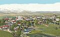
Aerial view, about 1929
-
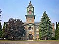
Baker City Hall
-
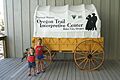
Baker City is home to the National Historic Oregon Trail Interpretive Center.
-
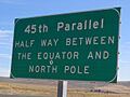
The 45th Parallel sign near Baker City, on Interstate 84
See also
 In Spanish: Baker City para niños
