
National Register of Historic Places listings in Manistee County, Michigan facts for kids

Have you ever wondered about the oldest and most special buildings or places in your community? In the United States, there's a special list called the National Register of Historic Places. It helps protect and celebrate important historical sites across the country.
This article is all about the amazing places in Manistee County, Michigan that are on this list. These places tell us stories about the past, from old houses and churches to a cool ship and even a house made of bottles! There are 18 different spots in Manistee County that are recognized for their history, and one of them is so important it's called a National Historic Landmark. Let's explore them!
Contents
- What is the National Register of Historic Places?
- Historic Places in Manistee County
- Simeon Babcock House
- SS City of Milwaukee
- First Congregational Church
- John J. Makinen Bottle House
- Manistee Central Business District
- Manistee County Courthouse Fountain
- Manistee Harbor, South Breakwater
- Manistee Iron Works Machine Shop
- Manistee North Pier
- Orchard Beach State Park
- Our Saviour's Evangelical Lutheran Church
- Portage Point Inn Complex
- Ramsdell Theatre
- Sandenburgh-Rogers Summer Resort Complex
- Udell Lookout Tower
- Images for kids
What is the National Register of Historic Places?
The National Register of Historic Places is like a hall of fame for historic buildings, sites, structures, objects, and districts. It's managed by the National Park Service, which is part of the U.S. government. When a place is added to this list, it means it's important to the history of the local area, the state, or even the whole country.
Being on the list helps to:
- Recognize history: It officially says, "Hey, this place is special!"
- Protect places: It encourages people to take care of these historic spots.
- Get help: Sometimes, being on the list can help owners get grants or tax breaks to fix up and preserve the property.
It's a way to make sure that future generations can also learn from and enjoy these important parts of our past.
Historic Places in Manistee County
Manistee County has many fascinating places that have earned a spot on the National Register. Each one has its own unique story.
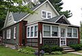
Simeon Babcock House
- Location: 420 Third Street, Manistee, Michigan
- Listed: November 30, 1999
This beautiful house is named after Simeon Babcock. It's a great example of the homes built in Manistee long ago. Imagine what life was like for families living here over a hundred years ago!
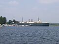
SS City of Milwaukee
- Location: Marine Terminal Railyard, eastern slip, Manistee, Michigan
- Listed: December 14, 1990
- Special Note: This is a National Historic Landmark!
The City of Milwaukee is not just any ship; it's a huge car ferry! It was built in 1931 and used to carry trains, cars, and passengers across Lake Michigan. It's one of the last remaining car ferries of its kind. Being a National Historic Landmark means it's one of the most important historic places in the entire country. It's like a floating museum that shows us how people traveled and transported goods in the past.
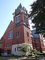
First Congregational Church
- Location: 412 South 4th Street, Manistee, Michigan
- Listed: June 25, 1974
This church is a significant landmark in Manistee. Its architecture and long history make it a special place in the community. Many people have gathered here over the years for services and events.
John J. Makinen Bottle House
- Location: 14551 Wuoksi Avenue, Kaleva, Michigan
- Listed: July 9, 1987
This house is super unique because it's made partly out of glass bottles! John J. Makinen built it using thousands of bottles, creating a truly one-of-a-kind home. It's a fantastic example of creative and resourceful building.
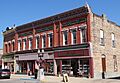
Manistee Central Business District
- Location: Roughly bounded by Maple, Washington, Water, and River Streets, Manistee, Michigan
- Listed: May 7, 1982
This isn't just one building, but a whole area! The Manistee Central Business District includes many historic buildings in the heart of downtown Manistee. These buildings show what the city looked like when it was a busy logging and shipping center. Walking through this district is like stepping back in time.
Manistee County Courthouse Fountain
- Location: Onekama Village Park, Onekama, Michigan
- Listed: February 8, 1988
This beautiful fountain once stood at the Manistee County Courthouse. Now, it's a charming feature in Onekama Village Park, adding a touch of history and beauty to the public space.
Manistee Harbor, South Breakwater
- Location: Mouth of the Manistee River, at Lake Michigan, Manistee, Michigan
- Listed: October 20, 1995
Breakwaters are structures built to protect harbors from waves. The South Breakwater at Manistee Harbor has been important for guiding ships safely into the Manistee River from Lake Michigan for many years.
Manistee Iron Works Machine Shop
- Location: 254 River Street, Manistee, Michigan
- Listed: July 19, 2010
The Manistee Iron Works was a very important factory in the area, making machinery for different industries. This machine shop is a reminder of Manistee's industrial past and the skilled workers who built things there.
Manistee North Pier
- Location: West end of Fifth Avenue, Manistee, Michigan
- Listed: May 17, 1990
This pier, along with its lighthouse, helps guide boats into the Manistee River. Piers are essential for navigation and have been a part of Manistee's waterfront for a long time.
Orchard Beach State Park
- Location: 2064 North Lakeshore Road, Manistee, Michigan
- Listed: December 8, 2009
Orchard Beach State Park is a popular spot for outdoor fun, but it also has a rich history. The park's design and some of its older structures reflect the early days of state parks in Michigan.
Our Saviour's Evangelical Lutheran Church
- Location: 300 Walnut Street, Manistee, Michigan
- Listed: August 21, 1972
Another historic church in Manistee, this building has served its community for many decades. Its architecture tells a story about the people who built it and worshipped there.
Portage Point Inn Complex
- Location: 8513 South Portage Point Drive, Onekama, Michigan
- Listed: October 8, 1985
This complex was once a grand resort where people came to relax and enjoy the beautiful lakeshore. It shows us how people used to vacation and the kind of places they stayed in.
Ramsdell Theatre
- Location: 101 Maple Street, Manistee, Michigan
- Listed: January 13, 1972
The Ramsdell Theatre is a stunning historic theater that has hosted countless performances, from plays to concerts. It's a true gem for the arts in Manistee and has been entertaining audiences for over a century.
Sandenburgh-Rogers Summer Resort Complex
- Location: 2046 Crescent Beach Road, Onekama Township, Parkdale
- Listed: December 6, 1996
Similar to the Portage Point Inn, this was another summer resort. It highlights the importance of Manistee County as a popular vacation destination in the past, especially along its beautiful lakes.
Udell Lookout Tower
- Location: Forest Road 5207, Huron-Manistee National Forest, Wellston
- Listed: August 22, 1996
This tower was used to spot forest fires, helping to protect the vast forests of Michigan. It's a reminder of the important work done to keep our natural areas safe.
Images for kids
-

The Simeon Babcock House
-
The City of Milwaukee car ferry
-
First Congregational Church
-
The unique John J. Makinen Bottle House
-
A building in the Manistee Central Business District
-
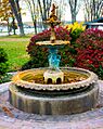
The Manistee County Courthouse Fountain
-
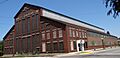
The Manistee Iron Works Machine Shop
-

Manistee North Pierhead Lighthouse
-

Orchard Beach State Park
-

Our Saviour's Evangelical Lutheran Church
-
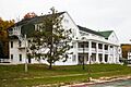
The historic Portage Point Inn
-

The beautiful Ramsdell Theatre
-

The Sandenburgh-Rogers Summer Resort Complex


